
MSS Color Mosaic of the Western United States
Mosaics of entire continents or subcontinents became plausible when we acquired and reprocessed (to minimize tonal differences ) enough cloud-free Landsats images. The USDA's Soil Conservation Service put together the first image of the entire United States in 1974. The General Electric Company, under contract to the National Geographic Society (NGS), produced the first color renditions. We reproduce here a portion of the NGS magazine's Landsat "map" of the U.S., which was part of its bicentennial (1976) anniversary issue, in the natural color version (they projected the MSS band 7
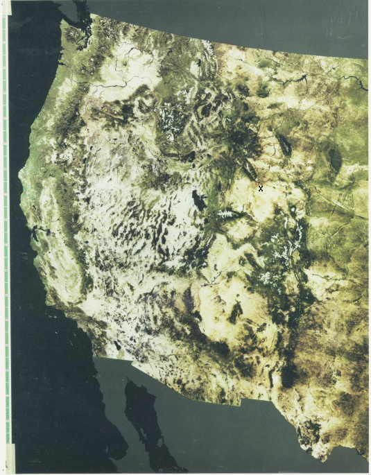
through a green filter and bands 4 and 5 through blue and red filters). It shows all of the western U.S. into the Great Plains beyond Denver and the Black Hills. Blackish areas on land are either water bodies (such as the Great Salt Lake) or vegetated mountain slopes. Obviously, relatively little detail in the landscape is visible at this scale (~1:11,000,000) but the impression of the overall geomorphology and geologic structures that set the western U.S. apart is striking. Compare this rendition with the equivalent area in the NOAA Advanced Very High Resolution Radiometer image presented on page 6-1.
Casper Mountain, Wyoming Enlarged Subscene
At the other extreme, the versatility of Landsat subscene images when enlarged to show localized details is evidenced by this next image.
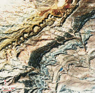
The area here, representing about 18 km (11 mi) across the image base (at a scale of 1:100,000), is part of a series of strata dipping to the southeast in a fold belt along the Casper Arch in central Wyoming (at the X in the NGS mosaic).
The degree to which we can extract useful information from images at 30 m resolution became apparent in a situation experienced by this writer. In an enlargement of a Thematic Mapper scene containing Baltimore, Maryland, and Washington, District of Columbia, from which he produced a subset around Baltimore, he spotted the backyard of his home near Columbia, MD, because of its well-watered lawn (strong IR reflectance) relative to those of neighbors on either side whose uncared-for grasses had turned brown in the summer heat. He noticed a small black spot to the south in the image which he surmised was the apron of a swimming pool at a neighbor's home three doors down, not visible to him because of a fence. When he asked the neighbor if the pool had an asphalt apron, the "yes" answer convinced him of the power of TM imagery to invade the "hidden" for arcane information. Still, the Landsat TM resolution is a far cry from that of some military spy systems, which, some people claim, can read license plates and locate golf balls on a course.
Color Mosaic of Southern Europe: The Alps
Another magnificent mosaic, made as a variant of true color, shows the entire Alps (Alpine Mountain Chain) across southern Europe, including all of Switzerland and Austria, and parts of eastern France, southern Germany, Czechoslovakia, Slovenia, Croatia, and northern Italy.
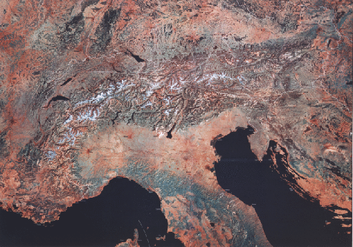
The map inset locates the main mountain subdivisions. Westermann Satellite Maps prepared this map, which, shortly after its production, became a standard aid for teaching geography to students in many European countries.
Mosaic of Iran, Pakistan, and India
We close with one of the most sensational mosaics yet made from Landsat images, assembled by R.D. Lawrence and R.O. Rogers of the Geology Department at Oregon State University.
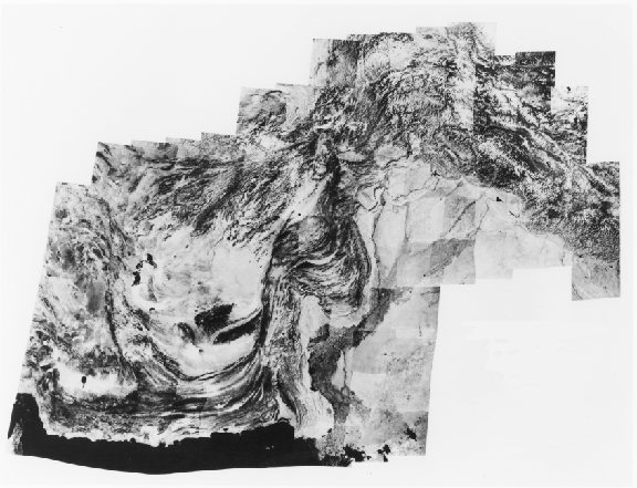
Pakistan Landsat Mosaic
The region displayed in this black and white, red band mosaic includes nearly all of Pakistan, part of eastern Iran and southern Afghanistan, and a smaller segment of India, extending over about 2,100 km (1,305 mi) from west to east. We drew the principal structural features on the locator map below.
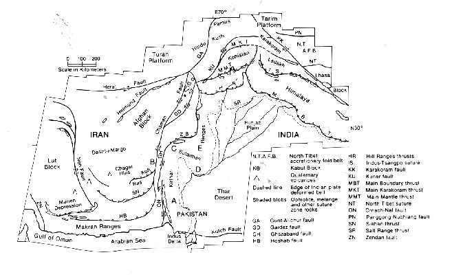
The continuous mountain belt starting with the east-west Makran Ranges, then the north-trending Kirthar and Sulaiman Ranges in Pakistan, and the great bend of the Hindu Kush joining the north-west-trending western Himalayas, is the consequence of the monstrous, still continuing, collision of the Indian subcontinent during the last 130 million years as it drifted north, striking the underbelly of Asia along a vast subduction zone.
The ability to produce mosaics from high resolution imagery such as Landsat opens a new dimension in the study of Earth's land masses at continental and regional scales.
Computer displays lose much of the detail from this resolution, but when we prepare a large space photomosaic, either at the scale (1:,1,000,000), at which it is normally printed or at a moderately reduced scale (say, 1:2,500,000) to keep it’s size manageable, we retain most of the original information. The chief users of mosaics, such as those shown above, are geographers, structural geologists, and geomorphologists, all of whom benefit from the panoramic vista afforded by seeing local features in a regional context.
These mosaics also dovetail nicely with the lower resolution views of continents at the hemispherical scale provided by meteorological satellites, such as Nimbus and GOES (see Section 14).

Collaborators: Code 935 NASA GSFC, GST, USAF Academy
Contributor Information
Last Updated: September '99
Webmaster: Bill Dickinson Jr.
Site Curator: Nannette Fekete
Please direct any comments to rstweb@gst.com.