
RADAR AND MICROWAVE REMOTE SENSING*
Radar Defined
Radar is an acronym for Radio Detection and Ranging. It operates in part of the microwave region of the electromagnetic spectrum, specifically in the frequency interval from 40,000 to 300 megahertz (MHz). The latter frequency extends into the higher frequencies of the broadcast-radio region. Commonly used frequencies and their corresponding wavelengths are specified by a band nomenclature, as follows:
Ka Band: 40,000-26,000 MHz (0.8-1.1 cm wavelength)
K Band: 26,500-18,500 MHz (1.1-1.7 cm)
X Band: 12,500-8,000 MHz (2.4-3.8 cm)
C Band: 8,000-4,000 MHz (3.8-7.5 cm)
L Band: 2,000-1,000 MHz (15.0-30.0 cm)
P Band: 1,000- 300 Mhz (30.0-100.0 cm)
Unlike other sensors that passively sense radiation from targets illuminated by the Sun or thermal sources, radar generates its own illumination (hence, it is active; another example is the flash camera) by sending bursts or pulses of EM energy that reflect off of a target. A fraction of the reflected energy then returnsto the radar’s receiving antenna, which collects it and passes it to the electronic system. Thus, a radar system is a ranging device that measures distances as a function of round trip travel times (at light speed) of a directed beam of pulses (the signal, whose strength is measured in decibels, dB) spread out over specific distances. In this way radar determines the direction and distance from the instrument (fixed or moving) to an energy-scattering object. We can also derive information about target shapes and certain diagnostic physical properties of materials at and just below the surface by analyzing signal modifications.
8-1: In the Introduction Section, you learned that wavelength x frequency = the speed of light. By choosing the proper units, this equation can be derived: Wavelength (in cm) = 30/frequency (in GHz or 109cycles per second. Given a frequency of 20 GHz, what Wave Band would this radar pulse fall into? ANSWER
By supplying its own illumination, radar can function day and night and, for some wavelengths, without significant interference from blocking atmospheric conditions (e.g., clouds). These characteristics prompted radar development in World War II for tracking aircraft and ships. Ground (fixed) and airborne (mobile) radar systems are used extensively today for marine navigation and air traffic control. Imaging radar, mounted on air or space platforms, has proven especially useful in mapping cloud-shrouded land surfaces (a landforms map of Panama used this approach). This use also permits expressing surface shapes in regions heavily covered by vegetation (penetrated by some bands).
8-2:Why did radar play such a vital role in the Allies victory over Germany in World War II? ANSWER
This ability to mirror ground surfaces for displaying topography is a prime use of radars, which operate on moving platforms. This usefulness is strikingly confirmed in the radar image strip (SIR-A system on the Shuttle) that we show here, extending 300 km (200 mi ) to the northeast (right side) across the folded and dissected South American Andes in Bolivia. The image covers from the high plains (Altiplano) on the west to the lowlands (Amazon Basin) on the east. (Scroll to see this right end.)
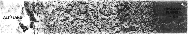
8-3: Care to guess why the Low plains are dark and the High (Alti) plains are light.
Radar systems, as well as passive sensors operating at microwave wavelengths (slightly shorter than radar), are also effective in detecting soil moisture and sea states.

Collaborators: Code 935 NASA GSFC, GST, USAF Academy
Contributor Information
Last Updated: September '99
Webmaster: Bill Dickinson Jr.
Site Curator: Nannette Fekete
Please direct any comments to rstweb@gst.com.