| Figure 1-1. Scale relationships for various geomorphic processes. The relationships are illustrative and are based on the work of Carey (1962). | 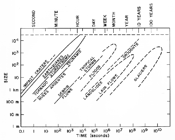 |
|---|
THE NATURE OF GEOMORPHOLOGY
Definitions
Geomorphology is the study of landforms and landscapes, including the description, classifiation, origin, development, and history of planetar surfaces. During the early part of this century, the study of regional-scale geomorphology was termed "physiography"(Salisbury, 1907). Unfortunately, physiography also became synonymouswith physical geography, and the concept became embroiled in controversy surrounding the appropriate concerns of that discipline. Some geomorphologists held to a geological basis for physiography and emphasized a concept of physiographic regions (Fenneman, 1938), A conflicting trend among geographers was to equate physiography with "pure morphology," divorced of its geological heritage. In the period following World War II, the emergence of process, climatic, and quantitative studies led to a preference by many Earth scientists for the term "geomorphology" in order to suggest an analytical approach to landscapes rather than a descriptive one.
In the second half of the twentieth century, the study of regional-scale geomorphology -the original physiography- was generally neglected. Russell (1958) attributed the decline of physiography to its elaborate terminology and to its detachment from evidence acquired by other disciplines, chiefly geology. Although the concept of physiographic regions endured among geologists (Thornbury, 1965; Hunt, 1967), geographers became much more interested in the details of man/land interactions and in the applications of modeling and systems analysis (Chorley and Kennedy, 1971) to geomorphology.
In the exploration of planetary surfaces by various space missions, the perspective of regional geomorphology has been the required starting point for scientific inquiry. Global studies of Mars (Mutch et al., 1976), the Moon (McCauley and Wilhelms, 1971), Mercury (Strom, 1984), and Venus (Masursky et al., 1980) resulted in the identification of "surface units"or physiographic provinces. The Colorado Plateau (Plate I-1) is an excellent example of a terrestrial physiographic province. Plate I-1 illustrates the use of a large-scale perspective to focus on this naturally defined region.
The term "mega-geomorphology" was introduced in March 1981 at the 21st anniversary meeting of the British Geomorpholgy Research Group. The proceedings of that meeting (Gardner and Scoging, 1983) reveal that the concept was not well defined. It clearly involves a return by geomorphologists to the study of phenomena on large spatial scales, ranging from regions to continents to planets. It also involves large time scales. Nevertheless, mega-geomorphology is merely a convenient term, unencumbered by past philosophical trappings, that emphasizes planetary surface studies at large scales.
The interrelation of temporal and spatial scales in geomorphology is illustrated by the tentative classification shown in Table 1-1. Of course, such a hierarchial ordering of geomorphic features is far from satisfying. As stated by Sparks (1971), classifications are arbitrary constructions designed to facilitate the discussionof diverse phenomena at the risk of some distortion of the truth. The scheme merely illustrates what was well known to the great geomorphologists at the last turn of the century. The large first order features, continents and ocean basins, persist and evolve over long time scales. Small high-order features are transient. Fundamental units appear at different orders. The old concept of physiographic regions was used to designate second- order forms, such as entire mountain ranges or coastal plains. Massive entities within a physiographic region might constitute a third-order form, such as a domal uplift. The details of the classification are unimportant as the analysis moves on to exploring the explanation of phenomena.
This book explores mega-geomorphology. The parent science of geology has long emphasized large-scale features in its central discipline of tectonics. Although early proponents of largescale crustal mobilism, such as Alfred Wegener, were decidedly renounced by the mainstream scientific community, their ideas provided the stimulus for work that eventually transformed the Earth sciences.The plate tectonic model that emerged in the late 1960s was but a quantitatively geophysical confirmation of the elegant hypothesis developed by careful attention to large-scale structural patterns on the Earth´s surface. Of course, this is not intended to imply that microscale studies are unimportant in structural geology. Such studies tell much about the details of rock deformation and the fabric of resulting materials. The lesson here is that significant science occurs at all scales of study. Scientists neglect the study of one spatial scale to the peril of their advancement to understanding.
| Order | Scale (km2) |
Approximate Time Scales
of Persistence (years) | |
|---|---|---|---|
| 1 | 107 | Continents, ocean basins | 108-109 |
| 2 | 106 | Physiographic provinces, shieds, depositional plains | 108 |
| 3 | 104 | Medium-scale tectonic units (sedimentary basins, mountain massifs, domal uplifts) | 107-108 |
| 4 | 102 | Smaller tectonic units (fault blocks, volcanoes, troughs, sedimentary subbasins, individual mountain zones) | 107 |
| 5 | 10-102 | Large-scale erosional/depositional units (deltas, major valleys, piedmonts) | 106 |
| 6 | 10-1-10 | Medium-scale erosional/depositional units or landforms (floodplains, alluvial fans, moraines, smaller valleys and canyons) | 105-106 |
| 7 | 10-2 | Small-scale erosional/depositional units or landforms (ridges, terraces, sand dunes) | 104-105 |
| 8 | 10-4 | Larger geomorphic process units (hillslopes, sections of stream channels) | 103 |
| 9 | 10-6 | Medium-scale geomorphic process units (pools and riffles, river bars, solution pits) | 102 |
| 10 | 10-8 | Microscale geomorphic process units (fluvial and eolian ripples glacial striations) | - |
(Modified from Tricart, 1965; Chorley et al., 1984)
Scales of Study
Callieux and Romani (1981) believe that there are two major trends in modern geomorphology: toward quantification and toward more varied extensions. In the latter, they see an extension of concern to other scientific disciplines, to applied problems, to longer time scales, and to more ancient features. They also see an extension to greater spatial scales.
The operative temporal and spatial scales of geologic phenomena span an immense range (Figure 1-1). Note that fluvial phenomena (floods) occupy an intermediate position in this scaling. The various phenomena all follow the general equation:
where S is the size of the feature, T is the time (duration), and a and b are constants. The constant b is generally a scaling factor (equal to about 1.0), showing that big phenomena tend to last longer. The constant a seems to relate to the intensity of the process ( i.e., how rapidly it expends energy per unit area).
Despite the utility of such scaling relationships, summarized in the concept of allometry (Bull, 1975), problems arise at very large spatial and temporal extrapolations (Church and Mark, 1980). However, perhaps more important than the details of scaling is the intellectual excitement of multiscale thinking. In his insightful review of geomorphological processes on planetary surfaces, Sharp (1980) observed that one of the lessons from the comparative study of landforms on different planets is to "think big." The same can be said of the application of space-age global remote sensing technology to the study of terrestrial landforms. At the turn of the century, geomorphologists are once again ready to think big.
| Figure 1-1. Scale relationships for various geomorphic processes. The relationships are illustrative and are based on the work of Carey (1962). | |
|---|
Time scales are also important in defining the nature of geomorphic investigations. The role of time scales in geomorphology is discussed more fully by Schumm and Lichty (1965) and Cullingford et al. (1980). The macroscale of geomorphic time is that over which major phases of erosion or deposition occur. These phases, which may be cyclic, are controlled by the geological processes of regional warping, mountain building, and crustal plate movement. The scientific questions arising at the temporal macroscale concern the evolution of the planetary surface over millions of years. Many of the approaches to this time scale are historical, using elements of the landscape to reconstruct past events.
The mesoscale of geomorphic time is that which treats major changes in landforms and landscapes over hundreds to thousands of years. Examples include the growth and recession of glaciers, the aggravation and degradation of rivers, and the progradation and recession of shorelines. These changes generally involve a complex interplay between tectonic and climatic controls on geomorphological processes. This is perhaps the most fertile area of geomorphic analysis, since it involves continual intellectual feedback between historical reconstruction and the study of modern processes.
The microscale of geomorphic time is that over which the major variables of tectonism and climate are assumed to be constant. The processes that characterize sand dunes, glaciers, rivers, or beaches are assumed to reflect only the short-term events that dictate local flow physics. This is the temporal view of both the engineer and the process geomorphologist. Because of the ability to measure events that occur at the approximate scale of a year, this temporal scale is the richest source of quantitative geomorphic data. The ability to fashion predictions from studies at this scale also makes such studies immensely useful in application. People inhabit the dynamic surface of the Earth and must interact with its surficial processes.
Reasoning from one scale to another is an instinctive mental exercise for scientists. The geomorphologists of the 19th century generally perceived the details of landforms from foot, horseback, or even hands and knees. From such detail, they generalized to the larger synthesis of landscape form and processes. Nevertheless, they also realized the importance of a broad view. The great vistas of the Alps, Appalachians, and Colorado Plateau inspired regional assessment of landscape types.
The reasoning from distant views to the details of site specific investigation is perhaps no better illustrated than in G.K. Gilbert's study of the Henry Mountains in Utah (Gilbert, 1877). Gilbert's brilliant concept of the laccolith structure and its modification by erosional processes was conceived before he visited the scene! His field notes show that he conceived the relationships from distant views as he approached the mountains along the Waterpocket Fold (Pyne, 1980, pp. 66-67).
Fundamental Concepts
Most geomorphologists would agree that certain fundamental assumptions underlie all geomorphological investigations. Whether termed "fundamental concepts" (Thornbury, 1969), "philosophical assumptions" (Twidale, 1977), "paradigms" (Ollier, 1981), or "basic postulates" (Pitty, 1982), these ideas constitute a "conventional wisdom" for the science. One such fundamental concept involves the inherent complexity of landscapes. This concept has impeded the development of grand theories that survive the test of explaining numerous local features. Another basic assumption involves climatic morphogenesis, emphasizing the role of climatically controlled processes of landform genesis. Several of these concepts have yielded major intellectual controversy, such as the role of cataclysmic processes in shaping the landscape. These concepts apply to geomorphology of all scales. Table 1-2 outlines some important concerns.
Role of Geomorphic Studies
There is no question that geomorphology is a science of fundamental importance. We inhabit, indeed all life evolved at, a dynamic interface between a rocky planetary surface and its atmosphere and hydrosphere. However, geomorphology is also a science in transition, in which serious questions arise concerning basic methodology and philosophy. During the last half of this century, many geomorphologists neglected the macroscale concept of landscape development over time by the action of processes on geologic structure. Instead, they emphasized the study of process alone and the short- term response of landforms to processes. When most geomorphologists abandoned the Davisian model and its attendant concern with denudation chronology, many embraced a systems approach, with emphasis on statistical analysis and predictive modeling of process/response phenomena on the Earth´s surface. However, this change in methodology also engendered a change in the scale of phenomena studied. Smallscale features and short- acting processes proved to be most amenable to the new methodology. The global concern with longacting denudation was ignored, not because of its importance, but because of methodological inadequacies in its past study.
The dominance of process studies in geomorphology is exemplified in the following statement of Thornes and Brunsden (1977, p. 116): "The current paradigm is one in which process studies prevail effected principally and increasingly through mathematical and stochastic models." In contrast, Church (1980) writes, "Contemporary process studies are of little worth in evaluating landscape evolution." The fact remains that landscape evolution remains a critical concern for geomorphology, despite past problems in the implementation of its study. Thornbury (1969) made a key point when he noted that geomorphology, although concerned primarily with present-day landscapes, attains its maximum usefulness by historical extension. Although some upward extrapolation is possible (Church and Mark, 1980), a balanced approach to these problems demands research on very large temporal and spatial scales.
It can be argued that the greatest advances in science occur not by reaction to present concerns-embellishing models established in current paradigms. Rather, major advancement comes from a concentration on the anomalies in the present scientific understanding-the points at which models fail. The clear inability of small-scale process studies to be extrapolated to largescale geomorphic concerns should not be viewed as a failure of geomorphic theory. Indeed, it is an opportunity. Geomorphologists need to engage in large-scale studies, employing the most modern research techniques of remote sensing, computer modeling, and geochemical dating. It would be refreshing to see what comes of some downward extrapolation.
| Uniformitarianism | Similar geomorphic processes that operate today operated throughout geologic time. | Unusual processes without modern analogs occurred in the geologic past. |
| Gradualism | Relatively frequent, modest-sized processes dominate in the progressive changing of the landscapes over long time periods. | Cataclysmic processes and changes are most important in landscape evolution. |
| Orderliness | Erosional agents on a planetary surface produce an orderly sequence of landforms as a function of time. | Some landscapes arise from disorderly processes. |
| Morphoclimatic Zonation |
Landscapes reflect the influence of certain climatic processes by developing a characteristic assemblage of landforms. | Geologic structure predominates over climate in influencing landform assemblages. |
| Youthfulness of Topography |
Most of the Earth´s topography is no older than Pleistocene. | In stable tectonic areas, extensive landscapes of Tertiary, or even Mesozoic, age are preserved. |
| Legacy of the Pleistocene |
The geologic and climatic changes of the Pleistocene were critical in the shaping of most landscapes. | Relict landscape elements persist despite Pleistocene changes and comprise palimpsests. |
| Modernism | Geomorphology is primarily concerned with present- day processes that shape present-day landscapes. | Geomorphology attains its maximum usefulness by historical extension, analyzing ancient conditions. |
| Simplicity | It is necessary to search for simplicity in geomorphological systems. | Complexity of geomorphic systems is more common than Simplicity. |
Regional landforms analysis can be approached with several different emphases. Since these derive from traditional geomorphic subdisciplines, this section will review several frameworks for study.
Process Studies and Systems Analysis
Process geomorphologists employ field, laboratory, and analytical techniques to study processes presently active on the landscape. The work relies heavily on the incorporation of other disciplines, including pedology (the study of soils), soil mechanics, hydrology, geochemistry, remote sensing, hydraulics, statistics, geophysics, civil engineering, and geology. To organize the complexities of process interactions, most geomorphologists utilize systems analysis. The landscape is idealized as a series of elements linked by flows of mass and energy. Process studies measure the inputs, outputs, transfers, and transformations that characterize these systems. Although systems analysis does not constitute a true theory for geomorphology, it does serve the useful purpose of organizing process studies into a framework that allows modeling and prediction, especially when data are fed into digital computers.
The systems approach to geomorphology has been extensively reviewed by Chorley and Kennedy (1971) and by Chorley et al. (1984). Table 1-3 summarizes some of the most important systems terms and their usage.
Climatic Geomorphology
Climatic geomorphology developed as an alternative to Davisian theory for landscape evolution. Climatic geomorphologists hold that modern relief- forming mechanisms differ as a function of climate and that their relief products define major morphoclimatic zones on the globe. Climatic geomorphologists systematized the various process combinations that occur in the morphoclimatic zones. Major practitioners include J. Tricart and A. Callieux of France and J. Budel of Germany. German geomorphology is especially dominated by the approach of Budel (Bremer, 1984).
A related concept is climate-genetic geomorphology (Budel, 1982), which emphasizes the study of exogenic forces and especially climatic change as controls on the evolution of relief. Many climatic geomorphologists hold that little of the extant relief on the Earth is the product of modern relief- forming processes. Most is instead inherited from past morphoclimatic controls. The study of relief generations or landscape evolution therefore consists of interpreting climatic changes in relation to certain diagnostic landscape features.
An example of a useful designation of a morphoclimatic region is the periglacial zone. The term "periglacial" has come to mean the complex of cold-climate processes and landforms, including, but not limited to, those near active glaciers. A key feature is frost action, especially the freezing and thawing of ground. A related, but not necessarily coincident, phenomenon is permafrost (perennially frozen ground). Permafrost covers 20 to 25 percent of the Earth´s land surface. It manifests itself on the landscape when large quantities of ground ice are present. This ice may form wedges that penetrate vertically into the regolith, growing with seasonal meltwater flow into tension cracks. Polygonal patterns characterize the ground surface.
Where ice-rich permafrost is degraded by geomorphic, vegetational, or climatic change, it forms a complex landscape known as thermokarst. Depressions form where zones of ground ice are removed by melting. In extreme cases, such as near Yakutsk in eastern Siberia, large valleys may form by the coalescence of thermokarst depressions.
During the coldest periods of the Pleistocene, the periglacial zone extended to cover 40 percent of the Earth´s land surface. Hillslopes were mantled with frost-shattered rubble that moved downslope during seasonal freezing and thawing. Patterned ground (polygons and stripes) developed as the frost rubble was further sorted by seasonal changes. Even huge streams of rubble and ice-cored rock glaciers formed in areas of especially high debris production. The relicts of this periglacial activity characterize many of the modern humid-temperature zones, such as Pennsylvania, Wisconsin, England, and Poland.
| Term | Usage | Example |
|---|---|---|
| Cascade | A type of system through which energy and mass flow from one subsystem to another | Movement of water and sediment through a drainage basin. |
| Feedback | Output to one system acts as input to itself. The effect can be self-enhancing (positive feedback) or self-refulating (negative feedback). | As river bar is eroded, it becomes more streamlined in shape, which reduces erosion (negative feedback). |
| Equilibrium | A balance between form and process. | Hillslopes form as a balance between rock resistance and erosional processes. |
| Threshold | A condition that must be achieved for a system to pass from one state to another. | A landslide can occur only when the driving forces exceed the resisting forces. |
| Equifinality | The derivation of similar final states in different ways from diverse origins. | Polygonal ground may form from desiccation, freezing, or volcanism. |
| Dynamic Equilibrium |
An equilibrium state maintained by a balance of fluctuations around a constantly changing system condition. | Rivers maintain an equilibrium of channel form as they continue long-term degradation. |
| Steady State | An equilibrium state maintained around a time invariant system condition. | Soil caly content increases by weathering until it reaches constant value |
Structural Geomorphology
Structural geomorphology derives from the fundamental observation that geologic structure dictates the resistance of Earth materials to degradational processes. The role of structure may be passive, in which case the composition of rocks or their discontinuities (joints, faults, and bedding) dictate the details of erosion. In this way, structure provides the boundary conditions for landscape denudation. Structure may also play an active role when tectonic processes create primary landforms and landscapes. Thus, volcanoes, fault-block mountains, grabens, and domes comprise fundamental elements of planetary surfaces.
The cuesta landscape of Riyadh, Saudi Arabia, is an excellent example of classic passive control degradation by rocks of varying resistance to erosion. Plate I-2 illustrates the use of this quality of regional degradation to prepare a geologic map of the Riyadh area.
Morphostructural analysis is a variety of tectonic geomorphology that has achieved paradigm status in the Soviet Union and eastern Europe. This concept derives from the work of I. P. Gerasimov, who defined various structural units, called "morphostructures." Morphostructures consist of relief generated by a combination of tectonic activity and climate. They exist in a hierarchical arrangement, ranging from megamorphostructures, such as the Fennoscandian Shield, to micromorphostructures, such as a fault-controlled valley. Various morphostructures are produced by alternating periods of uplift (with resulting dissection) and stabilization (yielding planation surfaces) that reflect regional tectonism. The approach of morphostructural analysis, summarized by Gerasimov (1946, 1959) and Metcherikov (1968), uses river terraces, planation surfaces, and correlative deposits as key sources of data.
Climatic geomorphology organizes regional studies by global climatic classifications, and structural geomorphologists consider regions of broadly similar tectonic style or rock type. For the latter, it is possible to analyze the characteristic landforms of granite rocks (Twidale, 1982), volcanic rocks (Ollier, 1969), or karstic limestone (Sweeting, 1973). Controversy surrounds the interpretation of specific landforms as diagnostic of climatologic process controls or as merely associated with structure. For example, Twidale (1983) disputes the conventional geomorphological wisdom that pediments are developed in low latitude regions under semiarid conditions, that peneplains are typical of humid temperate regions, and that the morphology of various residual hills varies with climate. Instead, he argues that both hillslopes and planate surfaces reflect structural control.
It can be argued that the methodologies of a science are reflected in the research techniques of its practitioners. Indeed the recent review by Goudie (1981) clearly demonstrates the methodological focus of geomorphology on small-scale shortduration process studies. However, proper techniques do not guarantee proper results. Büdel (1982) provided a parable of a misguided process geomorphologist "of a generation who no longer read A. Penck." This fictitious scientist studied processes on Alpine upland surfaces by "modern" methods, including soil analysis, grain-size distributions, clay mineralogy, slopewash monitoring, morphometry, and statistical analysis. Büdel observes: "His conclusion was that these processes created the trough shoulders of the Alps. His evidence for the certitude of these results was the indubitable precision of the analysis." The neglected fact was that the measured modern processes are all completely ineffective in modifying landforms that are relict from ancient times and that were formed by processes controlled by a completely different climate from that prevailing today.
Quantification
Quantification began to sweep geomorphology after the publication of R. E. Horton´s visionary studies of drainage basin analysis (Horton, 1945). Some attempts at quantification were decidedly innovative. In the case of M. A. Melton (1958a, 1958b), the work was so ahead of its time that only a few geomorphologists appreciated its implications. The extensive work on drainage basin and hillslope quantifications by Strahler ( 1950, 1952, 1956, 1957, 1958) and his students (Melton, 1957; Morisawa, 1962; Schumm, 1956) inspired a flowering of geomorphic research in the 1960s. Similarly, the detailed studies of small-scale fluvial processes by Luna Leopold and colleagues at the U.S. Geological Survey also led to an abundance of related studies (Leopold et al., 1964). Such process studies were decidedly advanced by technological developments that allowed for relatively easy measurement and long-term monitoring of processes in the field. Morphometric studies proved amenable to automatic data processing procedures by computer.
Quantification has been described as a revolution in geomorphology. Although its use certainly superseded the qualitative approach of William Morris Davis, it is clear that quantification never constituted a revolution in the accepted sense of scientific philosophy (e.g., Kuhn, 1962). Quantification is a tool of study, one that indeed adds great power to the simplification of complexity. Nevertheless, it remains a mere technique, not a fundamental framework of thought.
One exciting aspect of quantification in mega-geomorphology derives from the ability of computing systems to handle the immense data sets necessary to describe terrain. The manipulation of these very large data sets will generate new and interesting research questions.
Role of Space Technology
Modern macrogeomorphology makes extensive use of global observations from spacecraft that employ a variety of imaging and sensing systems. These include vidicon imaging, multispectral scanning, radiometers, and radars. Modern image processing of digitally formatted data has revolutionized the interpretation of large-scale planetary landscape scenes. These topics are discussed in other chapters of this book. Here, the following question is posed: why have geomorphologists been slow to appreciate the global perspective afforded their planet by these advances?
 |
Figure 1-2.Map of inundation in the channel country of southwestern Queensland, Australia, produced by monsoonal flooding in early 1974. The map was prepared from a mosaic of 12 Landsat frames and covers an area approximately 640 by 640 km. The individual Landsat frames were acquired in February 1974. An example is presented as Plate F-15 in Chapter 4, Flivial Landscapes. |
|---|
The question probably has many answers. The technology of remote sensing has only recently advanced to the point at which many geomorphologists can appreciate its relevance. The technology requires training in disciplines not normally considered in the training of geomorphologists. Even more interesting is the requirement placed on the user to have a large-scale view of problems.
Consider the perspective of a fluvial geomorphologist interested in floods. One approach might be to measure in excruciating detail the flood events he can easily access from his temperate climate university. This provides an impressive data set, but a problem remains. What of the immense rare floods that affect the great tropical regions of the planet? Figure 1.2 and Figure 1.3 show the immensity of flood effects in southwestern Queensland that followed phenomenal rains in 1974 (see Plate F-15). Without satellite images, this scale of flooding could not have been measured at all.
| Figure 1-3.Inundation map of the area immediately north of that shown in Figure 1-2. January 1974 rainfall on the divide between the Diamantina River (bottom half of scene) and the Flinders River (top half) was in excess of 800 mm. | 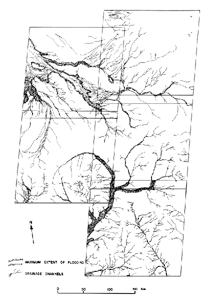 |
|---|
Another solid example of the utility of appropriately processed space imagery is strikingly portrayed in Figure 1.4. This Landsat image of block (horst) mountains and basin fill in the Mojave Desert on the California and Arizona sides of the Colorado River between Lake Mohave and an agricultural development south of Parker. It has received both computer enhancement and special photographic reproduction. The resulting color composite brings out both pronounced and subtle color tones and patterns in the alluvial fill and pediments. In some parts of the scene, individual wash or fan patterns can be traced back to immediate source rock areas. Three broad color classes of unconsolidated surface materials can be recognized: (1) light buff to tan material commonly in lower levels of the basin, (2) reddishbrown material (probably indicative of iron enrichment), and (3) dark gray to blue gray material, forming aprons around many eroding ranges and generally overlapping the first class. Although this false-color rendition departs from the normal colors observed in the field or in natural color aerial photography, it can be interpreted in terms of parent lithologies. Both the color emphasis and the interactions among alluvial of deposits emanating from the mountain uplifts are far better displayed and interpreted synoptically than has been possible from aerial photographs, even after these are joined in mosaics.
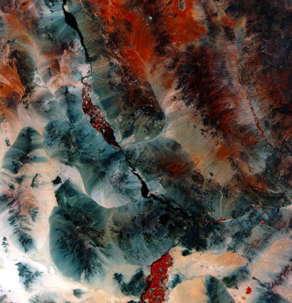 |
Figure 1.4.Landsat false-color composite (MSS Bands 4, 5, and 7 in blue, green, and red) of scene 1285-17445, Map 4, 1973, enhanced and color-printed to emphasize compositional differences among alluvial fans in the Mojave Desert around Parker, Arizona. |
|---|
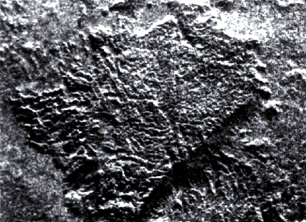
In any science, new techniques are not important of themselves. It is rather the new discoveries made possible because of those techniques that stimulate scientific progress. A profound example of such a new discovery in terrestrial geomorphology came in November 1981 when the shuttle Columbia trained a space-age instrument on the Earth. The Shuttle Imaging Radar (SIR-A) carried by Columbia produced radar images of the hyperarid Selima Sand Sheet on the eastern Sahara (Elachi et al., 1982). The radar penetrated the sand cover to reveal fluvial valleys now filled by eolian sand (Plate I-3). The valleys discovered by radar interpretation show a regional drainage system formed when the modern eolian-dominated landscape was subject to extensive fluvial erosion, probably during pluvial episodes of the Pleistocene and Tertiary (McCauley et al., 1982).
 |
 |
|---|---|
 |
 |
 |
 |
Figure 1-5. Shuttle Imaging Radar (SIR-A) images of typical Indonesian terrain, types (from Sabins, 1983). Each image is 28 km wide. The radar look direction is from top to bottom of each image. Upper left: carbonate terrain (karst topography). Upper right: clastic terrain (cuestas and hogbacks); middle left: vocanic terrain (cinder cones); middle right: alluvial terrain (river patterns); lower left: melange terrain (tectonic chaos); lower right: metamorphic terrain (high relief and angular ridges).
Geomorphological Mapping
Geomorphological mapping is discussed at length in Chapter 11. Most of the interest in geomorphological mapping has centered on the development of various mapping systems for use in environmental management (Cooke and Doornkamp, 1974), The most detailed systems have been developed in Europe, where different countries utilize different procedures (Salomé et al., 1981). Despite attempts at international standardization (Demek, 1972; Demek and Embleton, 1978), the major problem remains the correlation of various mapping schemes. Global remote sensing has great promise for generating geomorphic maps at large spatial scales.
Figure 1.5 illustrates the use of the SIR-A system to define terrain categories for geomorphic mapping in Indonesia (Sabins, 1983). The terrain types are recognized through interpretation of radar interaction with the ground surface, especially the surface roughness, vegetation, and topography. The radar information is made even more remarkable because the mapped areas are characterized by dense tropical forest cover and persistent clouds.
In 1982 in Vienna, the United States proposed at the United Nations Conference on Peaceful Uses of Outer Space that an international cooperative research program be organized to understand the Earth as a system. This program was initially named "Global Habitability" and was formulated to involve the central role by NASA in the observation of system parameters and changes (NASA, 1982). In a sense, the program constitutes a "mission to planet Earth" (Edelson, 1985) in which spaceborne remote sensing is applied to studies of dynamic processes in the atmosphere, biosphere, geosphere, and hydrosphere. The Global Habitability concept will probably be integrated into the broader efforts of the proposed International Geosphere-Biosphere Program (National Research Council, 1983) to be coordinated by the International Council of Scientific Unions.
In his keynote address to the World Conference on Earthquake Engineering, the President of the National Academy of Sciences proposed an "International Decade of Hazard Reduction" (Press, 1984). A major component of such an initiative must be the global analysis of hazardous geomorphic processes.
What do such initiatives mean for geomorphology? The following sections present some geomorphic problems that require a global perspective. A more extensive discussion of future directions in mega-geomorphology is presented in Chapter 13.
Global Tectonic and Climatic Systems
Tectonic geomorphology involves the interactions among landforms, landscapes, and tectonics. Tectonics, the branch of geology dealing with regional structures and deformation features, occupies a central role in the Earth sciences. The discipline has achieved great importance through the unifying role of the plate tectonic model in explaining the large-scale surface features of our planet.
Major advances in tectonic geomorphology have been made in the last decade, mainly because of an increased ability to evaluate the time factor in landscape development (Bull, 1984). Thus, through the use of geochemical means of dating and computerized models of landform change, it is now possible to evaluate differential rates of uplift (or subsidence). It is also possible to determine the magnitude and frequency of displacements along faults.
Perhaps the most important new development for climatic and climatogenetic geomorphology is the use of analytical models to characterize the global interactions of the land surface, atmosphere, and oceans. Most interesting are the general circulation models (GCMs) that simulate global atmospheric processes (Washington and Williamson, 1977). For climatic geomorphology, these models have shown profound feedback relationships operating between soil moisture and precipitation (Shukla and Mintz, 1982), carbon dioxide and climate (Hansen et al., 1981), and anthropogenic changes in the albedo and climate (Charney, 1975; Sagan et al., 1979). An example of an especially useful climate-genetic reference point is provided by the CLIMAP (1976) reconstruction of the 18000 years B.P. global climate from a compilation of the Earth´s ocean surface temperatures. A preliminary extension of the analysis to continental areas revealed numerous problems of local variability (Peterson et al., 1979). Such comparisons between general atmospheric conditions, as modeled by GCMs, and paleogeomorphic reconstructions hold great promise for understanding large-scale climate/landscape interactions. The goal here is to generate a self-enhancing spiral of understanding, with models pointing to key geomorphic questions and geomorphic data refining the models.
Ancient Landscapes
At the end of the l9th century, geomorphology achieved an important theoretical synthesis through the work of William Morris Davis. Davis (1899) conceived a marvelous deductive scheme of landscape development by the action of exogenetic processes acting on the basic materials and structures to produce a progressive evolution of landscape stages through time. Unfortunately, this theoretical framework was somewhat abused by those who employed it solely for landscape description and classification. By the middle of the 20th century, evolutionary geomorphology fell from favor among Earth scientists, who focused their primary efforts on the study of various geomorphic processes.
| Figure 1-6. Planation surface cut across dipping Paleozoic sandstone. James Range of central Australia |  |
|---|
An unfortunate by-product of the controversy over Davisian geomorphology was the general abandonment, especially in Britain and the United States, of studies that concerned ancient landscapes and landforms. The development of radiometric dating has rekindled interest in this topic by identifying the antiquity of landscapes. For example, Young (1983) has shown that upland surfaces in southeastern Australia originated as early as Mesozoic and Early Tertiary, with the landscape assuming its approximate present- day form by the Miocene. Twidale et al. (1974) also identified Mesozoic landscapes in South Australia.
Ollier (1979), in an analysis of ancient landscapes in Australia, concluded that conventional approaches to geomorphic change suffer from inadequate appreciation of broad scales of time and space. He proposed an evolutionary approach to geomorphic features, such as that applied by geologists to tectonic features (Windley, 1984).
 |
Figure 1-7. Landsat image of western Soutn Africa (latitude 31°45´ South, longitude 10°15´ East). The area shows the classic cyclic denudational land surfaces interpreted by King (1967). Most of the eastern (right) portion of the image is the African Surface (Table 1-4) developed on Karo System Shale, sandstone and tillite. Local high areas are Gondwana and post-Gondwana remnants. The plains to the northwest represent the Miocene Post-African Surface developed on Archean granite. Younger Quarternary valleys are dissecting this surface |
|---|
Low-relief plains cutting across varied rocks and structures are common features on the Earth. Such surfaces have long been of interest to geomorphologists, and many scientific controversies have arisen over their explanation. The genetic implications are contained in the many names for the surfaces; peneplains, pediplains, panplains, etchplains, exhumed plains, and paleoplains. To avoid the problems inherent in these controversies, it is perhaps best to simply call these features planation surfaces.
Figure1.6 shows a spectacular planation surface that bevels sandstone cuestas in the fold belt of the Amadeus Basin in central Australia. An analysis of the regional geomorphology of this area is presented in Plate I-4. The question of regional planation surfaces obviously awaits a modern global analysis. Perhaps the classic syntheses of King (Table 1-4) can be reevaluated by the use of the new techniques described in this volume (Figure 1-7). It would be refreshing to accomplish such a study with automated data collection procedures, free of the raging controversy that so hampered the highly personal interpretive studies of the past.
The identification and dating of various planation surfaces have become important components of tectonic geomorphic analysis. Deformation of such surfaces by faulting, folding, or broad warping can be calibrated by the displacement of a planation surface from its original attitude.
| Name | Age | Comments |
|---|---|---|
| Gondwana | Jurassic | Related to Pangea and its breakup. |
| Post-Gondwana or Kretacic | Early to Mid-Cretaceous | Related to Pangea and its breakup. |
| African or Moorland | Late cretaceous to Early Cenozoic | Extensive surface created by stripping weathered material from older surfaces. |
| Post-African or Rolling | Miocene | Undulating surface developed above younger valleys |
| Widespread | Pliocene | Global surface common near coastal areas. |
| Youngest | Quaternary | Latest valley formation. |
(King, 1962, 1967, 1976, 1983)
Planetary Geomorphology
Some geomorphologists hold that their science is properly restricted either to the dynamic geology or to the physical geography of the Earth´s surface. Indeed, more argument would probably be expended on the relative "geologic" or "geographic" content of geomorphology than whether any consideration should be given to bizarre alien landscapes. Such a view ignores two fundamentals. First, any science of the Earth must recognize that Earth is a planet. We learn more about that planet by studying analogs to its mysteries on other planets. Second, science derives its greatest excitement and its most important advancement through discovery.
A century ago geomorphology was a science filled with wonder and excitement. The stimulus for its rapid growth in this time period was the discovery of landscapes that then seemed as bizarre and alien as those on other planets. The great plateaus of the western United States, the hyperarid deserts of the eastern understood terrestrial processes. Sharp (1980, p. 231) emphasizes this benefit as follows:
"Planetary exploration has proved to be a two-way street. It not only created interest in Earth-surface processes and features as analogues, it also caused terrestrial geologists to look on Earth for features and relationships better displayed on other planetary surfaces."
Because many planetary surfaces have been relatively stable for billions of years, they preserve the effects of extremely rare, exceedingly violent processes. Such processes include impact cratering, sturzstroms (large avalanches of rock and debris), and cataclysmic flooding. On Earth, the evidence of such catastrophes is meager because of rapid crustal recycling through plate tectonics and relatively high denudation rates. However, on the other terrestrial planets, the results of these processes can be studied in great detail, commonly in large-area images (see Chapter 10) similar to those obtained by Earth-observing sensors in space. This is of profound importance for Earth studies. When cataclysmic processes have occurred on Earth, their influence has been profound. The extinction of numerous organisms at the end of the Cretaceous because of a meteor impact is a case in point (Alvarez et al., 1980).
The steppes of central Asia, the karst of Dalmatia, and the inselbergs of Australia and Africa all posed anomalies in the prevailing geomorphic theory. The explanation of the new landscapes led to an expanded and improved explanation for landscapes already described. Of course, this reflects an obvious quality of all science: there are no bounds, geographic or otherwise, for inquiry into the origin of phenomena. If a geomorphologist can learn more about the surface of Earth by studying other planetary surfaces, then that extraterrestrial study can no longer be dismissed as merely an interesting intellectual diversion. It becomes an absolutely essential part of geomorphology. An Earthcentered view of geomorphology is as limiting as a pre-Copernican view of the solar system.
Not all geomorphologists have shared the modern reluctance to consider the study of extraterrestrial relief forms. In 1892, the U.S. Geological Survey suffered a drastic cut in research funds. The Chief Geologist of the Survey at that time was geomorphologist Grove Karl Gilbert. Without support for his field work, Gilbert undertook a study using the U.S. Naval Observatory telescope in Washington, D.C., to compare surface features on the Moon with counterparts on Earth. Despite the prevailing view that gradual and prolonged volcanism explained lunar surface features, Gilbert (1893) concluded that cataclysmic impact processes best explained the ubiquitous lunar craters. He applied the term "meteoric" to his impact theory, which had to wait over 70 years for verification by the Apollo program of lunar landings and sample returns. Among the many lessons that geomorphology can trace to Gilbert´s example (Baker and Pyne, 1978) that of studying other planets besides Earth- has yet to be fully appreciated.
The study of planetary surfaces relies heavily on analogic reasoning to reconstruct the complex interactions of processes responsible for the observed landforms (Mutch, 1979). Thus, the photointerpreter of planetary images must rely on this experience with terrestrial landscapes. Moreover, the geomorphic interpretation of other planets produces a kind of intellectual feedback: some planetary surfaces contain excellent analogs for little
Regional landforms analysis, once termed "physiography," was the major concern of geomorphologists until the middle of this century. Landscapes and landforms were analyzed at regional and global scales in terms of their structure, processes of formation, and evolutionary sequence of development. Although regional landforms analysis continues in Europe (Embleton, 1984), it has generally fallen from favor in Britain and the United States. In the latter countries, attention in recent decades focused on the small- scale landforms and short-acting processes that were most amenable to quantitative measurement, statistical analysis, and incorporation into a systems analytical framework.
A resurrection is occurring in regional landforms studies. The impetus for this resurrection comes from many quarters. In the theoretical realm, unifying models of global tectonics and climatic systems are providing the appropriate scientific framework for large-scale studies. In the technology realm, the use of orbital remote sensing systems and geochemical tools for dating Earth history is quantifying the measurement at large spatial and temporal scales. In the discovery realm, geomorphology is being stimulated by the need to explain enigmatic landscapes, newly explored on the sea floor and on the surfaces of other planets.
Continue to Plate I-1| Chapter 1 Table of Contents.| Return to Home Page| Table of Contents|