  | |
|---|---|
 | MAP |
| |
|---|---|
| MAP |
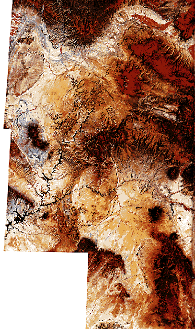
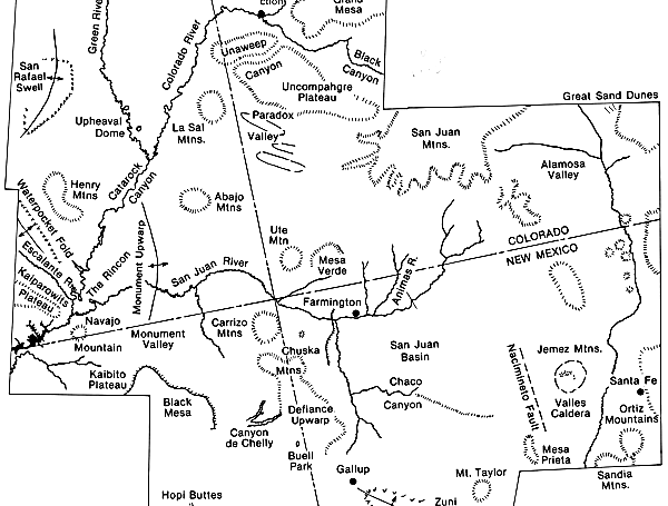
The mosaic of color Landsat scenes shows in remarkable detail the geomorphic features of the northern Colorado Plateau region of the western United States. The mosaic is centered near the "four corners area" of Arizona, Utah, Colorado, and New Mexico. The region is characterized by spectacular high desert scenery, including plateaus, deep canyons, and broad valleys with great sandstone inselbergs (Hunt, 1969). The structure is predominantly horizontal, but the sedimentary strata are locally deformed into gently dipping monoclines, broad domes, and basins.
The top center of the mosaic shows the complex relationships associated with the transition from the Rocky Mountains to the Colorado Plateau. Grand Mesa is capped by Late Tertiary basaltic lava flows. Broad upwarps were created on the plateau during the so-called Laramide Orogeny of the Early Tertiary. The folding affected drainage in many ways (Hunt, 1969). The Gunnison River, for example, cut deeply into Precambrian rock at Black Canyon. Parts of this canyon are filled with Oligocene volcanic rocks from the San Juan Mountains. Thus, the valley is 35000000 years old. At Unaweep Canyon, the Gunnison River, and probably the Colorado River, flowed through the Uncompahgre Plateau. However, continued uplift of the plateau eventually diverted the river northward. The canyon was probably abandoned in the Late Pliocene. Its floor now stands over 400 m higher than the modern Gunnison and Colorado Rivers, indicating considerable Pleistocene uplift.
Farther downstream, the Colorado River maintained its course across rising domal uplifts. The river crosses the Monument Upwarp at Cataract Canyon. The San Juan River maintained its course across the same structure. Such relationships of streams to structure are classic examples of antecedence.
| Figure I-1.1 | Figure I-1.2 |
|---|---|
 |
 |
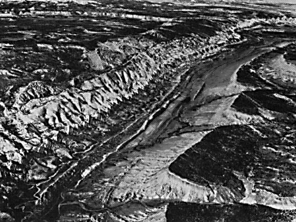
Several major deformational structures are spectacularly displayed by differential erosion of the exposed sediments. Waterpocket Fold (Figure I-1.1) is an excellent example of a monocline. Paradox Valley, just east of the La Sal Mountains, is an anticlinal structure that formed by the intrusion of plastically deformed bedded salt of the Permian Paradox Formation. The San Rafael Swell exposes Pennsylvanian sandstone and carbonate units in its core. These are surrounded by great cuestas of dipping Triassic and Jurassic sandstone and shale units. Uplift of the swell began in the Early Tertiary but continued for a prolonged period, as indicated by arched Tertiary formations at the north fold's northern end.
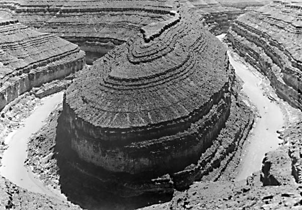
Note that the Colorado and Green Rivers have pronounced incised meanders upstream of their confluence. In this area, they are flowing upstructure (i.e., against the regional dip). In Cataract Canyon, the river becomes much less sinuous as it crosses the crest of Monument Upwarp. The San Juan River shows a similar phenomenon as it approaches the Monument Upwarp (Figure I-1.2). This results in the famous "gooseneck" (Figure I-1.3). Farther downstream, the Colorado River displays a spectacular cutoff meander, the Rincon, where it crosses the Waterpocket Fold.
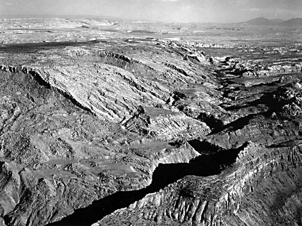
The region near the Colorado/Green junction is known as the Canyonlands section. The rivers have an inner gorge about 150 m deep (Figure I-1.4), developed in Upper Paleozoic rocks. A broad bench is developed on the Permian Cutler Formation. Triassic and Jurassic shale and sandstone units have retreated over 10 km from this inner gorge to form the bench. Charles Hunt (1969) suggested that the upper bench formed over a long period, extending back to at least the Miocene. The inner canyon is believed to have formed since the late Pliocene, and presumably, about three-quarters of the depth was achieved in the Quaternary.
| Figure I-1.3 | Figure I-1.4 |
|---|---|
 |
 |
Prominent laccolithic domes (Gilbert, 1877) are responsible for several of the mountain areas in the southwestern part of the mosaic. These include the Henry Mountains, Abajo Mountains, La Sal Mountains, Navajo Mountain, Ute Mountain, and the Carrizo Mountains (Hunt, 1956). Doming generally occurred in the Early Miocene about 25 million years ago. Unlike the Laramide fold structures, the major rivers do not cross these domes. Rather, they flow around the large igneous structures. The domes are drained by radial patterns of streams.
The right portion of the mosaic shows the Rio Grande depression, a series of downfaulted grabens between the Colorado Plateau and the Sangre de Cristo Range of the southern Rocky Mountains. The Ortiz Mountains and Sandia Mountains are fault blocks in this portion of the basin and range province. A prominent fault marks the western boundary of this zone at the Nacimiento Mountains.
The spectacular Valles Caldera was produced by cataclysmic Pleistocene eruptions of ashflow tuffs. Subsidence after the eruption was followed by resurgence as more lavas entered the caldera to form a ring of small domes.
The San Juan Mountains, at the northeastern margin of the plateau, consist of older Tertiary ashflow tuff units. Deep erosion highly modified the original volcanic structures. Glacial troughs and cirques occur at the highest elevations, which were extensively glaciated during the Pleistocene.
The San Juan Basin, immediately south of the mountains, contains a thick fill of Cretaceous and Tertiary rocks. At Chaco Canyon, the drainage has breached Chaco Cuesta, a sandstonecapped cuesta. Mesa Verde exposes littoral- marine Cretaceous sandstone capping a thick sequence of Mancos Shale. The sandstone cliffs at both Mesa Verde and Chaco Canyon were highly desired occupation areas for the Anasazi culture of Indians approximately 1000 years ago.
Among the younger volcanic fields of the Colorado Plateau are the Hopi Buttes, a swarm of cones and eroded volcanic pipes of Tertiary age. Mount Taylor comprises a stratocone reaching 3340 m (11300 ft) in elevation. Its volcanic field also includes a basalt-capped mesa (lower right of the mosaic) and a prominent outlier, Mesa Prieta. The volcanism was Late Tertiary in age.
The mosaic also shows some interesting small circular structures. Buell Park, at the bottom center, is a caldera-like basin eroded from soft volcanic tuff at the crest of the Defiance Upwarp. It is one of more than 30 volcanic explosion pipes (diatremes) that have been recognized nearby. Upheaval Dome, near the Green River in the upper left of the mosaic, was once thought to be the result of salt deformation, similar to the origin of the Paradox Basin. This structure has recently been reinterpreted by Eugene Shoemaker, who finds it to conform to the expected properties of a deeply eroded astrobleme. As much as 2 km of overlying beds may have been removed by erosion since the impact, which Shoemaker infers to be latest Cretaceous or Paleocene in age. The original crater may have been 10 km in diameter before its modification by deep erosion. The required impacting body would have been on the order of 500 m across.
Continue to Plate I-2| Chapter 1 Table of Contents.| Return to Home Page| Complete Table of Contents