 |
 |
|---|---|
| Plate T-23 | Map |
|
|
|---|---|
| Plate T-23 | Map |
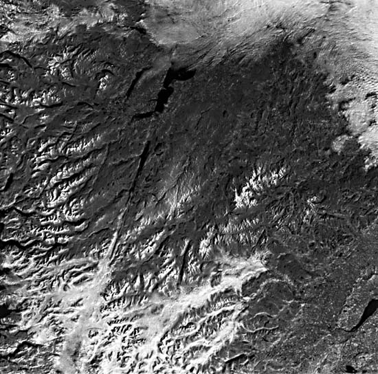
The topography in this scene of northwestern Scotland is deceptive because it suggests relatively simple underlying geology (Price, 1976). In fact, the Plate fails to reveal some very interesting aspects of this region that is so important to the development of geologic concepts. Here, G. Barrow first arrived at his concepts of metamorphic zones and index minerals in the Dalradian schists. The region is also noted for excellent exposures of ring dikes and cauldrons and its assemblages of Precambrian and Lower Paleozoic crystalline rocks. It is also the type of locality for the Caledonian orogeny. The Highlands can be correlated with the Scandinavian Highlands (Norway) and the northern Appalachians, which once formed a continuous belt before the breakup of Pangaea.
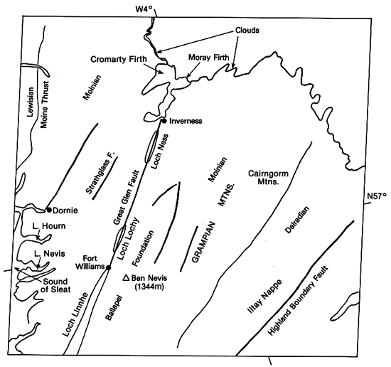
In the Plate, the most prominent topographic feature is the long linear depression along which several lakes, including Loch Ness (Figure T-23.1), are aligned. This feature is a valley developed in a l-km wide zone of weakness associated with the Great Glen fault (Anderson, 1978). Devonian rocks in the valley suggest that it is quite ancient (initial erosion must be Pre-Devonian). The fault is left-lateral transcurrent with a cumulative horizontal displacement of 104 km (with some vertical movement). The Great Glen fault separates two geomorphic units, the Northern and the Grampian Highlands. The southeast edge of the latter lies along the Highland Boundary Fracture Zone, a normal fault that borders the Midlands graben.
| Figure T-23.1 | Figure T-23.2 |
|---|---|
 |
 |
Precambrian assemblages comprised a craton against which much of the Caledonian tectonic activity was directed (Anderson, 1978). The Caledonian Front is marked by the Moine thrust (roughly along the left edge of Plate). Behind the Front, the rocks of the Highlands consist mainly of the Moine schists (Late Precambrian, with some activity perhaps as young as 410 Ma) distributed about equally on either side of the Great Glen fault. West of the fault, the terrane is sliced by a series of westward-directed thrust sheets associated with autochthonous nappes, which impart a northeast lineation to the topography. Valley adjustment is guided by these faults. These sheets consist of Lewisian, Torridonian, Moinian (mostly metasedimentary), and some Cambrian units; most displacements carry older rocks over younger ones. In parts of this subregion (e.g., around Inverness) are deposits of Devonian Old Red Sandstone, moderately deformed, that rest unconformably on the older metamorphic assemblages.
The Late Precambrian-Cambrian Dalradian metamorphic rocks occupy roughly the eastern third of the Grampian Highlands. In the Grampian Highlands, in addition to Moinian and Dalradian units and deformed Old Red Sandstone beds, there are remnants of sediments laid down in the Carboniferous, Permo-Triassic (New Red Sandstone), and the Lias. Structurally, the older metasedimentary rocks (and the underlying Lewisian units) were affected by at least three or four major folding phases, commencing probably in Mid-Ordovician and culminating with the first stage of the Caledonian orogeny in Late Silurian that continued into Late Devonian. Kyanite and sillimanite grade metamorphism affected all older rocks.
The landscape of the Highlands (Embleton, 1984) is rugged, bleak, and strangely beautiful. The highly dissected terrain indicates great differences in rock resistance. Steep- sided towers of Torridonian sandstones, as well as cuestas and plateaus cut from other rocks, add diversity to the vistas (Figure T-23.2). The mountain on the right, towering above the exhumed SubTorridonian surface of low relief, is an erosional remnant, an outlier of the Moine thrust. Bare rock is common, with a cover of forests, heath, and brush. Rounded knobby hills and monadnocks and mountain ranges above 1000 m alternate with low moors. The land was largely covered by Late Pleistocene glacial ice. The high plateau area has been glacially eroded to form cirques, arêtes, sharp ridges, and broad glacial troughs, many of which are filled by lakes. Many valleys are ice-sculptured weak zones along faults. Fjord-like inlets (firths) on the west coast are also ice cut.
| Figure T-23.3 |
|---|
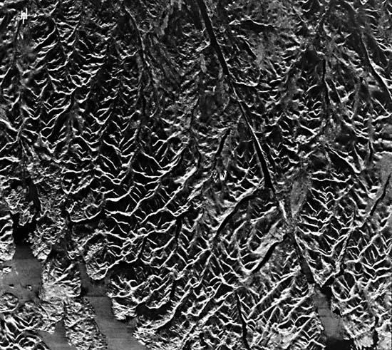 |
A Seasat radar image (Figure T-23.3) of the Fort Williams area gives another perspective on the narrow ridges and valleys imposed on the resistant Moine rocks. (NMS) Landsat 1233-10564-7, March 13, 1973.
Continue to Plate T-24| Chapter 2 Table of Contents| Return to Home Page| Complete Table of Contents