 |
 |
|---|---|
| Plate T-27 | Map |
|
|
|---|---|
| Plate T-27 | Map |
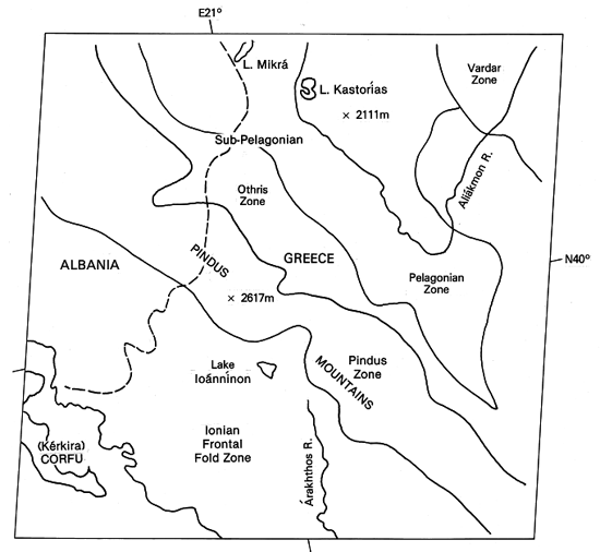
This scene depicts another segment of the complex tectonic terrane that makes up the alpine mountain system. The Dinaride Alps (Plate KL-5), run southeast along the western side of the Balkans and pass through Yugoslavia into Macedonia, where they join the Hellenide segment. The Plate image shows the Pindus Mountains of central and northwestern Greece (Epirus Mountains in Albania).
Following the breakup of Pangaea, there were several microplates between the Eurasian, African, and Arabian plates. During the Mesozoic and Cenozoic convergence, the microplates were caught between the major plates and underwent a complex series of deformations in the Eastern Mediterranean. The Italo/Adriatic plate moved eastward against the Balkan segment of the Eurasian plate to create the Dinaric orogenic belt. To the south, various microplates (e.g., the Messina, Macedonian, Ionian, Aegean, Turkish, and Levantine plates) became involved along subduction and transform boundaries. The Macedonian microplate that underlies the terrain appearing in the Plate image is bounded on the west and north by suture zones.
| Figure T-27.1 | Figure T-27.2 |
|---|---|
 |
 |
As in much of the western Alps, the developmental sequence in the southern Balkans began with rifting, release of flood basalts, and formation of new crust in the Triassic. This was followed by building of platforms in the Jurassic, on which shallow carbonates accumulated, that were separated by deeper water basins containing pelagic (radiolarian) sediments and extensive flysch deposits. Then, convergence of plates started in the Cretaceous with destruction of oceanic crust (ophiolites) at trenches, closure of marginal basins, and formation of thrust belts, nappes, and metamorphic zones during general closing and collision between Europe and Africa, which continued into the Oligocene. Deformation continues to the present (Dewey and Sengor, 1979).
A series of tectonic zones trend roughly north-northwest across this part of Greece. Because most zones are actually thrust sheets, thrust faults form the zone boundaries. Most fault planes dip eastward, with westward directions of tectonic transport (shortening of 130 to 200 km) imposed when oceanic crust was consumed under the continental plate along the east-dipping subduction zone. These tectonic zones contain sedimentary rocks and associated oceanic basalt flows of the types found in depositional troughs along active plate margins: the deposits have been telescoped into imbricate slices within the zones (Temple, 1968).
The index map names and delineates these zones as defined by Zimmerman and Ross (1976). In general, rocks are older and more metamorphosed to the east. The Pindus zone (high mountains and rough texture) is an allochthonous block separated from the Frontal Folds by a shallow-dipping (30°) thrust fault that extends from northern Albania to the southern Peloponnesus. The block itself is cut into numerous slices by subsidiary thrusts that further offset tight folds and nappes. The High Pindus Mountains reach elevations above 2000 m. A fenster (scene center) exposes underlying frontal zone strata. The Othris (sub-Pelagonian) zone, whose western margin is another sole thrust, is an old oceanic trench that contains Cretaceous ophiolites and mélange underlying Tertiary molasse deposits and overlying siliceous oceanic sediments. The Pelagonian zone, which includes Cretaceous volcanic, metamorphic, and sedimentary rocks, probably represents an island arc that was caught up in the complex subduction.
| Figure T-27.3 |
|---|
 |
The most remarkable attribute of this scene is the close correlation between the individual structural zones (mostly imbricated thrust sheets) and the differences in their geomorphic expression. In the image, one is immediately impressed by the variability of these allochthonous terrains in terms of variations in slope and relief, drainage texture, and tonal changes. This can probably be quantified by measurements of such parameters as stream or divide lengths, densities, and orientations. The important point is this: the landforms themselves express the structural configuration and lithologic makeup of each zone and graphically display the tectonic framework of the entire deformed belt.
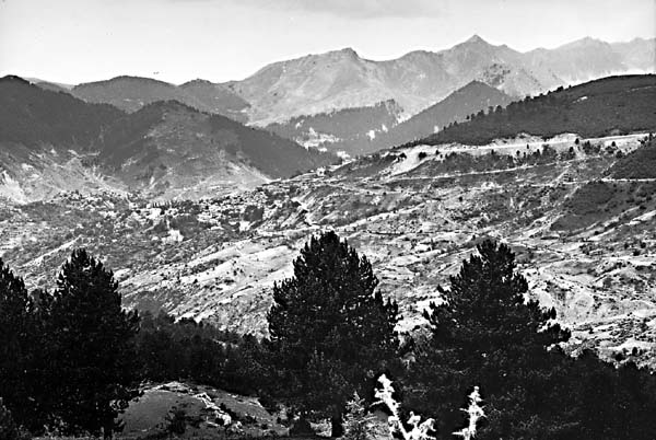
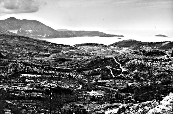
Ground views help to give a "feel" for these distinctive terrains. Figures T-27.1 and T-27.2 portray allochthonous blocks and imbricate slices as landforms in the Greek Pindus Mountains. In Figure T-27.3, jumbled terrain has been cut from an autochthonous block of Cretaceous limestones in the comparable Dinaride Alps in southern Yugoslavia (see Plate KL-5). (NMS) Additional References: Demek et al. (1984), Zimmerman (1972), Zimmerman and Ross (1976). Landsat 1102-08491-7, November 2, 1972.
Continue to Plate T-28| Chapter 2 Table of Contents| Return to Home Page| Complete Table of Contents