 |
 |
|---|---|
| Plate T-28 | Map |
|
|
|---|---|
| Plate T-28 | Map |
The Ural Mountains are an excellent example of deformation associated with collisions of two continents, and they bear a striking resemblance (structurally, and to some extent, morphologically) to the Appalachians. They form a continuous belt 150 to 300 km wide and more than 4000 km long. Beginning near 48°N latitude, they run nearly parallel to 60°E longitude until they deflect northeastward (Polar Urals), then northwestward (Pay Khay), then northeastward again through Novaya Zemlya. They are overthrust to the west and cover the eastern part of the little deformed Russian (East European) platform. On the east, they abut the West Siberian lowlands, which contain mildly deformed post-Paleozoic sedimentary rocks, now largely covered by Quaternary deposits.
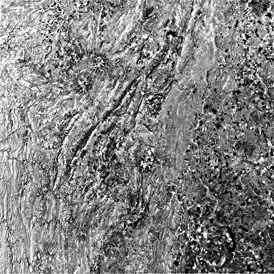
The Plate covers part of the widest zone of the South Urals, just northwest of the industrial city of Magnitogorsk. The mountains here reach 1663 m (at A), with relief of 400 to 500 m. In the western half, elongate ridges predominate; those near the scene edge are part of an anticlinorium made up of Middle Paleozoic sedimentary rocks. Rivers anomalously cut across these folds through water gaps controlled by faults. The easternmost edge of the slightly folded Permian rocks (in the Cis-Urals) crosses the upper left corner of the scene. Rocks in the central section of the image are mainly Late Proterozoic and Early Cambrian metasediments. A fault zone near Beloretsk (an iron-mining center) separates the central Urals (part of the miogeosynclinal segment) from the eugeosynclinal Trans-Urals to the east. These eastern rocks range from Ordovician to Carboniferous age. Middle Paleozoic (Caledonian) ultrabasic rocks near Beloretsk and synorogenic (Hercynian) intrusive granite massifs farther east intrude these units. Much of the Trans-Urals is now eroded to a surface of low relief, much like the Piedmont of the eastern United States. Erosion of the crystalline rocks presents quite a different topographic texture (as seen in the aerial oblique photograph of the Urals (Figure T-28.1)) than erosion of the dipping sedimentary rocks.
| Figure T-28.1 | Figure T-28.2 |
|---|---|
 |
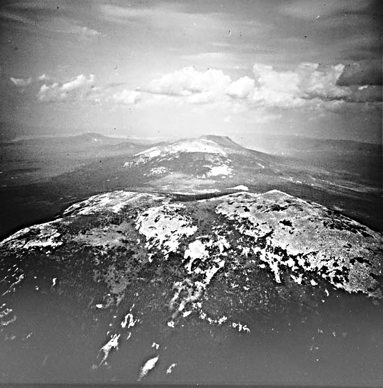 |
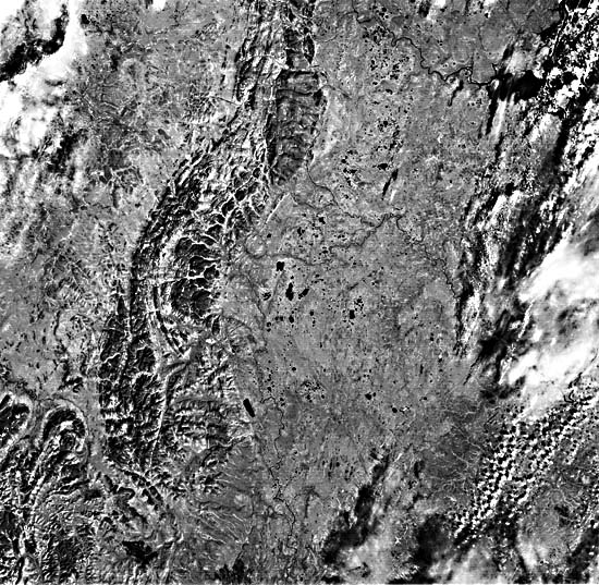
Figure T-28.2 (a Landsat MSS scene) shows a segment of the Polar Urals near 65°N where the mountainous terrain narrows to a belt only 50 km wide that contains (oceanic) ultramafics rocks and granites intermixed with Proterozoic to Ordovician rocks. To the right are plains of Quaternary sediments and glacial cover drained by the Synya and Voykar Rivers that empty into the Ob River (upper right) (see Plate KL-8).
The Urals are the western side of a wider zone of deformation, the Uralides, which underlie the West Siberian platform (a foreland basin) and eastward crop out again along the western edge of the Siberian platform. The Uralides underwent maximum deformation during the Late Paleozoic (Hercynian time) as the Russian and Siberian continents converged and sutured, sweeping up island arc and other essentially oceanic fragments caught between them (evidenced by spilites, radiolarian cherts, and other ophiolitic assemblages). Convergence during the Hercynian produced folding that diminishes to the west, along with strong westward thrusting of slices of the eugeosynclinal rocks onto the western shelf. (The two terranes meet along the Main Uralian fault, a shear zone up to 20 km wide.) Right-slip faulting deformed the Variscan basement and indicates either nonorthogonal convergence or an earlier period of deformation.
| Figure T-28.3 |
|---|
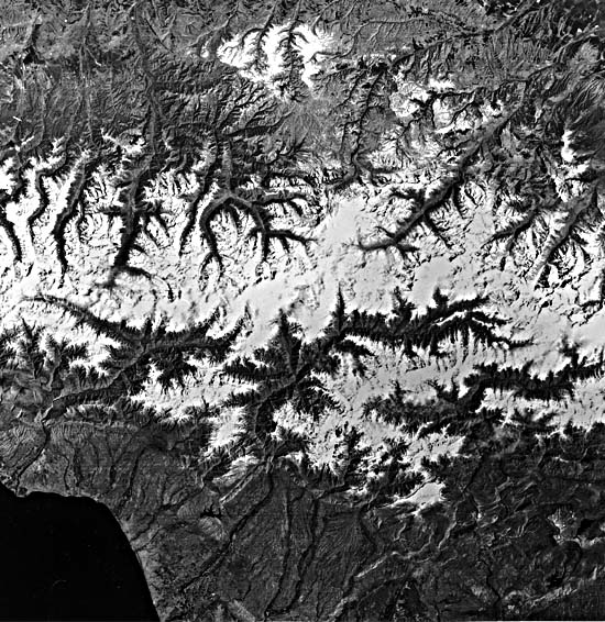 |
Figure T-28.3 covers another of the best known orogenic complexes in the Soviet Union. The Great Caucasian chain, or Caucasus, is a northwest-trending orogen that lies along the northeast segment of the Mediterranean geosynclinal belts, which includes the Alpine, Carpathian, Hellenide, and Anatolian mountain systems. Rocks from Precambrian through Tertiary/Quaternary ages are exposed in the Caucasus, with Jurassic and Cretaceous units reaching thicknesses of 15 km or more. Two major epochs of deformation have shaped the modern Caucasus: the Kimmerian (Upper Triassic/Lower Cretaceous), in which the Caucasian anticlinorium was produced, and the Alpine (Cenozoic), in which earlier tectonic structures were, and still are, being further deformed. The Caucasus now has heights exceeding 5000 m (Mount Elbrus = 5633 m), which fostered a well-developed system of glaciers in the Pleistocene. Parallel drainage systems flowing northward form an incipient trellis pattern. (NMS) References: Bashenina (1984), Dumistrasko (1984), Hamilton (1970), Nalivkin (1960). Landsat 2922-06040-7, August 1, 1977.
Continue to Plate T-29| Chapter 2 Table of Contents| Return to Home Page| Complete Table of Contents