 |
 |
|---|---|
| Plate T-36 | Map |
|
|
|---|---|
| Plate T-36 | Map |
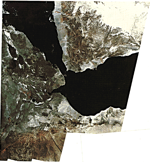
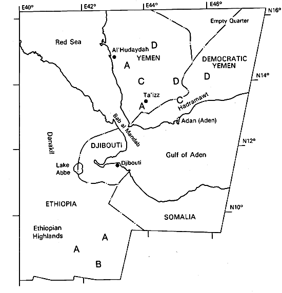
This mosaic displays the incipient breakup of a continent along rifts with concomitant invasion of magmas to form new oceanic crust. Indeed, this scene is the outstanding example of a growing spreading center and a rift/rift/rift (RRR) triple junction. The rift arms -the Red Sea, the Gulf of Aden, and the Ethiopian section of the East African Rift-diverge from a center near Lake Abbe. The first two separate Africa from Arabia, whereas the third, the African Rift, seemingly initiates splitting of the continental crust of northeastern Africa. As a consequence, Arabia moves to the northeast, bounded on the northwest by the Dead Sea Rift zone and the Owen/Quetta/Chaman Fault zone to the southeast, to collide with Eurasia along the Zagros Mountains of Syria, Iraq, and Iran along a northeast front. Easternmost Africa appears to be separating eastward along the East African Rift, but movement is very slow and is hindered by westward spreading from the Carlsberg Ridge in the Indian Ocean.
Precambrian rocks (reddish brown in the mosaic (A)), once part of a single shield, border the rift arms and rise to + 3000 m along abrupt scarps to form the Ethiopian (west) and Somalian (east (B)) plateaus and the mountains of Yemen (C). Old erosion surfaces and capping Mesozoic rocks (lighter areas in Yemen (D)) slope away from the rift. Tertiary and Quaternary extrusive rocks fill the Afar Depression at the intersection of the three rift systems. Here, elevations vary from + 1000 to -100 m. Alkali salts and eolian sand fill some of the lower areas and appear white against the dark-gray and black lavas on the mosaic.
Thermally driven uplift and domal arching of the crust began in the Oligocene (perhaps earlier), accompanied by attenuation and eventual rifting in the Gulf of Aden and Red Sea regions. Lateral spreading of ascending mantle material helped to generate linear or axial zones of weakness along which rifting progressed. Early stages of volcanism (Eocene) extruded alkalic basalts of the Trap Series (150000 km3) that range in thickness from a few hundred to 2000 m. Somewhat later, an extensive (thickness >4000 m, volume 120000 km3) series of flood basalts filled the protorift trough within the Afar. By the Miocene, alkali olivine basalts poured from large shield volcanoes at various local centers, releasing up to 70000 km3 of widespread extrusive material. Some extrusions were peralkaline in the Pliocene. Many of the deposits resulted from violent eruptions that discharged large volumes of silicic welded tuffs both on plateaus and in rifts. Rifting in Ethiopia and southward began in the Miocene and intensified in the Pliocene. Eruption of oceanic tholeiites began in Middle Miocene and became the dominant rock type erupted through the Holocene. (Some peralkaline activity continued.) True oceanic lavas, confined mainly to the oceanic rift arms, were first emplaced from 25 to 15 Ma ago. The median troughs of the Gulf of Aden and Red Sea reached widths of 200 and 50 km, respectively. Although neither rift floor has evolved into a spreading ridge, transform faults cut the proto-oceanic crust of the Gulf. This crust shows some magnetic polarity striping from which a spreading rate of 2 cm/year has been calculated.
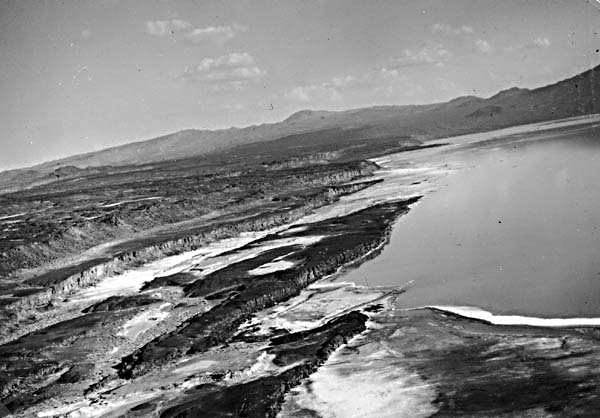
Deformation within the Afar Triangle (Plate V-21) tends to be greatest adjacent to the margins of the rift (marked by bold scarps). Faults of large throw control the inner boundary of the margins. These zones contain marginal grabens, 4 to 6 km wide, offset by cross-rift transcurrent faults. On its east side, the Afar Triangle is separated from the Red Sea and Gulf of Aden by the Danakil and Aysha horsts, strongly deformed blocks of Precambrian and Mesozoic rocks now largely covered by Afar volcanic rocks. Many normal fault belts trend northwest parallel to the Red Sea across the eastern portion of the Afar. Northeast transcurrent faults and associated secondary en echelon faults cut the floor of the main rift (Figure T-36.1).
| Figure T-36.1 | Figure T-36.2 |
|---|---|
 |
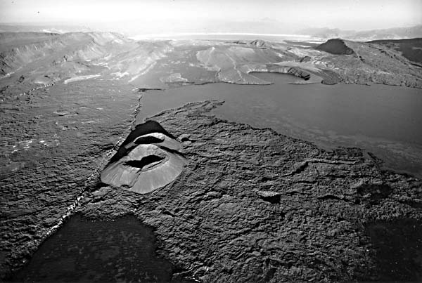 |
In the Afar, Holocene volcanic cones, mostly of silicic composition, lie on tensional crest lines (Figure T-36.2). These axial ridge volcanoes line up in the central zone along an extension of the Wonzi fault belt that occupies the middle of the Ethiopian Rift zone to the south. The structural trend of this rift is north-northeast, but en echelon fault displacements give it an apparent northeast trend in the topography.
| Figure T-36.3 |
|---|
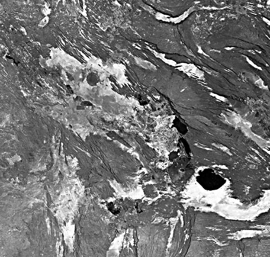 |
Figure T-36.3, a Landsat image of the Danakil Depression northwest of Djibouti, shows details of the complex pattern of recent volcanic flows (black), salt deposits in depressions (white), and large numbers of small normal faults. From the pattern, it is easy to visualize the crust stretching, faulting, and spreading with magma oozing up through the fractures to form flows and volcanoes. (GCW: H. Blodget) References: Al-Shanti (1979), Bannert (1972), Greenwood and Bleackley (1967), Mohr (1970). Landsat Mosaic.
Continue to Plate T-37| Chapter 2 table of Contents| Return to Home Page| Complete Table of Contents