 |
 |
|---|---|
| Plate T-45 | Map |
|
|
|---|---|
| Plate T-45 | Map |
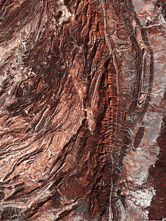
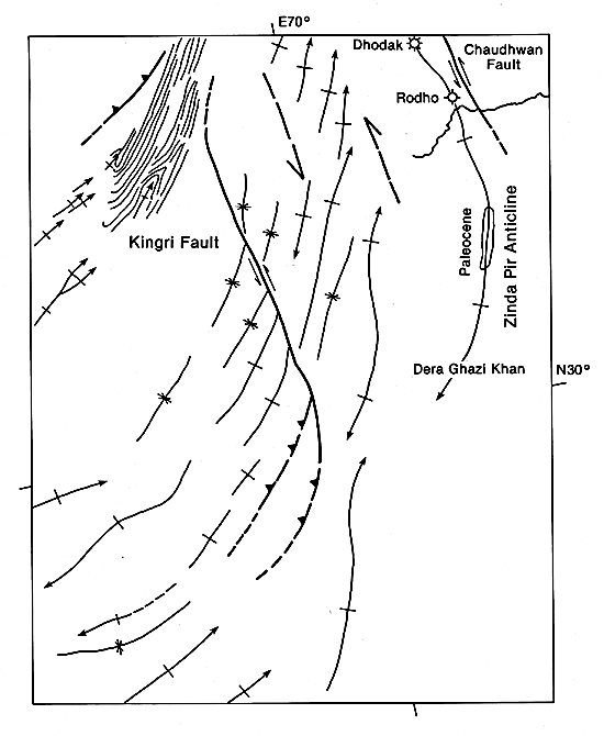
As the Indian subcontinent drifted northward, eventually creating the mighty mountains of the Himalaya, the subcontinent also had to push aside the continental blocks to the east and west. The ensuing oblique collision between the Afghan block and the Indian subcontinent formed the Kirthar and Sulaiman Ranges of Western Pakistan. The latter range is partially shown in this Plate, itself the eastern two-thirds of a full Landsat scene. As the mosaic of Pakistan (Plate T-43) shows, the Sulaiman Ranges are oriented north-south, ending southward in a festoon-shaped arc. In this arc, folds and faults are locally associated with strike-slip faults. A good example of such an association can be seen in this Plate. Folds and thrusts at the southwestern end of the Kingri fault (Rowlands, 1978) transfer their compression into sinistral slip along the fault (see index map). The folds on either side of the Kingri fault cannot be correlated across the fault, suggesting that they formed during faulting.
Earthquake studies (Quittmeyer et al., 1984) demonstrate that two recent earthquakes originated in the superficial structures seen in this scene, whereas two other recorded earthquakes resulted from thrusting in the basement. Such a differentiation between earthquakes is only possible when the upper layer of the crust has detached itself from the basement.
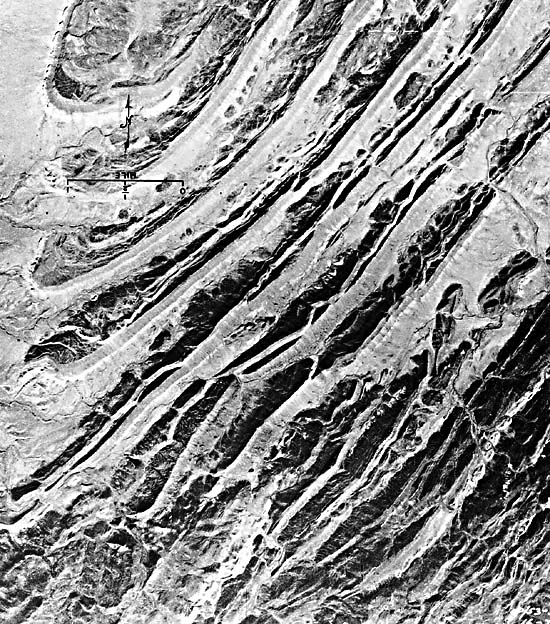
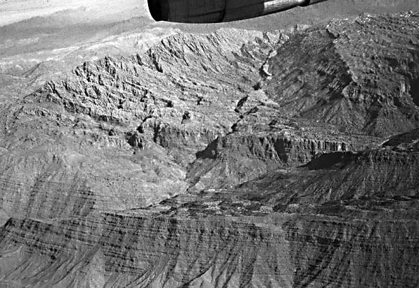
The regional structure also indicates that the Kingri fault and associated folds are the result of detachment; the structure is indeed similar to that of other thrust and fold belts characterized by detachment. Typical are the absence of basement rocks at the surface, the similarity between nearby folds, and the presence of imbricate fault structures in the northwest corner. There, light-colored limestone and marl overlain by dark-colored sandstone, both of Cretaceous age and with a total thickness of less than 330 m, have been imbricately thrust into a repetition of at least 20 steeply dipping, fault-bounded panels that later were folded. This remarkable structure (Figure T-45.1 and Figure T-45.2) plunges to the northeast, thus revealing broad folds of Jurassic rocks in the southwest beneath the detachment plane. The imbrication of the Cretaceous rocks is contemporaneous with the obduction of the ophiolites shown in the Zhob Valley Plate, while the folds in the Jurassic rocks, most other folds shown in this Plate, and the Kingri fault are of Late Tertiary/Recent age. Some of these young folds display an en echelon arrangement indicating a southward slip of the detached layer with respect to the foreland. Farther east, the gently curved Zinda Pir anticline reflects transport to the east, but next to the fold is the left-lateral Chaudhwan fault (Kazmi and Rana, 1982), emphasizing the close relations between compressive features and strike-slip faults in this area.
| Figure T-45.1 | Figure T-45.2 |
|---|---|
 |
 |
The festoon shape of the Sulaiman fold belt, together with the en echelon fold structures along its flanks, suggests that indeed the entire lobe is a thin-skinned structure moving along a deeper décollement surface. Thick Infracambrian evaporates, probably correlative to the Hormuz salts of Iran, are present in the near surface within 250 km east of the Sulaiman fold belt. It is likely that a westward extension of these salt units provided the detachment surface for the apparent décollement movements. The southward décollement movement has not occurred across the northerly striking Sibi Trough, a portion of which is seen as the high area in the lower center of the Plate. Indeed, it is the lack of movement within this area, coupled with the extensive southward movement of the fold belt to the east, that gives much of the Sulaiman belt its distinctive festoon shape.
The successive breaching of the multicolored Tertiary formations of the Zinda Pir anticline reveals in its core the same Paleocene rocks that host the gas in the Sui anticline (southernmost anticline in Figure T-44.2). These rocks were the prime target in two wells drilled in the northern end of the anticline where the Paleocene formations had plunged beneath a cover of younger Tertiary rocks. The Dhodak well discovered a giant gas and gas condensate field in 1976; 9 years later this field has not yet been brought into production, in part because of the extremely difficult access to the Sulaiman Range. (GCW: K. A. DeJong) Landsat 30283-05144, December 13, 1978.
Continue to Plate T-46| Chapter 2 table of Contents| Return to Home Page| Complete Table of Contents