 |
 |
|---|---|
| Plate T-46 | Map |
|
|
|---|---|
| Plate T-46 | Map |
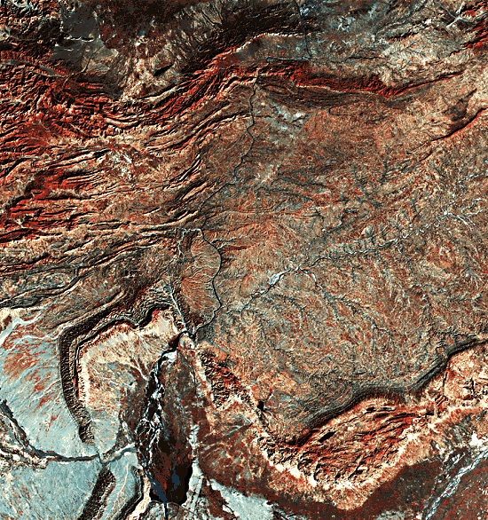
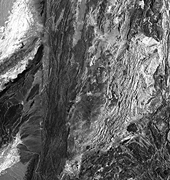
This Plate shows the western terminus of the foothills of the Himalaya Mountains. Farther west is the sinistral Chaman Fault (Figure T-43.3), along which the Indian subcontinent moved northward, and to the north are crystalline and Paleozoic formations underthrust by the subcontinent during the Cenozoic. The detachment fault climbs stepwise to the surface and ultimately reaches the surface south of the Salt Range (A) and Surghar Range (B). The two ranges are connected by a dextral strike-slip fault system (C), indicating that movement was in a south-southeast direction. The detachment fault steps upward from a Precambrian or Cambrian salt layer comparable to the Hormuz Salt in Iran. The salt is exposed in the Salt Range, where folds are due to tectonic transport (D) and to salt flowing toward river valleys (E). Other morphotectonic features include topographic breaks related to normal faults (F) visible just north of the valley anticlines.
The abundance of low mountain ridges in Kohat and their absence in Potwar shows a fundamental difference between the structure of the two regions. The ridges are formed by Eocene limestone, and the relatively flat areas by the molasse of the Murree and Siwalik Formations are of Miocene/Pliocene age. The ridges in Kohat indicate the presence of folds or, less commonly, thrust faults formed by detachment and folding of Eocene and younger formations along an evaporite and shale sequence of Middle Eocene age. That sequence is restricted to the Kohat area, which explains the differences in topography and structure between Kohat and Potwar.
| Figure T-46.1 | Figure T-46.2 |
|---|---|
 |
 |
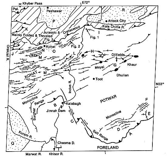
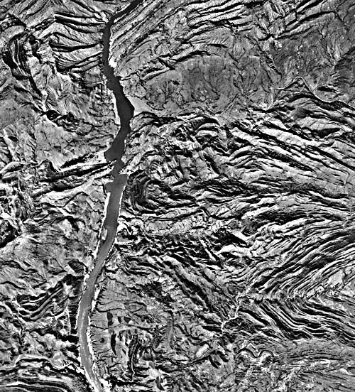
The broad folds (G) of the molasse in southwest Potwar involve Mesozoic rocks at depth, and the Dhulian and Khaur brachyanticlines are apparently underlain by pillows of Precambrian/Cambrian salt. The folds in the northwest Potwar are strikingly different. Two recent wells (H) in surficial synclines of Upper Murree rocks bottomed in anticlines of Lower Murree and older rocks. This disharmony is the result of a detachment zone within the Murree Formation, the presence of which can be deduced from observations in the northwest Potwar south of the Kala Chitta Range. There, the Upper Murree has been folded in three synclines (I) (Figure T-46.1), of which the northern one is partially overthrust by units of the Kala Chitta Range. The Lower Murree is also folded, but the wavelength of these folds, as shown in this Plate, is much smaller than that of the three synclines. This disharmony can be explained by the presence of a detachment zone in the Murree Formation. Another example of disharmonic structure can be found west of the Kohat Plateau. Looking eastward at an angle of about 30°, one sees major thrusts in the Orakzai Mountains (J) below the folds of the Kohat Plateau (K). The Orakzai thrust faults apparently coalesce in the Eocene shales, thus forming a roof thrust with a duplex underneath.
| Figure T-46.3 |
|---|
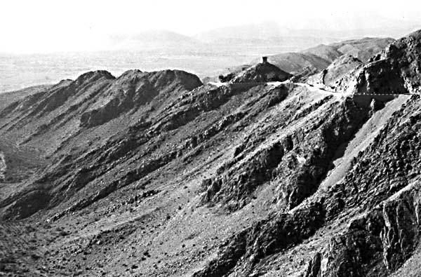 |
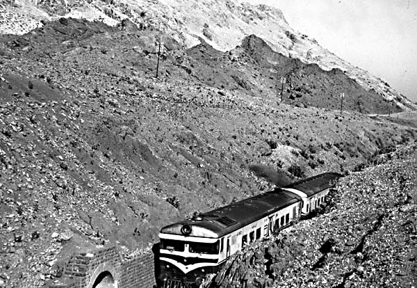
In general, Middle Eocene shales, gypsum, and salt in the Kohat anticlines are overlain conformably by the younger layers. The gypsum and salt form ridges that rose to the surface concomitant with the folding that began during deposition of the Siwalik sequence, with most of the deformation occurring in the Early or Middle Pleistocene. The folds consist of shale and evaporates overlain by Eocene limestones and shales, then sandstones and conglomerates of the molasse. In the semiarid climate, the limestone weathers out to form high ridges (L) (Figure T-46.2). The largest such feature is a tectonic klippe in the Surgul syncline (M). The klippe of Eocene limestone, which slid southward from the Buraka anticline, is folded in the neighboring syncline so that displacements must, therefore, have occurred early in the folding process. During folding, the anticlines flattened, overturning fold limbs such as those west of the city of Kohat, which include a syncline (N) in which an artificial lake is located. This lake irrigates an area that is a recent tectonic depression (Figure T-46.3, as seen from the Kohat Pass) filled by alluvium thousands of meters thick (0). Other large recent tectonic depressions, also characterized by extensive irrigation, include the plains of Peshawar (P), Bannu (Q) and Attock City (R). (GCW: K. A. DeJong) References: DeJong (1981), Gornitz and Seeber (1981), Meissner et al. (1974), Yeats et al. (1984). Landsat 20691-04550, December 13, 1976.
Continue to Plate T-47| Chapter 2 table of Contents| Return to Home Page| Complete Table of Contents