 |
 |
|---|---|
| Plate T-57 | Map |
|
|
|---|---|
| Plate T-57 | Map |
The Flinders Range is an orogenic belt developed from the Adelaide rift, a large depositional basin containing a thick (15000 to 20000 m) section that records accumulation of sediments from about 1400 to 550 Ma ago. The rift opened first to the north and later to the south. The accumulation in the basin probably constitutes the most complete section of Middle to Upper Proterozoic rocks in the world. Geographically, this is part of the Highland Chain that runs through the state of South Australia from the Musgrave Ranges in the northwest and the Peake and Dension Ranges (north), southward through the Flinders Range, to the Mt. Lofty Range that lies east of Adelaide, and on to Kangaroo Island. The Plate shows the Northern Flinders Range. Most of the Flinders and Mt. Lofty Ranges stand at altitudes from 700 to 900 m (highest peak at 1165 m), with internal relief of 200 to 400 m; the Arrowie basin (east) and Lake Torrens Plain (west) have surfaces that are mainly below 300 m.
Structurally, the Hinders Range is a giant horst block rising above graben blocks on either side. Internally, the range is a refolded fold belt. Lake Torrens to the west is situated on the east side of the Stuart Shelf, a crystalline block (less than 2 km to basement) covered by mainly undisturbed Proterozoic sedimentary rocks and bounded to its southwest by the higher Gawler Block of Early Proterozoic rocks, which are actually a continuation of the ancient shield underlying much of Western Australia.
| Figure T-57.1 | Figure T-57.2 |
|---|---|
 |
 |
The great thicknesses of sedimentary rocks-shales, sandstones, and carbonates-in the Adelaide system include a remarkable accumulation of almost 6000 m of glacial deposits, mostly tillites, contained in the basin. The youngest Proterozoic formation in the basin, the Pound Quartzite (once considered basal Cambrian), is famed for its unique fauna- jelly fish, segmented worms, and sea pens (known as the Ediacara assemblage). These were entrapped along a coastline, leaving impressions in the mud.
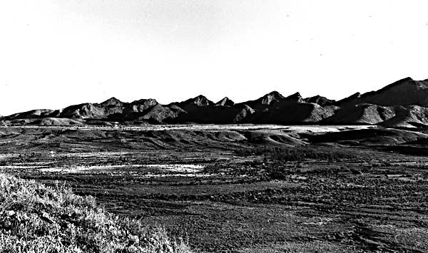
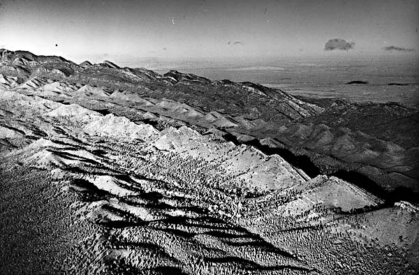
The basin ceased its gentle downwarping in the Late Cambrian and underwent strong deformation during much of the Ordovician (Delamerian orogeny). The deformation produced a fold belt with plunging synclines and anticlines from this thick prism of sedimentary rocks. Most of the exposed rocks from the lower portion of the sequence are mildly metamorphosed. Crystalline basement was mobilized and emplaced as plastic solids in diapiric intrusions or as melts (dating around 470 Ma) at various places (e.g., in the Mt. Lofty Range). On the western flank of the Flinders Range, a pronounced north-trending lineament, the Torrens Crush Zone, separates the western graben from the Flinders Block. Erosion acting on this orogen since the Ordovician(?) has carved out the present landforms. The region has undergone vertical uplift, beginning in the Mesozoic and continuing through the Holocene (Kosciuskan orogeny). Cretaceous sedimentary units lie in grabens and intermontane basins on the west and to the north of the Flinders Range, as well as around Lake Frome. The present-day structurally controlled ridges, monadnocks, and other topographic prominences in the Flinders Range result from differential erosion that leaves quartzites, sandstones, and granites as resistant high hills in the form of linear ridges and curvilinear noses. Escarpments are developed along the Paralana fault east of Mt. Painter and to the west. Around the Flinders Range, traces remain of a low-relief erosion surface predating the later Mesozoic units. Cenozoic erosion has produced thick gravels, derived from older Tertiary silcrete deposits, that are carried across pediments off the flanks of the mountains into outwash deposits (many are calcreted) extending into the basins (Figure T-57.1). Both Lake Frome and Lake Torrens are now ephemeral and saline as the result of high evaporation rates in the semiarid climate. Oblique air photographs (Figure T-57.2 and Figure T-57.3) highlight the topography (flatirons and hogbacks) formed by erosion of the tilted sediments. Major drainage is inherited with river channels superimposed on the structure.
| Figure T-57.3 |
|---|
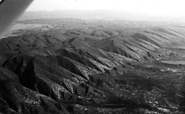 |
Overall, the prominently exposed pattern of metasedimentary units discloses that these rocks were folded and then refolded along different trends. (Axial traces of folds are complexly bent.) Despite this complicated structural history, the rocks are neither tightly folded nor complexly thrusted, which suggests that this area may have been some distance from an actual suture zone. (NMS) References: Brown et al. (1968), Parkin (1969), Twidale (1969). Landsat 22144-23514, December 5, 1980.
Continue to Plate T-58| Chapter 2 table of Contents| Return to Home Page| Complete Table of Contents