 |
 |
|---|---|
| Plate T-58 | Map |
|
|
|---|---|
| Plate T-58 | Map |
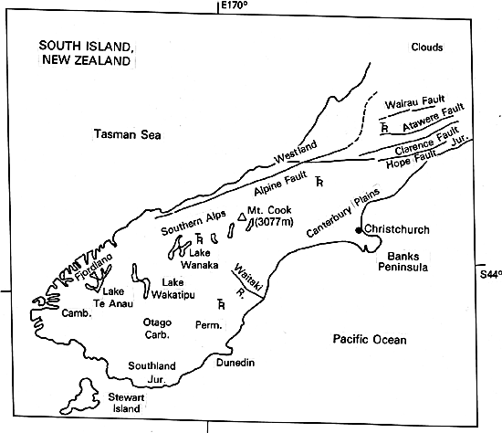
New Zealand has been called a geomorphologist's paradise. This Plate (an HCMM Day Thermal IR image, taken during the southern hemisphere winter) captures both the structure and physiography of South Island. Three features are conspicuous: (1) the Alpine fault, which separates the Southern Alps from the low coastal Westlands; (2) the Alps themselves (rising to 3784 m at Mt. Cook), with their glacially sculptured ridges, moraine dammed lakes, and fjords along the southwest coast; and (3) the Canterbury Plains and Southland, a vast lower area (schists, graywackes, and mudstone) east of the mountains that is still relatively high and hilly in places, but elsewhere is covered by coalesced fans of thick Late Quaternary glacial gravels and outwash carried from the Alps, especially around Christchurch. In land, these deposits show multiple fluvial terracing (Figure T-58.1). Recent marine terraces are developed along the coast; much older elevated terraces are found along the slopes of the Alps. Overall, South Island remains a monument to the influence of tectonic features in determining morphology.
Before about 80 Ma ago, New Zealand was attached to Gondwanaland near Australia. During Paleozoic and Early Mesozoic times, what is now New Zealand was a series of depositional troughs adjacent to Gondwanaland. These troughs accumulated immense thicknesses of shallow and deep-water marine sediment (10000 m in an Early Paleozoic cycle and 30000 m during a Late Paleozoic and Mesozoic cycle). Accretion of island arcs (?) (or continental fragments) along the margin of Gondwanaland first deformed these sediments in the Mid Paleozoic (Silurian/Devonian) and again in the Late Jurassic/Early Cretaceous. During the Cretaceous, the Alpine fault was a suture between the Pacific plate to the east and India/Australia to the west. This fault separates high-pressure/high-temperature Tasman metamorphic rocks on the west from low-temperature/low-pressure Wakatipu rocks on the east.
| Figure T-58.1 | Figure T-58.2 |
|---|---|
 |
 |
Erosion, deposition of marine and nonmarine sediments (including coal, limestone, and chaos breccias), and periodic folding and faulting prevailed between the Late Cretaceous and the close of the Oligocene. A third major deformation, the Kaikoura orogeny, then further folded older units and those of Tertiary age. Climaxing in the Miocene, this tectonic activity persists today. The deformation converted the Alpine fault from a suture line (subduction zone) to a trench/trench transform fault on which motion continues today. Although subduction along South Island has ceased, it continues below the Kermadec Trench east of North Island.
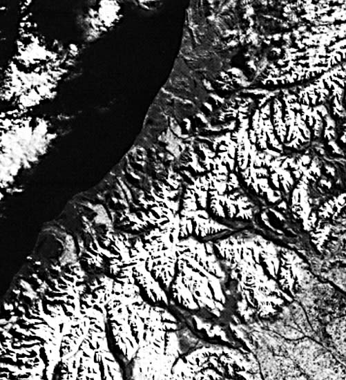
As seen by Landsat (Figure T-58.2), the Alpine fault is defined by abrupt truncation of mountain spurs against the Westland plains. Lithologic correlations indicate dextral strike slip movement estimated to be as great as 800 km, based on somewhat tenuous correlations. The fault splays into four major branch faults -the Wairau, Awatere, Clarence and Hope Faults- in northern South Island (Plate C-11) and is traced as several others cutting across southern North Island. Although it appears to have moved subhorizontally (up to 10 mm/year) over most of its history, the Alpine fault underwent significant vertical movements (with possible thrusting) in the Pliocene/Quaternary interval in which the southern Alps rose to their present heights. The Pacific plate is now being consumed against eastern North Island, and the Australian plate is being subducted south of South Island. The two offset New Zealand Islands are currently drawing apart along the lengthening Alpine transform fault.
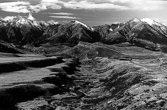
| Figure T-58.3 | Figure T-58.4 |
|---|---|
 |
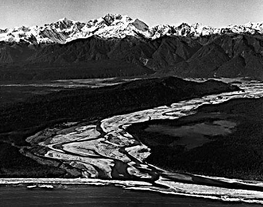 |
Despite its checkered history, the Alpine fault now exhibits many of the characteristics of a well-behaved strike-slip fault, including a spectacularly straight trace and en echelon splays. Figure T-58.3 (looking south across the Wanganui River) follows the trace of the Alpine fault, cutting across ridge spurs with the Southern Alps on the left. Figure T-58.4 (looking east toward the Southern Alps from the sea at the mouth of the Karangama River) shows the exceptional change in relief across the fault. The straight line of faceted spurs marks the trace of the fault. (NMS) References: Grindley (1974), Kingma (1974), Lillie (1980), Suggate (1978). HCMM 0050-03010-2, June 15, 1978.
Continue to Plate T-59| Chapter 2 table of Contents| Return to Home Page| Complete Table of Contents