 |
 |
|---|---|
| Plate T-7 | Map |
|
|
|---|---|
| Plate T-7 | Map |
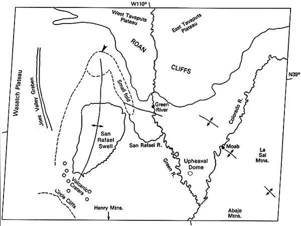
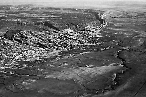
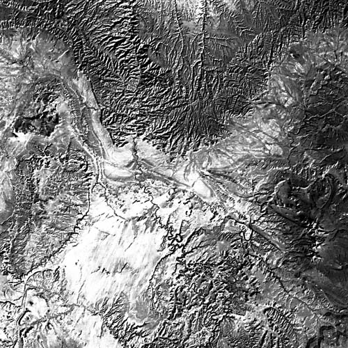
The San Rafael Swell is one of the best-exposed broad anticlinal flexures of Laramide age that dot the Rocky Mountains of the western United States. An arid climate, the degree of erosion, and marked contrasts in resistance to erosion of the sedimentary section combine to produce a spectacular exposure of the interior structure of the archlike swell. Resistant rock units that range from Permian (the highly fractured unit slightly east of center of the swell) to Early Tertiary age (the dark units north of the Roan Cliffs, east of the swell) form a series of roughly elliptical concentric inward-facing hogback ridges and strike valleys that define the fold. Jurassic Navajo sandstone forms the upper part of the bold cliff that defines the culmination of the structure and comprises much of the smooth-stripped structural surface around the northern, western, and southern flanks of the structure. The steeper inward-facing scarp contrasts with the gentle dip slope (Figure T-7.1). The difference in dip of the rocks on east and west is shown by the wider bands of exposure on the more gently dipping west side and the less pronounced scarp face. Beyond the swell, two regional escarpments, the outer Book Cliffs and inner Roan Cliffs, formed by erosion of resistant sedimentary layers extend across the companion Landsat image (Figure T-7.2) along the outer edge of the swell and outline the southern tip of the Tavaputs Plateau. The short, steep scarp face and gentler backslope define a slight dip to the northeast and then north as the Roan escarpment is traced from west to east (Thornbury, 1965; King, 1977).
| Figure T-7.1 | Figure T-7.2 |
|---|---|
 |
 |
A narrow graben (Joe´s Valley graben) lies along the western side of the swell. Careful examination of the northeast flank of the swell reveals a small asymmetric parasitic fold manifested as an elongate (banana-shaped) feature. The dark spots near the south end of the swell mark relatively young volcanic centers. These centers lie generally on trend with the narrow graben mentioned above and may mark the locus of a deeper seated fracture that controls both graben formation and the volcanic activity, each of which postdates the swell.
Close examination of the topography in the core of the swell reveals linear and rectangular patterns, indicating sets of joints that erosion has emphasized by etching. Joints trend northsouth, northwest, west-northwest, and northeast. Several small faults parallel these joints. The joints appear to be related to the processes that produced the fold.
In flowing across the axis of the swell, the San Rafael River disregards both structure and rock type. This suggests that it is either antecedent (developed its course before the formation of the fold) or superimposed (developed its course on an unconformable overlying cover that erosion has subsequently stripped away).
East of the swell in the vicinity of the La Sal Mountains lie the folded and faulted rocks of the Paradox basin. The folds in the Paradox basin are much tighter and are evidently décollement folds. The zone of detachment (décollement ) follows the Pennsylvanian Paradox salt and related evaporite rocks (Rocky Mountain Association of Geologists, 1972).
Figure T-7.3 is a section of a Large Format Camera scene that shows the Black Hills of Wyoming and South Dakota, another well-defined dome lying to the east of the main Rocky Mountains. The tree-covered Precambrian crystalline rocks that core the uplift and the tree-covered resistant ridges of the overlying sedimentary rocks stand out as dark areas in this scene. Ridges formed of more resistant strata and valleys carved in weaker rocks outline the structure around this central core. These completely encircle the dome, giving an annular drainage pattern. A north-trending monocline and/or fault zone is clearly visible as a lineament near the west side of the core area. The dark sedimentary ridges outline several folds in the immediate vicinity of the uplift. The orientation of these folds suggests a component of left-lateral slip along the northwest-trending margin of the uplift. Although the Black Hill uplift is much larger than the San Rafael Swell, the two uplifts are similar in that both are large, rather simple, doubly plunging anticlinal uplifts of Laramide age and both appear to be related to faulting at depth.
| Figure T-7.3 |
|---|
 |
The isolated nature of the broad folds of the Colorado Plateau and Rocky Mountains in general sets them apart from the tight parallel folds normally associated with collision of continental lithospheric plates. It appears that the San Rafael Swell and similar Rocky Mountain uplifts are related to deep-seated thrust or strike-slip faults related to long-sustained (Mesozoic and Early Tertiary) underthrusting along the western margin of North America that took place without collision of continental plates. To the west, this convergence produced folds, thrust-faults, and A-type subduction. East of the western Overthrust Belt, the deformation is manifested as fault-bounded uplifts, many of which are basement-cored (see Plate T-1, western United States). (JRE) Additional References: Gries (1981), Liviccari (1979), Lowell and Gries (1983), Matthews (1978), Suppe (1985). Landsat MSS 1068-17364.
Continue to Plate T-8| Chapter 2 Table of Contents| Return to Home Page| Complete Table of Contents