 |
 |
|---|---|
| Plate T-8 | Map |
|
|
|---|---|
| Plate T-8 | Map |
The late stages of development of the western U.S. Cordillera (Laramide orogeny) produced intermontane structural basins and adjacent mountain blocks in the foreland. Foreland deformation of this style seems to be typical of continental plates adjacent to convergent margins of long duration that have not sustained continent/continent collisions. This tectonic setting produces a pattern of compressive uplifts and basins, with most of the deformation confined to block edges. Twelve kilometers of structural relief between basins and adjacent uplifts is not uncommon. The basins contain several thousand meters of Paleozoic and Mesozoic sedimentary rocks that predate the Laramide orogeny. As much as 5000 m of Cretaceous and Tertiary sediments filled these orogenically defined basins. Deformed Paleocene and Eocene deposits record continuing orogenic activity.
During the Laramide orogeny, basin floors and mountain summits were much closer to sea level than today. After the seas retreated from the Rocky Mountain region, floodplains, swamps, and vast lakes developed in the basins. Drainage systems imposed at that time persist today. Since the Oligocene, episodic epeirogenic uplift gradually raised the entire region, including the Great Plains, to present altitudes. Most of the modern topography is the result of Pliocene/Pleistocene events, including additional uplift, glaciation of the high country, and denudation and dissection of older Tertiary surfaces in the basin by fluvial processes.
In the United States, these distinctive intermontane basins occur principally in the central Rocky Mountains from Colorado and Utah (Uinta basin) to Montana and are best developed in Wyoming, with the Big Horn, Powder River, and Wind River being the largest. Topographically, the basin floors resemble the surface of the western Great Plains, except for vistas of surrounding mountains.
At most boundaries, Paleozoic through Early Tertiary units dip steeply into the basins off uplifted blocks cored by Precambrian rocks. The eroded steeply dipping units form hogbacks and flatirons. Many of the boundaries are thrust or reverse faults. Although other boundaries appear to be monoclinal flexures, faulting is suspected at depth. Most bounding faults show evidence of at least two episodes of Laramide (Late Cretaceous and Eocene) movement, suggesting both thrust and strike-slip types of displacement.
Plate T-8 shows the interior of the Green River basin, one of the largest basin complexes in Wyoming. The mosaic includes nearly all the Green River basin. This basin is bounded on the west by the Wyoming Overthrust Belt (Figure T-6.2), in which folded miogeosynclinal Paleozoic and Mesozoic rocks have been pushed eastward in a series of fault slices that now stand out as parallel mountain ranges. On the south, the basin abuts the east-west-trending Uinta Mountains uplift. To the north and northeast, the Green River basin is hemmed in by the Gros Ventre and Wind River ranges; the latter is a tilt block with a thrust fault on the southwest flank and monoclinal hogbacks on the northeast side. Eastward around the Rock Springs uplift, the basin merges with the Great Divide basin, which, in turn, is bounded by the uparched Sweetwater block and Rawlins uplift and merges with the Washakie basin (synclinal) to the south.
| Figure T-8.1 | Figure T-8.2 |
|---|---|
 |
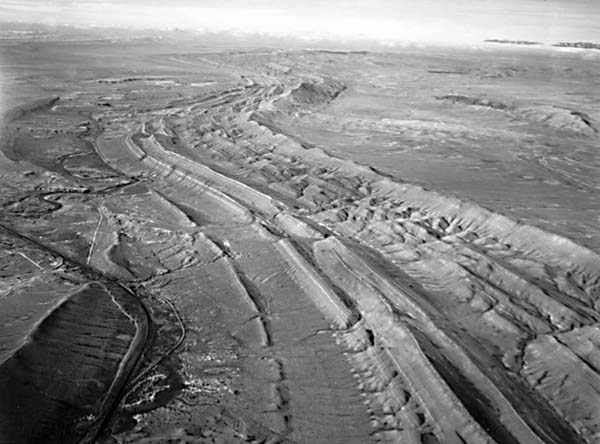 |
Figure T-8.1, a color composite of three ratio bands that enhances differences in lithologic and weathering colors among the surface units (iron-rich surface in orange, vegetation in blue), contains three intraplate structures. The Rock Springs domal uplift is rimmed by inward-facing cuestas carved from Upper Cretaceous (Mesaverde Formation) strata. To its east is the synclinal Washakie basin, with its outward-facing cuestas held up by Lower Tertiary units. North of these structures is the Red Desert (Great Divide) basin, partially encircled by an eastward-facing escarpment. Playas have developed in this basin of interior drainage, along with the Kilpecker dune field, a narrow sand and silt surface that stretches east-west.
Drainage of the Wyoming basins is problematical because the rivers appear to disregard the structure. The Sweetwater River cuts across the Wind River Range and Sweetwater Mountains, the Big Horn River takes a difficult course across the Big Horn Mountains instead of going around them, and the Green River has eroded a deep canyon through the Uintas. Hence, the question of antecedence or superposition once again arises. Subsequent drainage must also be considered. For example, the Green River makes a sharp bend eastward to flow along the strike of uparched beds on the north edge of the Uintas before it cuts southward across the nose in another strike valley. Such drainage anomalies are typical in eroded folded terrane.
Figure T-8.2 highlights differential erosion of tilted beds near Rawlins, Wyoming. This monoclinal structure zig-zags because of changing direction of tilt. Convergent closure of the water gaps indicates the direction of dip. A trellis drainage is well developed on this structure.
| Figure T-8.3 | Figure T-8.4 |
|---|---|
 |
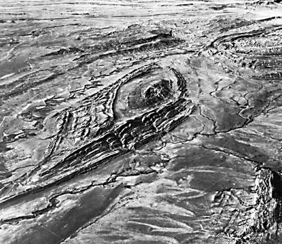 |
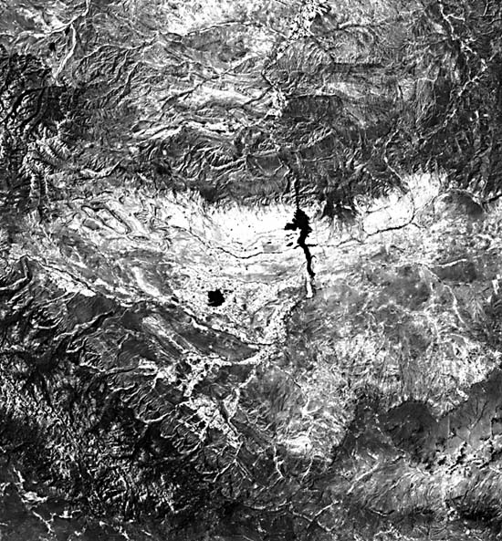
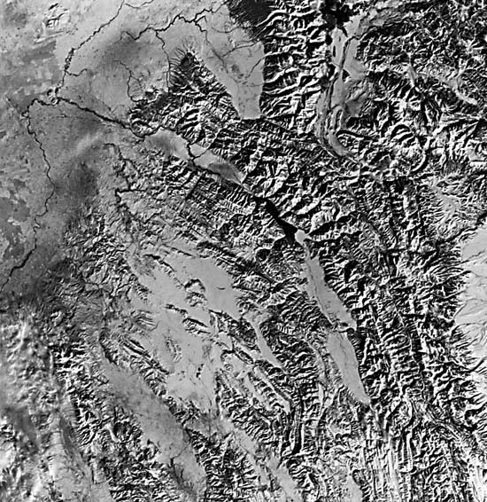
Figure T-8.3 is a Landsat view of the Wind River basin, another large intermontane depression that occupies the center of the state between the Wind River Mountains on the west, the Casper Arch on the east, the Owl Creek/Bridge Mountains on the north, and the Sweetwater Arch to the South. The dip of the flanking ridges around Little Dome in the Wind River basin can be readily determined in Figure T-8.4. The offset linear ridges and valleys on the east side of the dome indicate faulting. The partly annular, partly trellis drainage patterns also reflect a change in structure. Steeper dips of rocks on the east flank are evident. (NMS) References: Armstrong and Oriel (1965), Abrams (1985), Gries (1981, 1983), King (1977), Lowell et al. (1983), Matthews (1978), Suppe (1985), Thornbury (1965). Landsat Mosaic.
Continue to Plate T-9| Chapter 2 Table of Contents| Return to Home Page| Complete Table of Contents