 |
 |
|---|---|
| Plate T-9 | Map |
|
|
|---|---|
| Plate T-9 | Map |
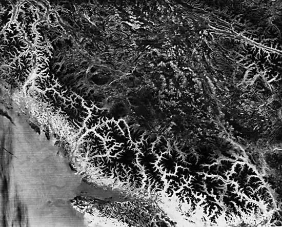
This Plate, a nighttime HCMM thermal image, records a scene that extends 700 km across the southern Canadian Cordillera from the Pacific Ocean almost to the eastern edge of the Rocky Mountains (Wheeler et al., 1972). The tonal patterns, directly tied to sensed temperatures, broadly coincide with different topographic expressions that, in turn, are controlled by structure. These notable variations in topography are surficial evidence of abrupt changes in underlying structures that result from accretion of suspect or exotic terranes to the west side of North America (Jones et al., 1982).
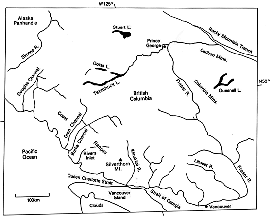
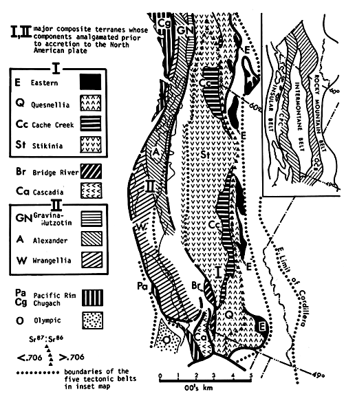
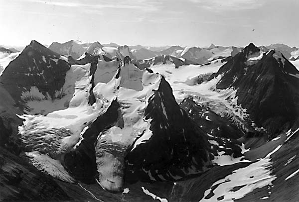
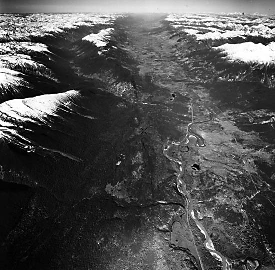
British Columbia has been subdivided into five structural belts (Figure T-9.1 taken from Monger et al., 1982). Westernmost is the seismically active Insular Belt, made up of Upper Cambrian to Neogene volcanic rocks and sedimentary strata, which includes Vancouver Island. The Coast Plutonic complex, which comprises the Coast Ranges, consists principally of Cretaceous and Tertiary granitic rock with some eugeosynclinal sedimentary and volcanic rocks of Late Paleozoic to Tertiary age, probably intermingled with some Early Paleozoic and Precambrian units. These high mountains, with typical rugged alpine crags (Figure T-9.2) resulting from intense glaciation in the Pleistocene, are still snow-covered in late spring (dark (cool) tones in the HCMM image). The strongly glaciated terrane is marked by cirques, arêtes, glacial troughs, and finger lakes (Figure T-9.2). Broad glaciated valleys appear as light (warm) tones; these may be submerged by seawater, approaching their western termini, thus producing fjords that extend well inland beyond the coast (see Plate C-5). The dendritic drainage near the coast changes to structurally controlled patterns and then changes again to more randomly oriented drainage farther inland (Holland, 1964).
| Figure T-9.1 | Figure T-9.2 |
|---|---|
 |
 |
Somewhat lower, more subdued topography is represented in the Intermontane Belt, composed of volcanic and sedimentary rocks emplaced from Late Paleozoic to Late Tertiary time. Granitic intrusions are comagmatic with the volcanic rocks. The belt was deformed at various times from Early Mesozoic to the Neogene. This belt is separated from the Omineca Crystalline Belt to the east by the Fraser and Pinchi faults that mark change in crustal structures. The Omineca Belt consists of highly deformed, metamorphosed miogeosynclinal rocks of Mid-Proterozoic to Mid-Paleozoic ages above Precambrian crystalline basement. The belt is overlain by metamorphosed Paleozoic and Lower Mesozoic volcanogenic and pelitic rocks and Tertiary volcanic rocks. Considerable thrusting has rearranged these units; Jurassic and Cretaceous plutons intrude over wide areas.
The eastern border of the Omineca Crystalline Belt largely coincides with the Rocky Mountain trench. This low, linear valley with high mountains on either side is strikingly expressed in a Landsat-2 image (Figure T-9.3) and an oblique aerial photograph (Figure T-9.4). The western boundary of this graben-like structure is a normal fault (McLeod fault). Its east margin is bounded by the Back Range fault, the first of a series of west-dipping thrusts that characterize the Rocky Mountain Belt. This belt is composed of Devonian to Jurassic miogeosynclinal sedimentary rocks and overlying Upper Jurassic to Paleocene exogeosynclinal Cordillera-derived clastic rocks. Compression toward the northeast displaced belt units up to 200 km onto the craton during the Laramide orogeny. The crust under this belt is relatively thick (45 to 50 km) against the edge of the North American craton, compared with 30 to 35 km thicknesses for belts to the west. In Figure T-9.3, the regions on either side of the trench appear similar topographically, even though quite different structurally and lithologically, due in part to the superposed influence of mountain glaciation that has carved comparable glacial valleys on both terranes.
| Figure T-9.3 | Figure T-9.4 |
|---|---|
 |
 |
Much of British Columbia is constructed from several accreted terranes. Ocean-floor crust was plastered on the craton in places by a series of plate collisions driven by seafloor spreading. Obduction occurred rather than subduction. The crustal blocks, separated by faults, are distinguished by different rocks, geologic histories, and internal structural fabrics. As many as 12 allochthonous terranes are distributed among the five geologic subdivisions of the Canadian Cordillera (Figure T-9.1). More than one suspect terrane maybe present in a belt and can straddle belt boundaries. Five of these terranes occur within the HCMM image: (1) the Cache Creek (Cc) terrane, a Mississippian to Upper Triassic mélange of tectonically disrupted chert, argillite, basalt, alpine-type ultramafics, extensive carbonates, and local blueschist; (2) the Eastern (E) terrane, Upper Paleozoic and Lower Mesozoic (?) basalt, alpine ultramafics, chert, and argillite; (3) the Quesnellia terrane (Q), Upper Paleozoic and Lower Triassic volcanics, volcanoclastics, and carbonates, Upper Triassic and Lower Jurassic volcanics, clastics, and argillites; (4) the Stikinia terrane (St), possibly Upper Precambrian basement, with Mississippian and Permian volcanoclastic rocks, basic to silicic volcanic flows, and carbonate rocks, locally deformed and intruded in Middle to Late Triassic time, overlain by Upper Triassic to Middle Jurassic andesitic volcanic strata; and (5) the Wrangellia terrane (W), an Upper Paleozoic volcanic complex composed of flows, breccias, and volcanoclastic rocks overlain by limestone, clastic rocks, chert, and Upper Triassic pillowed and subaerial basalt flows succeeded by Triassic to Jurassic limestone, cherty limestone, and clastic and volcanic rocks. (NMS) Additional References: Price (1981), Price and Mountjoy (1970), Saleeby (1983). HCMM 0036-10540-3, June 1, 1978.
Continue to Plate T-10| Chapter 2 Table of Contents| Return to Home Page| Complete Table of Contents