 |
 |
|---|---|
| Plate V-14 | Map |
|
|
|---|---|
| Plate V-14 | Map |
The Andes Mountains of South America extend the entire length of the western side of the continent, making up a spectacular continuous (>4100 km) segment of a convergent plate margin along the Pacific Ring of Fire. The geologic setting of this orogenic belt has been described in Plate T-21 (see also Rutland, 1974). This Plate concentrates on the volcanic aspects of this great mountain chain (Casertano, 1963).
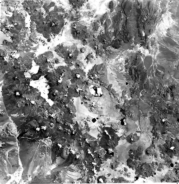
The pictures shown on these two pages lie within the central section of the Andes between latitudes 15 and 30°S, along the borders of Bolivia, Chile, and Argentina. This region hosts the largest number-more than 600-of stratocones (Figure V-14.1) exceeding 5000 m in elevation above sea level anywhere on Earth (Zeil, 1979). These stratocones were emplaced during the Late Tertiary through the Recent. Most are now extinct (indicated by C, for Cerro, before each name), some maybe dormant (indicated by V), and a few remain active, but overall, present activity is low relative to other parts of the Andes. The stratocones are mainly andesitic in composition- the emergent materials are distributed in both lava flows and abundant ignimbrite deposits.
| Figure V-14.1 | Figure V-14.2 |
|---|---|
 |
 |
This part of the Andes, known as the Antofagasta segment, lies south of the northwestward bend of the coast near the Peruvian border. Offshore, the Nazca plate begins subduction (at east-dipping angles from near flat to 30°, from seismic evidence) along the active Peru/Chile Trench (Kulm et al., 1981). Subduction and associated volcanism and seismicity are strongly diminished at the north and south ends of this segment where the Nazca (north) and Juan Fernandez (south) Ridges impinge at high angles onto the South American plate; consumption of these ridges retards the penetration of the Nazca plate under the continent at these gaps, with the intervening segment (Benioff Zone dips >30°) south of this scene now slowed down so that once-extensive volcanism has subdued.
The scene is filled with numerous smaller calc-alkaline volcanoes scattered across the Puna-Altiplano Zone-the section of the High Cordillera within which lie most of the volcanoes in this segment. This zone was once the site of Mesozoic platform sedimentation. It began to experience deformation in the Cretaceous, followed by development of synorogenic to post-orogenic continental basins in the Tertiary. Volcanism proceeded eastward through this area, with culmination in Late Tertiary times. This belt of stratocone volcanism is unusually wide here, exceeding 200 km in places, suggesting a shallower dip for the underlying Benioff Zone. An older belt of volcanism, containing mainly rhyolites and dacites, extends westward from the eastern reach of the Rio Loa and is also present elsewhere (A, B) within the scene.
| Figure V-14.3 | Figure V-14.4 |
|---|---|
 |
 |
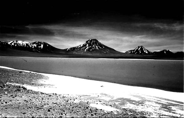
This scene, then, is dominated by the Puna Plateau, with its sedimentary basins largely filled by Tertiary/Quaternary debris, so that most present surfaces lie above 4000 m (Zeil, 1979). Major relief is controlled by the newer volcanic peaks and by partially buried low north-south ranges of folded Paleozoic sedimentary rocks (C). Many basins are landlocked and serve to localize drainage that evaporates into salt-crusted salars and salinas (some containing sodium nitrate). The Rio Lipez is a typical ephemeral stream that empties into the Salar de Uyuni (see Plate KL-13). In general, the shape of the salars in this scene may differ notably from their shapes on published maps. This variability results primarily from periodic infilling following rains in the normally very dry climate. Figure V-14.2 is a near-vertical photo taken in September 1983 with a handheld camera by an astronaut during the 8th Space Transportation System (Shuttle) mission. It shows (arrow) the second highest volcano in the Andes, Ojos de Salado (6880 m), on the Chile/Argentine border (S 27°) and several others. The sharply dissected nature of this volcanic terrain is accentuated by the low Sun angle at that time.
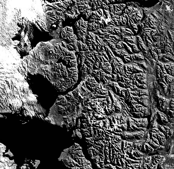
Andean volcanism persists intermittently to the south until it dies out beyond S 45°. Highest elevations in the Andes diminish to less than 4000 m in southern Chile. In the Sur Chico (Little South) region shown from Landsat in Figure V-14.3, the High Cordillera (most peaks less than 2500 m) is a zone of Mesozoic granites and Upper Tertiary/Quaternary volcanics that dies out east of the Longitudinal Valley Zone, a structural depression filled with Quaternary sediments and now occupied by the Golfo Corcovado. The active Volcán Osorno (topmost volcano in Figure V-14.3; closeup view in Figure V-14.4) reaches 2661 m; this, the Volcán Hornopiren (below it), and several others in the scene here fall within a narrow line rather than widely dispersed as are the volcanoes in the Plate. Landsat 2419-13440-7, March 16,1976.
Continue to Plate V-15| | Return to Home Page| Complete Table of Contents