 |
 |
|---|---|
| Plate V-23 | Map |
|
|
|---|---|
| Plate V-23 | Map |
The Deccan Plateau ranks as the world's fourth largest (volumetrically) subcontinental outpouring of plateau basalt lavas extruded at unstable margins during active plate tectonic movements. Once covering more than 1,000,000 km2 with an average thickness of 1 km, its present subaerial volume of 500 000 km3 is 2.5 times larger than the Columbia Plateau basalts, but smaller than flood basalts associated with the Karroo lavas of Africa, the Siberian Plateau in Asia, and the Paraná Plateau of South America (Windley, 1984).
This scene shows a part of the surviving Deccan cover along the west coast of the peninsula section of India. On land, about 500 000 km2 of these flows remain following Cenozoic erosion. Nearly the entire continental portion occurs within a single continuous mass extending eastward from Bombay (just off the image at left center), but outliers have been correlated with these basalts in Madrya Pradesh, Orissa, and the East Coast. A further continuation of the flows is known from drilling and seismic records for the Arabian Sea to the west; one postulate considers this section to have been down-dropped by faulting of part of the Indian block after the lavas were emplaced and probably during the collisional phase following the northward drift of India into Asia.
| Figure V-23.1 | Figure V-23.2 |
|---|---|
 |
 |
Much of the peninsula is a Precambrian shield containing mainly Archean rocks. As such, it was part of the great landmass of Gondwana that began to break up during the Mesozoic. India itself began its northward traverse about 80 Ma ago. The Deccan extrusions commenced in the Late Cretaceous (Cenomanean) and proceeded for 10 to 20 Ma into the Eocene. Eruptions from fissures were relatively quiet and periodic, being classed as Hawaiian type, with associated lower viscosity flows. At least 40 separate flow units can be distinguished, most of them under 30 meters thick but some much greater. Maximum aggregate thicknesses around 2000 m are attained on the western side, as in this Landsat scene. The flows remain nearly horizontal, with a slight eastward inclination. Lithologically, they are continental tholeiites (with labradorite (An 65), enstatite, augite, some olivine, and secondary zeolites; ophitic textures are common). Interbeds of fluvial and estuarine limestones and shales (Lameta beds) and sandstones (Infra-Trappean beds) attest to periods when volcanic activity was quiescent.
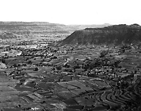
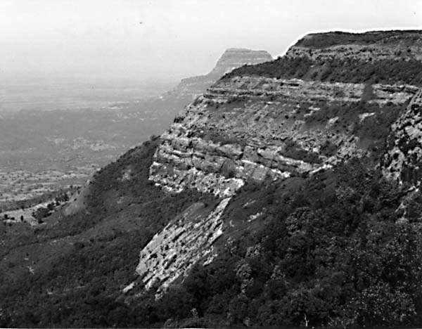
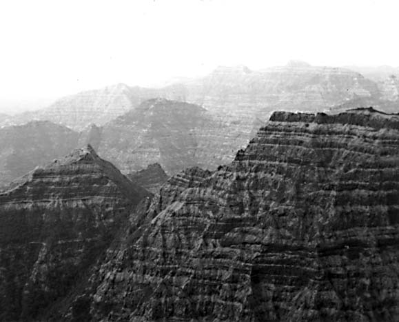
The regional physiography is one of flat-topped hills and ridges and broad valleys (Figure V-23.1) whose surfaces conform to lava layer boundaries. The darker, almost dendritic drainage patterns evident in Figure V-23.1 are characteristic of a plateau topography controlled by horizontal units. In the Plate image, a series of embayed escarpments (Figure V-23.2) are evident near the coastline. This topography is typical of the Western Ghats, a dissected terrain with considerable relief and elevations up to 1000 m (Figure V-23.3). These are "mountains" of denudation rather than of deformation. "Ghats" refers to steps or terraces that are brought about by erosion along different flow units. The term "Deccan trap" denotes a similar concept, with "trap" being a Swedish term for a terraced plateau.
| Figure V-23.3 | Figure V-23.4 |
|---|---|
 |
 |
A remarkable drainage pattern is exhibited in this image and elsewhere along the peninsula, such as that shown in the Landsat scene to the southwest (Figure V-23.4). Rivers such as the Krishna and Bhima, and the Godavari to the north, have their headwaters in the western Ghats within 40 to 100 km of the Arabian Sea. Because of the eastward tilt of the Peninsula, these rivers flow for up to 1000 km to the Bay of Bengal along the east coast rather than across the Ghats divide for short journeys to the west.
Most of the basalt trap rocks are now strongly weathered to regur soils, a deep brown to reddish residue rich in Fe, Mg, Ca, alkalis, and organic matter that is exceptional for growing cotton. Laterites also develop over the region. Vegetation is of the savannah type over most of the plateau. Additional References: Krishnan (1949, 1963), Mehdirata (1962), Narain (1968),Sukheswala and Poldervaart (1958). Landsat 30278-04492-5, December 8, 1978.
Continue to Plate V-24| Chapter 3 Table of Contents.| Return to Home Page| Complete Table of Contents