 |
 |
|---|---|
| Plate V-6 | Map |
|
|
|---|---|
| Plate V-6 | Map |
The west coastal states of the United States typify the landscape of an active boundary region in which the leading edge of a continent-bearing plate overrides or otherwise adjusts to a colliding oceanic plate. North of Cape Mendocino, California, a subduction zone exists below the nearby margin of the boundary between the North American and Pacific plates, and its presence in the Tertiary is evidenced in the structural and petrologic character of the terrain's both at the coast and inland. From the northern Sierra Nevada northward into Canada, Cenozoic volcanism marks the continental edge of the landward side of the North American plate.
The right half of the scene lies at the southwestward end of the High Lava Plains (Plate V-7); the southern boundary of the Columbia Plateau is just north of this image. In the Plains, northwest-trending faults and narrow rift fractures controlled the extrusion of volcanic rocks. Rocks of Lower Tertiary age intermix with younger flow and tephra deposits around Glass Buttes. The Fremont Mountains consist of dissected Pliocene flow units involved in extensive normal faulting. A series of close- spaced normal faults at (A) generated west-facing scarps in a higher plateau made up of Pliocene volcanic rocks between the depressions occupied by Summer and Abert Lakes.
| Figure V-6.1 |
|---|
 |
The left third of the scene extends over much of the Cascade Range-a line of stratocones that occupies a position similar to volcanic edifices rising along modern island arc complexes (Harris, 1976). In the Early Tertiary, a series of andesitic eruptives produced during subduction were interposed within geosynclinal sediments to construct a thick pile of chained volcanic islands. Aggradational growth by continuous eruptions, together with intrusion and uplift, built the platform on which the present Pleistocene volcanoes form the High Cascades belt of lofty peaks that have experienced some stream and glacial erosion but retain much of their original form. Although activity seemingly has diminished, several volcanoes have recorded events within historic times.
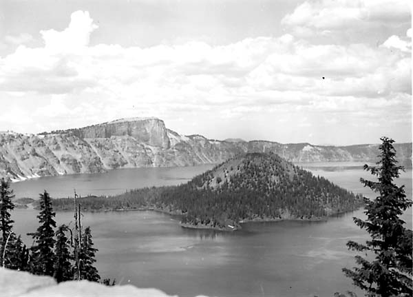
The catastrophic eruption of Mount Mazama about 6500 years ago produced a 9.5-km wide caldera depression now occupied by Crater Lake (Figure V-6.1), almost 610 meters deep, which served as the type area from which Howell Williams (1942) developed his classic concepts on modes of caldera formation. Before its eruption, Mazama reached 3600 meters above sea level and had undergone extensive glaciation. Failure leading to climactic eruptions began as explosive ejection of dacitic pumice, along with invasion of lavas that formed domes and outflows. Later, violent eruptions released nuées ardentes and stratospheric ash clouds that carried tephra northeastward over vast areas. Almost 13 000 km2 were covered by deposits thicker than 15 cm that still affect present surfaces, as at (B). Withdrawal of more than 70 km of wall rock, magma, and pyroclastics deprived the structure of internal support, causing collapse and further ejection of material.
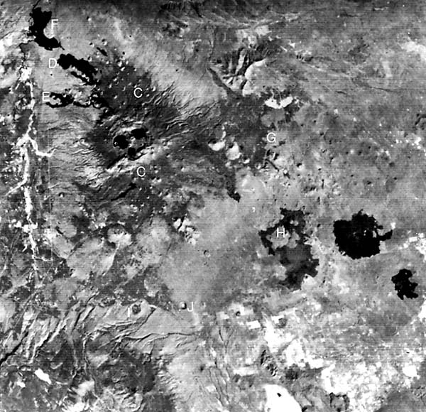
Figure V-6.2 is a Landsat-1 enlargement of the area around the enormous Newberry Volcano, with a 32-km wide base, a shield structure located east of the main Cascade line (Williams, 1935). At its summit is a steep-walled caldera of 8 km maximum length, partially occupied by the Paulina and East Lakes (Figure V-6.3). The oldest rocks (~0.3 Ma) in its floor consist of rhyolites and basalts; basaltic cinder cones and obsidian flows also lie within. Numerous fissure-controlled basaltic cinder cones (C) populate both its north and south flanks. (Note also the light-toned pumiceous deposits along the south caldera rim.) Three prominent basaltic lava fields -Mokst Butte (D), Lava Cascade (E), and Lava Butte (F) -align along a 32-km long northwest-bearing fissure, from which they emerged about 6100 years ago.
| Figure V-6.2 | Figure V-6.3 |
|---|---|
 |
 |
Pleistocene and Holocene lavas extend eastward from Newberry, lapping against hills (kipukas) of older flow units at Pine Mountain (G) and elsewhere (Peterson and Groh, 1965). Even younger Recent pahoehoe flows at the Devil's Garden (H) and to the east retain fresh soil- and vegetation-poor surfaces pockmarked by collapse structures. During pluvial times, parts of these lava plains were filled with shallow lakes. Lavas approaching the surface, on encountering water, set off explosive eruptions that formed maars, as at Hole- in-the-Ground (I). Palagonitic tuff rims survive as eroded ramparts, as at Fort Rock (J). Landsat 1094-18215-7, October 7, 1972.
Continue to Plate V-7| Chapter 3 Table of Contents.| Return to Home Page| Complete Table of Contents