 |
|---|
Victor R. Baker
Rivers flowing to the oceans drain about 68 percent of the Earth's land surface. The remainder of the land either is covered by ice or drains to closed basins. Areas draining to the sea are common in humid regions, whereas those draining to interior closed basins occur in arid regions or in areas of active tectonic subsidence. Some areas of the planet lack surface streams because of extremely low rainfall or because lithologic conditions promote infiltration.
Data on the large rivers of the world are subject to numerous problems of measurement and reliability. The most recent summary (Milliman and Meade, 1983) discusses these problems, but it also reveals some startling facts Table 4-1. Only a score of the world's great rivers are responsible for delivering over half the fresh water and total sediment load to the world's oceans. The Amazon River alone carries about 15 percent of all the water annually discharged by the world's rivers. The annual delivery of suspended sediment to the ocean is about 13.5 x 10.9 metric tons. Over one-tenth of this is delivered by one system, the Ganges-Brahmaputra. Even more remarkable is the second most prolific source of sediment, the Huang He (Yellow River) of China, which yields 1.08 x 10.9 tons per year. The Huang He has one-half the drainage area and one-twentieth the water discharge of the Ganges-Brahmaputra.
Although there are several excellent textbooks in fluvial geomorphology (Gregory and Walling, 1973; Leopold et al., 1964; Richards, 1982), all place an emphasis on small-scale processes. This chapter will introduce the mega-geomorphology of rivers in the hope that it will stimulate a new perspective on the science.
| River | Drainage Area | Length (km) | WATER DISCHARGE | Sediment Discharge | |
|---|---|---|---|---|---|
| (103 km2) | (km) | (m3/s) | (km3/yr) | (103t/yr) | |
| Amazon | 6150 | 6275 | 200000 | 6300 | 900000 |
| Zaire (Congo) | 3820 | 4670 | 40000 | 1250 | 43000 |
| Orinoco | 990 | 2570 | 34880 | 1100 | 210000 |
| Ganges-Brahmaputra | 1480 | 2700 | 30790 | 971 | 1670000 |
| Yangtze | 1940 | 4990 | 28540 | 900 | 478000 |
| Mississippi-Missouri | 3270 | 6260 | 18390 | 580 | 210000 |
| Yenisei | 2580 | 5710 | 17760 | 560 | 13000 |
| Lena | 2500 | 4600 | 16300 | 514 | 12000 |
| Mekong | 790 | 4180 | 14900 | 470 | 160000 |
| Parana-La Plata | 2830 | 3940 | 14900 | 470 | 92000 |
The various regional study areas in this chapter are classified in terms of either their drainage pattern or their channel pattern Table 4-2. The classification is used merely to facilitate discussion, since numerous aspects of the various study areas will be described in the plate descriptions. Especially important are the process parameters (climate, streamflow, and sediment loads) and the evidence of relict features that indicate major past changes in the process parameters.
| Drainage Patterns | Plates |
|---|---|
| Dendritic | Edwards Plateau, Texas (Plate F-) Loes Plateau, China (Plate F-2) Huang He, China (Plate F-3) |
| Centripetal | Elat and AL Jafr (plate F-4) |
| Structurally Controlled | Central
Yemen (Plate F-5) Colorado Plateau, Utah (Plate F-6) Grand Canyon, Arizona (Plate F-7) Rio Caroní, Venezuela (Plate F-8) |
| Pediments | Tucson, Arizona (Plate F-9) |
| Channel Patterns | Plates |
| Meandering | Mississippi River (Plate F-10) |
| Braided | Colville River, Alaska (Plate
F-11) Yukon River, Alaska (Plate F-12) Brahmaputra River (Plate F-13) |
| Anastomosed | Burke and Hamilton
Rivers (Plate F-14) Cooper Creek (Plate F-15) Yangtze River (Plate F-16) |
| Distributary | Fans of
Southeast Iran (Plate F-17) Tian Shan, China Plate F-18) Kosi Fan (Plate F-19) Niger River, Mali (Plate F-20) Pantanal, Brazil (Plate F-21) |
| Transitional | Amazon River
System 1. Manaus (Plate F-22) 2. Solimões River (Plate F-23) 3. Japuré River (Plate F-24) 4. Ucayali River (Plate F-25) |
| Paleochannels | Teays River (Plate F-26) Channeled Scabland (Plate F-27) |
The fluvial dissection of the landscape consists of valleys and their included channelways organized into a system of connection known as a drainage network. Drainage networks display many types of quantitative regularity that are useful in analyzing both the fluvial systems and the terrains that they dissect (Abrahams, 1984). One very useful property is the pattern of dissection (Figure 4-l). Howard (1967) has summarized the geological significance of various drainage patterns (Table 4-3). Dendritic patterns evident in a SIR-A (Shuttle Imaging Radar) image (Figure 4.2) are named for their similarity to branching organic forms. Indeed, the conveyance qualities of such networks make them morphologically similar to blood circulation systems, tree branching, and landscape drainage. Excellent examples of dendritic patterns occur in the absence of structural control, as on the Edwards Plateau of Texas (Plate F-1) and the Loess Plateau of China (Plate F-2). Areas of trellis and rectangular drainage include central Yemen (Plate F-5) and the Colorado Plateau (Plate F-6), respectively. The Al Jafr area of Jordan (Plate F-4) illustrates a centripetal pattern. An example of a drainage pattern not shown in Figure 4-1 but readily recognized at a regional scale in Landsat imagery (Figure 4.3) is the pinnate pattern seen in tributaries to the Dnestr River in the Moldavian S.S.R.
| Pattern | Significance |
|---|---|
| Dendritic | Horizontal sediments or uniformly resistent crystalline rocks; gentle regional slope at present or at time of drainage inception |
| Parallel | Moderate to steep slopes; also in aeas of parallel elongate landforms |
| Trellis | Dipping or folded sedimentary, volcanic, or low-grade metasedimentary rocks; areas of parellel fractures |
| Rectangular | Joints and/or faults at right angles; streams and divides lack regional continuity |
| Radial | Volcanoes, domes, and residual erosion features |
| Annular | Structural domes and basins, diatremes, and possibly stocks |
Drainage networks exist in spatially limited systems known as drainage basins. The drainage network in a basin conveys water and sediment according to the controls of climate, soils, geology, relief, and vegetation. One measure of the network's efficiency is the drainage density, defined as the summation of channel lengths per unit area. The study areas reveal a broad variety of drainage densities.
Drainage may adjust passively to varying resistance of geologic materials, or it may be actively induced to follow a particular course by tectonism. Examples of the latter include faulting, as in the Ganges-Brahmaputra delta region (Plate F-13). Growing folds and domes have affected drainage in the Colorado Plateau (Plate F-6) and central Australia (Plate F-15). Subsidence has been important in the Mississippi (Plate F-10) and Pantanal regions (Plate F-21).
Streams that emerge from mountain fronts onto surrounding plains display a fascinating array of structural and tectonic controls. Where mountain fronts are erosional because of a complex interplay of geomorphic variables, they may develop flanking surfaces of planation called pediments (Plate F-9). Deposition at the mountain front produces alluvial fans because of the tremendous increase in width as a stream emerges from a mountain canyon. Examples include the Tian Shan (Plate F-18), Kosi (Plate F-19), and Pantanal (Plate F-21) areas.
Passive adjustment to structure is a quality of nearly all the study areas. Perhaps the most interesting situations, however, are drainage anomalies, where streams cut across structural zones. Some streams appear to take the most difficult routes possible through fold belts. In his studies of the Appalachians and the Zagros Mountains, Oberlander (1985) has applied the term "obstinate streams" to this phenomenon. The Finke River, described in Chapter 1 (Plate I-4), is an excellent example. The Colorado River (Plates F-6 and F-7) provides other examples.
Rivers display a remarkable variety of channel patterns (Figure 4-4) that are especially amenable to study using spaceborne remote sensing systems. The patterns relate to large-scale conditions of climate and tectonism that can only be appreciated on a global perspective. It is remarkable that, despite the geologic dominance of "big rivers" (Potter, 1978), it is precisely those rivers that have received the least study.
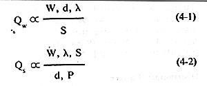
Experimental work by Schumm (1977) has done much to increase our understanding of channel patterns. Pattern adjustments, measured as sinuosity variation, are closely related to the type, size, and amount of sediment load. They are also related to bank resistance and to the discharge characteristics of the stream. Many of the morphological dependencies of river patterns can be summarized in the following expressions:
|
|---|
These relationships are expressed by a large number of empirical equations treating the important independent variables, Qw, a measure of mean annual water discharge, and Qs, a measure of the type of sediment load (ratio of bedload to total load). The dependent variables are the channel width, W, depth, d, the slope of the river channel, S, the sinuosity, P (ratio of channel length to valley length), and the meander wavelength, l (spacing of two successive bends in a meandering river).
| Figure 4.1. Major types of drainage patterns (Howard, 1967). | 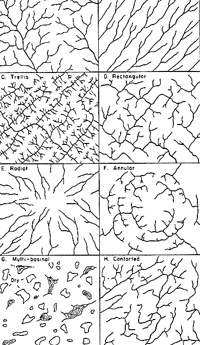 |
|---|
The relationship of channel slope to sinuosity in an experimental river was elaborated by Schumm and Kahn (1972). The data display a clear threshold phenomenon (Figure 4-5), in which steep low-sinuosity streams may change, somewhat abruptly, to somewhat less steep high-sinuosity streams. The former comprise the bedload-type streams that yield braided patterns, whereas the latter yield the familiar meandering patterns associated with streams that transport a high suspended load. The shift between these two stable pattern configurations is illustrated by several study areas, including the Yukon (Plate F-12), Kosi (Plate F-19), Pantanal (Plate F-21), Japurá (Plate F-24), and Ucayali (Plate F-25).
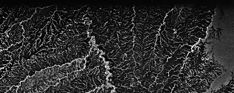 | Figure 4-2.SIR-A radar image of dendritic drainage in east-central Columbia. Most of the image shows an area of dissected plains with a grassland cover that yields low radar return (dark tones). The drainage pattern is strongly enhanced in radar return (bright tones) because the forested stream channels reflect the radar energy back to the receiver. |
|---|
On the basis of the foregoing experimental work, a variety of pattern classifications can be proposed (Schumm, 1981). However, the immense complexity of natural fluvial systems appears to defy our present understanding (Baker, 1978a; Hickin, 1983). For this reason, the classification employed in Table 4-2 must be considered tentative.
Meandering is the most common river pattern, and meandering rivers develop alternating bends with an irregular spacing along the valley trend. Such rivers tend to have relatively narrow, deep channels and stable banks. The system adjusts to varying discharge by vertical accretion on its floodplain and/or by lateral migration of its channel. A vast complex of floodplain depositional features is associated with such rivers, as illustrated by the Mississippi River study area (Plate F-10).
Braided rivers have channels divided into multiple thalwegs by alluvial islands. Braided rivers tend to have steeper gradients, more variable discharge, coarser sediment loads, and lower sinuosity than meandering streams. Their channels tend to be relatively wide and shallow. Braided patterns are ". . . developed depositionally within a channel in which the flow obstructions are sand and gravel deposited by the water moving around them" (Garner, 1974, p. 435). Midchannel bars are emplaced because of local flow incompetence. The resulting braid channels formed by splitting the flow are more competent than the original channel for conveying the load downstream (Leopold et al., 1964). Another way of describing braiding is that it is caused by channel widening that increases the boundary resistance of rivers with noncohesive banks (Church, 1972, p. 74). To maintain enough velocity for sediment transport in a wide, shallow cross section, the channel must divide and form relatively narrow and deep secondary channels through incision. Excellent examples of braiding occur in gravel-transporting rivers, such as Yukon, Colville, and upper Kosi (Plates F-12, F-11, and F-19, respectively). Braiding can also occur in sand-transporting rivers, like the Brahmaputra (Plate F-13). The latter experience more frequent and more complex modification of original bar forms.
| Figure 4-3. Pinnate drainage developed on tributaries to the Dnestr River in parts of Moldavian S.S.R. and Ukrainian S.S.R. Landsat E-2436-08080-7, April 2, 1976. | 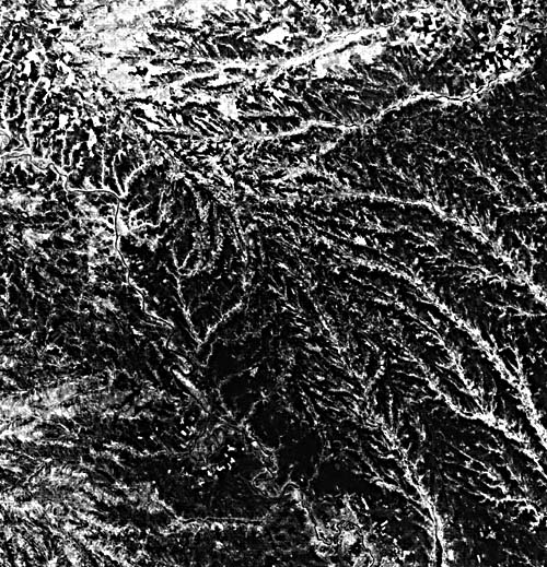 |
|---|
Many multichannel rivers have relatively low gradients, deep and narrow channels, and stable banks. Such river systems have been termed "anastomosed" (Smith and Smith, 1980). The terminology is a bit confused because "anastomosis" is a general designation for interconnected channelways whether in alluvial or in bedrock rivers. Thus, Garner (1974, p. 435), following Bretz (1923), defined an anastomosing channel system as ". . . an erosionally developed network of channels in which the insular flow obstructions represent relict topographic highs and often consist of bedrock." Anastomosis is extensively developed in the Channeled Scabland (Baker, 1978b). Therefore, anastomosing patterns can be considered to be composed of multiple interconnecting channels separated by relatively stable areas of floodplain (in the case of alluvial streams) or bedrock (in the case of bedrock streams). In contrast, braided patterns are single-channel, multiple-thalweg systems with bars of sediment or vegetated islands around which flow is diverted in the channel.
Excellent examples of anastomosed streams occur in the plainslands of east-central Australia (Rust, 1981). The Burke and Hamilton Rivers (Plate F-14) and the Cooper Creek (Plate F-15) study areas illustrate these arid-region varieties. Anastomosis also characterizes very large tropical rivers, such as those in the Amazon Basin (Baker, 1978a). The Solimões and Japurá study areas (Plates F-23 and F-24) illustrate such rivers.
Distributary patterns occur where fluvial systems are spreading water and sediment across depositional basins. Two varieties are fans and deltas. Fans (Bull, 1977) develop in piedmont areas under the influence of both tectonic and climatic controls. Arid-region alluvial fans are constructed by infrequent depositional events that include both debris flows and water flows. Typical arid-region fans occur in the Tucson and Tian Shan study areas (Plates F-9 and F-18). Cold-climate alluvial fans occur in areas of glacial outwash and in periglacial regions. An excellent example is the Sheenjek Fan in the Yukon River study area (Plate F-12).
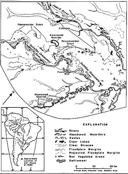 | Figure 4-4.Geomorphic map of the fluvial landscape in northwestern Brazil near Fonte Boa on the Solimões (Amazonas) River. Major tributaries are the Japurá and Juruá Rivers. The map was prepared from an oblique color orbital photograph (AST 21-1682) taken in July 1975, during the Apollo-Soyuz space mission (Holtz et al., 1979). |
|---|
Humid-region alluvial fans are constructed by seasonal or perennial fluvial flows. The Kosi Fan of Nepal and India (Plate F-19) is an example from an area of active mountain building. The Pantanal study area (Plate F-21) illustrates some large fans in the savanna tropics of Brazil.
Deltas are the subject of another chapter in this volume since most deltas involve the interaction of ponded water systems (lakes and oceans) with sediment delivered to a river mouth. However, some basins of deposition in arid regions lack ponded water. Rivers entering these basins may produce typical deltaic morphologies, as in the case of the Niger River study area in Mali, West Africa (Plate F-20).
Five study areas from the Amazon Basin illustrate the complexity of tropical river systems. Many of these complexities arise because the fluvial system is not merely an entity that is totally adjusted to the vagaries of modern conditions. Rivers possess a heritage in which they inherit elements of ancient conditions. Thus, old buried structures, relict alluvium, and progressive development contribute detail to the modern fluvial landscape. The understanding of modern rivers requires an understanding of their past history.
Floodplains are the relatively broad and smooth valley floors constructed by active rivers and periodically covered with floodwater during periods of overbank flow. The floodplain is thus a part of the active erosional and depositional activity of river channels. Floodplains consist of a great variety of depositional materials, including colluvium (debris from valley sides), channel deposits (sand and gravel), and vertical accretion deposits (clay and silt deposited by overbank flows). In addition to fascinating channel patterns, the following study areas illustrate many floodplain features: Mississippi River (Plate F-10), Yukon River (Plate F-12), Brahmaputra River (Plate F-13), Cooper Creek (Plate F-15), Yangtze River (Plate F-16), Manaus (Plate F-22), Solimões (Plate F-23), Japurá (Plate F-24), and Ucayali River (Plate F-25).
| Figure 4-5. Experimental relation between slope and sinousity for an alluvial channel, showing threshold changes between channel pattern types (Schumm and Kahn, 1972). | 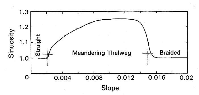 |
|---|
River terraces are abandoned floodplains that formed when their associated rivers flowed at high levels in the past. Many alluvial valleys contain complex flights of river terraces, as in the Huang He region of China (Plate F-3). Such terraces reflect numerous possible controls on river gradients, sedimentation, and erosion, including climatic changes, tectonism (uplift or subsidence), sea level changes, and other controls on base level. Distinguishing among these various causative elements can be a very difficult problem in geomorphology.
A remarkable diversity of ancient river courses can be identified on large-format imagery. Many of the rivers responsible for these paleochannels have experienced immense adjustments of discharge and sediment load, major drainage diversions, and/or episodes of cataclysmic flooding. River adjustments were especially pronounced in the transitions from glacial to interglacial climates (Baker, 1983). The ancient Teays River system (Plate F-26) and the Channeled Scabland (Plate F-27) are two study areas that illustrate these phenomena.
The ability of orbital sensors to detect the regional associations of paleochannels on a global basis should open fascinating opportunities for paleohydrology. Pattern changes between paleochannels and modern channels should be especially interesting. Schumm (1977) has termed such changes "river metamorphosis." The directions and, in some cases, the magnitudes of change can be deduced from various empirical relations and classifications summarized by Schumm.
The study area descriptions that follow will elaborate the details of several river systems. Although this chapter is but a brief introduction to fluvial mega-geomorphology, it is hoped that it will convey the worthwhile perspective on rivers afforded by considering them on large spatial and temporal scales.
Continue to Plate F-1| Chapter 4 Table of Contents.| Return to Home Page| Complete Table of Contents|