 |
 |
|---|---|
| Plate F-1 | Map |
|
|
|---|---|
| Plate F-1 | Map |
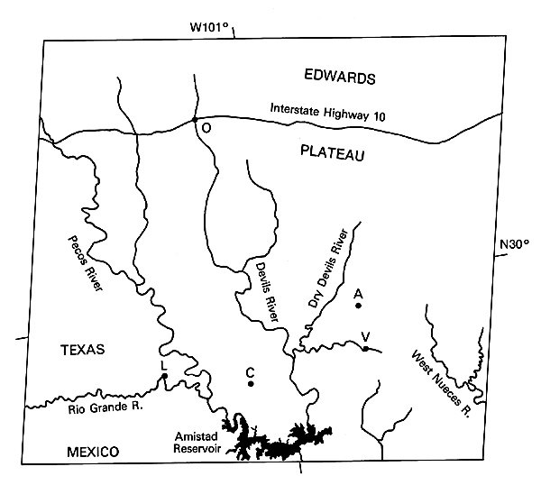
The Edwards Plateau consists of flat-lying Cretaceous carbonate and shale units at elevations of 600 to 900 m, which blanket much of south-central Texas. Amistad Reservoir on the Rio Grande River marks the southern limit of the plateau, where it terminates at the Balcones Escarpment. This escarpment is developed along a zone of Late Cretaceous and Cenozoic monoclinal folds and normal en echelon faults. The zone separates the relatively elevated and resistant Cretaceous limestone units of the plateau from the lower and more erodible Upper Cretaceous and Cenozoic sediments of the Coastal Plain to the south and east.
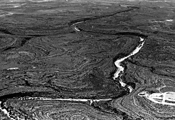
Rivers such as the Pecos and Devils are entrenched 100 to 200 m into the plateau surface (FigureF-1.1). The streams of the plateau include ephemeral varieties such as the Dry Devils River (left in Figure F-1.2) and perennial channels such as the lower Devils River (right in Figure F-1.2), Flow in the latter is maintained by ground-water discharge from the limestone.
The climate and geology of the Edwards Plateau combine to produce dynamic fluvial processes dominated by rare cataclysmic floods. The harsh semiarid conditions result in little human impact on the rocky limestone surface. The few towns include Ozona (O), Comstock (C), and Langtry (L)-famous for Judge Roy Bean's "law west of the Pecos." Annual rainfall averages between 30 and 60 cm, with values increasing along a west-to-east gradient. However, rainfall is extremely variable. Droughts of several years are common, and single storms can locally exceed the annual rainfall. Daily summer temperature maxima typically exceed 37.7°C (100°F) for most of June, July, and August.
| Figure F-1.1 | Figure F-1.2 |
|---|---|
 |
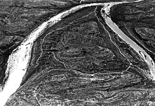 |
The flat-lying rocks of the Edwards Plateau are dissected in overall dendritic patterns. Careful inspection of the scene will reveal local linear trends for some channel segments. These result from joints that developed during gentle warping of the brittle rocks in this region.
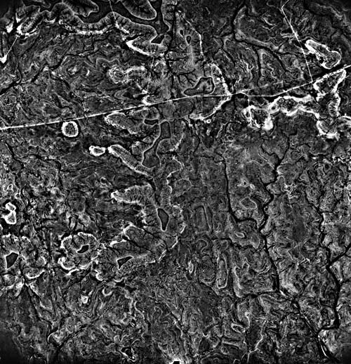
Among the geomorphic factors that enhance runoff concentration from rains in this region are the thin soils, relatively high local relief, steep hillslopes, relatively impermeable bedrock, and high drainage densities. Morphometric studies of drainage networks in this region by R.C. Kochel (1980) showed drainage densities of 4 to 6 km/km2. Drainage density is determined as the summation of channel length in a given area. Similar morphometric studies of plateau areas characterized by lesser flood response in Indiana and the Appalachians determined drainage densities of 2 to 4 km/km2 (Patton and Baker, 1976). Note that the highest drainage densities occur in the Devils and Pecos River regions to the left center of the image. Lower drainage densities occur in the less dissected core of the plateau to the upper right. The high drainage density is readily discerned because the thin layers of carbonate rocks produce an erosional effect that resembles a topographic map (Figure F-1.3).
Central Texas experiences some of the most intense rainstorms and floodflows in the United States. Maximum rainfall is generated by summer thunderstorms and by late summer tropical disturbances that migrate into an otherwise semiarid environment (Baker, 1977). An extreme example of the former is the cloudburst of May 31, 1935, which yielded 56 cm of rainfall in 2 hours 45 minutes near the Balcones Escarpment at D,Hanis, Texas. National record floodflows for small drainage basins have been recorded at Carta Valley (V) and at Loma Alta (A).
| Figure F-1.3 |
|---|
 |
One of the most spectacular floods in the United States struck this region in June 1954, when Hurricane Alice migrated inland from the Gulf of Mexico and centered its precipitation on the Pecos-Devils divide. Rainfall in excess of 1 m was generated over a 2-day period. This produced a flood peak on the lower Pecos River of 27400 m3/s (980000 cfs). The flood stage in the Pecos River Canyon near Langtry (L) exceeded 30 m. In some areas, floodwater actually spilled out of the canyon onto the adjacent plateau surface. The 1954 Pecos Flood was nearly an order of magnitude larger than any flood recorded in the previous 50 years. Paleoflood hydrologic studies of ancient Pecos River floods (Kochel and Baker, 1982) show that the 1954 flood was on the order of a 2000-year event (i.e., it has a 0.0005 probability of occurrence in a given year).
During these rare large floods, the bedrock channels of Edwards Plateau streams are scoured of their bouldery alluvium, exposing fresh white limestone bedrock along channel beds and banks. The high albedo of the valley floors results in the clarity of drainage depiction by this Landsat image (Figures F-1.1 and Figure F-1.2). The gray patina of the plateau limestone on interfluves, plus local soil and vegetation cover, provide a marked contrast to the flood-dominated channel floors when viewed from orbit.Landsat 21711-16314-7, September 29.1979.
Continue to Plate F-2| Chapter 4 Table of Contents.| Return to Home Page| Complete Table of Contents|