 |
 |
|---|---|
| Plate F-12 | Map |
|
|
|---|---|
| Plate F-12 | Map |
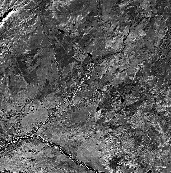
Fort Yukon, located at the junction of the Porcupine and Yukon Rivers, is the only major settlement on this image. The Yukon is the largest river in Alaska, draining an area of 840000 km2 between the Alaska and Brooks Ranges and into the Yukon Territory of western Canada. The river arc in this image is the northernmost point (66°50'N) reached by the river, just across the Arctic Circle.
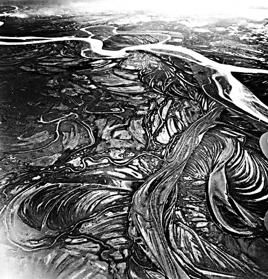
The Yukon channel shows a typical braided pattern as it flows over lowlands of Quaternary alluvium known as the Yukon Flats. In this late summer scene, the river is at high flow, transporting snowmelt from nearby mountain ranges. Approximately 700 km to the west, at its junction with the Koyukuk River, the Yukon no longer has a braided pattern. Instead, meander scrolls and anastomosing side channels dominate the lower Yukon (Figure F-12.1).
The dissected plateau on the eastern side of the image is underlain by Mesozoic sedimentary rocks. The highly sinuous Black River traverses this plain in a relatively narrow valley. Where it emerges on the alluvial plains, the Black River floodplain widens and displays numerous cutoffs and oxbow lakes.
| Figure F-12.1 | Figure F-12.2 |
|---|---|
 |
 |
Farther north, the plain becomes the Porcupine Plateau, underlain by moderately deformed Paleozoic and Mesozoic sedimentary rocks (Wahrhaftig, 1965). The Porcupine River crosses this plateau in a narrow cliff-lined canyon up to 150 m deep, named the "Ramparts." The Porcupine River drains an extensive region of the northern Yukon Territory, immediately east of this image. The river may have imposed itself on the Ramparts because of extensive lakes that developed during the Quaternary in several downwarped basins of the northern Yukon. The ancestral Porcupine may have flowed northeastward to the Beauford Sea.
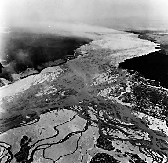
Two large outwash fans, those of the Sheenjek and Christian Rivers, are prominent at the upper left of the image. These rivers deliver sediments from parts of the Porcupine Plateau and Brooks Range to the north. The Yukon itself comprises a fan here, although its extent is not visible on this scene. The braided Yukon presumably deposits considerable load in this reach, since the pattern changes to meandering downstream of the region shown. The occurrence of up to 100 m of Pliocene/Pleistocene lake sediments beneath 45 m of Quaternary alluvium and eolian sand indicates that the Yukon Flats may have been the site of a Late Tertiary lake that occupied a downwarped basin. Silts blown by wind off active braided rivers (Figure F-12.2) were a major source of Pleistocene eolian sedimentation in the region.
| Figure F-12.3 | Figure F-12.4 |
|---|---|
 |
 |
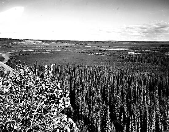
A typical forested floodplain of the Yukon in the Yukon Flats appears in Figure F-12.3. The Yukon Flats display numerous thaw lakes, presumably formed by subsidence as ground ice melted in the permafrost that underlies this region. Beaded drainage also indicates melting of permafrost ground ice, resulting in the transformation of a formerly continuous stream channel into a linear chain of thaw lakes. Other prominent lakes appear to have developed when outwash fans such as the Sheenjek advanced, blocking meltwater flow from adjacent uplands. Such fan-building activity may have been most pronounced at the termination of the last full-glacial period, when extensive sediment was available for transport in the Brooks Range and other highlands. Similarly, the shift to an interglacial climate may also explain the extensive evidence of permafrost disruption.
Figure F-12.4 shows a Landsat scene (1102-20441-7) of approximately the same region, dated November 2, 1972. Many of the lakes that appear dark on the primary scene show up as bright on Figure F-12.4 because they are now frozen. The exceptionally low Sun angle (8°) for this figure helps to emphasize some subtle topographic features that were not evident on the primary scene. Note also the greater extent of bright alluvium in the Yukon River channel. This is the result of decreased flow as water becomes frozen during the winter. Landsat 1408-20430-7, September 4, 1973.
Continue to Plate F-13| Chapter 4 Table of Contents.| Return to Home Page| Complete Table of Contents|