 |
 |
|---|---|
| Plate F-4 | Map |
|
|
|---|---|
| Plate F-4 | Map |
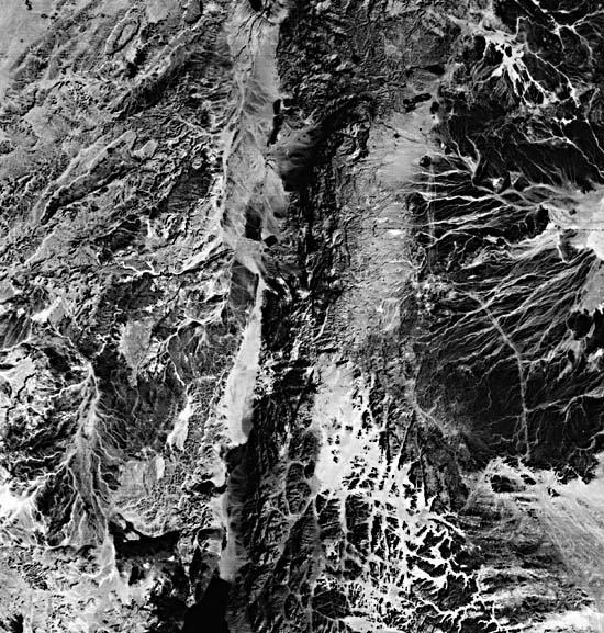
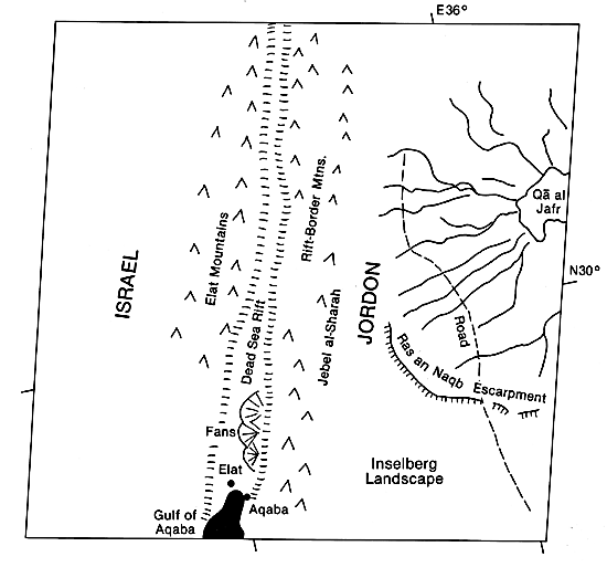
This Landsat scene shows the extreme northern end of the Gulf of Aqaba, which occupies the Dead Sea Rift extending northward across the center of the scene. The rift is a branch of the larger Red Sea spreading axis that separates the Arabian and African Plates. Crustal extension and normal faulting have characterized the rift zone throughout the Neogene. The rift divides two zones of mountains. The Elat Mountains to the west are developed in Precambrian igneous- metamorphic basement rocks overlain by Paleozoic/Mesozoic sandstone ("Nubian" sandstones) and Cretaceous/Tertiary carbonates. To the east, the Precambrian granitic rocks of the Rift/Border Mountains are overlain by thick Paleozoic sandstone units. Northeast of the Ras en Naqb Escarpment, the sandstones are overlain by Lower Cretaceous limestone.
The Dead Sea Rift margins are bounded by extensive talus aprons and alluvial fan bajadas. Israeli geomorphologists have documented the formation of these aprons during wet phases (pluvials) of the Quaternary. The wet phases also involve soil formation, with the production of fines from coarse debris. The fines then serve as matrix for debris flows that develop from rainstorms and abundant sediment. The coarse debris thus passes to mountain-front alluvial fans, which are abundant along the rift valley margin. Because of coarse sediment influxes, these "pluvial" fan surfaces are steep in gradient.
| Figure F-4.1 |
|---|
 |
The present environment is an "interpluvial" arid regime. The modern mean annual precipitation is 30 mm, with a standard deviation of 20 mm. The transition of this extremely arid regime profoundly changed the mountain fronts. Because talus production was slowed, the slopes were eroded, exposing bedrock. This, in turn, promoted rapid runoff from the rare rainstorms. Less sediment was yielded from bare rock, so the streams entrenched the "pluvial" fans and moved fine sediment in narrow valleys to floodplains or playas beyond the alluvial fan bajadas. Repetition of the foregoing processes probably occurred several times during the Quaternary.
The south-central part of the image shows a striking structural control of drainage. Residual sandstone interfluves stand out as dark hills that rise as much as 800 m above the light-toned drainages. The latter are aligned along an intersecting fracture system. As the valleys coalesced by weathering, mass movement, and fluvial removal of debris, they comprised a lower level surface with great sandstone residuals rising above it (Osborn, 1985). Such landscapes are termed "inselberg" landscapes.
| Figure F-4.2 |
|---|
 |
To the northeast of Qa Al Jafr is still another center for internal or landlocked drainage, the Wadi as Sirhãn (Figure F-4.1). A series of linear ephemeral streams, draining from Ard as Sawwan in Jordan, empty into an elongate bajada that lies against low hills cut from volcanic flows just inside northernmost Saudi Arabia.
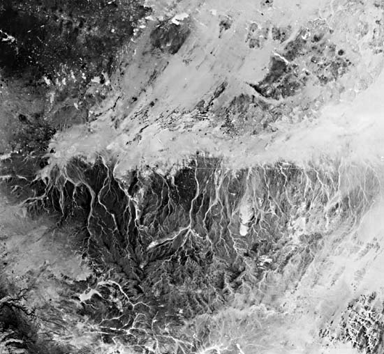
The prominent centripetal drainage system at the right of the Plate is shown more completely in Figure F-4.2, a Return-Beam Vidicon (RBV) scene showing an area of 98 by 98 km. The RBV system on Landsat 3 had a resolution of 30 m per pixel, as compared to 79 m per pixel for the Multispectral Scanner System. The result is a much more detailed rendition of the drainage features surrounding Qa Al Jafr, an immense playa. The overall pattern is centripetal with ephemeral channels incised into old, dark alluvial surfaces that mantle the Cretaceous limestone bedrock. The major highway from Jordan to Saudi Arabia also shows prominently as a linear bright swath across the dark alluvial surfaces. Landsat 30289-07322-6, December 19, 1978.
Continue to Plate F-5| Chapter 4 Table of Contents.| Return to Home Page| Complete Table of Contents|