 |
 |
|---|---|
| Plate D-13 | Map |
|
|
|---|---|
| Plate D-13 | Map |
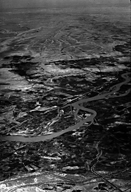
The Shatt el Arab delta has built, up at the northern extremity of the Persian Gulf (Figure D-13.1, an oblique view from Apollo 7). The Shatt el Arab River (A) that feeds it is only 180 km long and is formed by the confluence of the Tigris and Euphrates Rivers (about 2700 km long), which flow through central and eastern Iraq. It is navigable to Al Basrah (B), the chief port of Iraq. Although the Shatt el Arab River owes its origin to these two historically important rivers, the delta is actually formed from the sediments of three rivers. The Karun River (C) rises in west-central Iran and, like the Tigris, drains the Zagros Mountains, which trend northwest-southeast through western Iran. The Karun is probably the primary contributor to the present delta. One meandering branch of the Karun intersects the lower reaches of the Shatt el Arab where the Iranian port of Abadan (D) is located. Each contributor to the delta has extremely erratic discharges, a variability shared by most rivers in arid midlatitude climates. The drainage basin of these three rivers is 792 000 km in area, with an average elevation of 453 m (Samajlov, 1956).
The Tigris/Euphrates Basin, as well as its extension, the Persian Gulf, occupies a zone of subsidence flanked by mountains and/or desert. This elongate depression was formed during an era of mountain building initiated early in the Tertiary that continues with the movement of the Arabian plate against the stable landmass of Asia.
| Figure D-13.1 | Figure D-13.2 |
|---|---|
 |
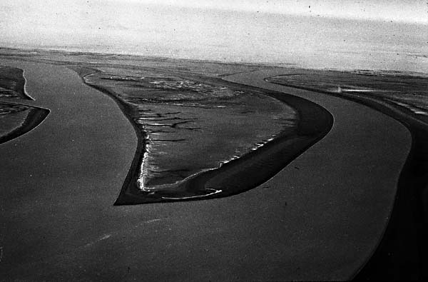 |
The delta exists today in an arid climate, with extremely high rates of evapotranspiration and notable fluctuations in temperature and wind, controlled mainly by topographic variations outside the delta. The Shatt el Arab delta is located at the northern end of an elongate shallow sea where semidiurnal tidal variations reach about 2.5 m. Although much of the delta is made up of broad marshes and associated lowlands (Figure D-13.2) that are valuable as agricultural lands, most coastal regions are tidal flats and sabkhas devoid of extensive vegetation where salts are deposited. Dark gray areas (E) that border the bell-shaped river mouths and tidal channels (Figure D-13.3) correspond to fine-grained sediment deposits that periodically experience tidal inundations. They support a growth of salt-tolerant vegetation (mainly blue-green algal mats). Most marshlands tied to the delta and its river systems lie northwest of the Plate scene. However, freshwater wetlands around the Haur al Hawizeh marsh just northwest of Basrah are visible (F). This area of active subsidence receives a large percentage of the sediments of the Tigris and Euphrates Rivers. The marshlands contain broad expanses of floating cane marsh and bullrush and are inhabited by a unique group of people commonly referred to as the Marsh Arabs.
The amounts and quality of water and sediment delivered to the delta by the Shatt el Arab channel are largely dependent on conditions in the marsh both at and above the confluence of the Tigris and Euphrates Rivers. In the Holocene, these conditions varied between two extremes: the first where only marsh waters and the second where only river waters enter the channel. The rate of upstream subsidence is the process controlling the dominance of one extreme over the other.
| Figure D-13.3 |
|---|
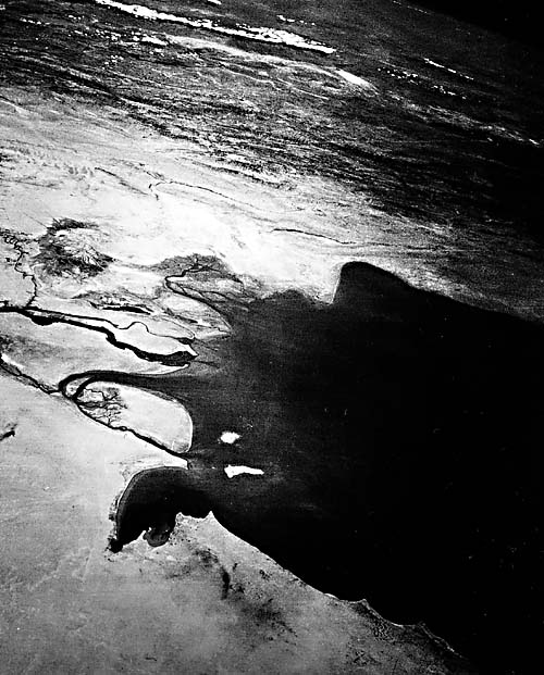 |
In many ways, the Shatt el Arab delta is like the Indus delta on the Pakistan/India coast (Plate D-14). Both deltas are developing under arid climatic controls, the discharges are of the same order of magnitude, tidal ranges are the same (between 2 and 3 m), and except for small stands of mangrove trees, their deltaic plains are largely devoid of vegetation. One sharp difference is the extremely low wave energy attacking the Shatt el Arab delta. Due to low wave energy, only narrow beaches (G) and small dune systems lie along the leading edge of the delta. Mudflats and sandbars dissected by tidal channels (H) dominate the prograding delta front. Where seawater is trapped during very high (storm) tides, salt pans (I) develop. White areas in the scene are barren regions of salt deposition along with gypsum/anhydrite. Cultivated areas (J) in the lower delta generally follow the Shatt el Arab and Karun channels. Offshore, elongate turbidity patterns (K) and island shapes (L) associated with the flaring channel mouths indicate that subaqueous as well as subaerial parts of the lower delta are being molded by strong bidirectional tidal currents, the primary transport agents.
Man has profoundly affected the Shatt el Arab and its delta. The network of irrigation ditches in the delta region appears to be responsible for a nearly 64 percent water loss after contributing sources reach the main channel. Most loss is accounted for by evapotranspiration in the irrigated fields (M) of the lower basin and the Hawizeh marsh. In the desert west of the delta, man's activity in producing hydrocarbons is evidenced by the long black lines trending roughly northwest-southeast, which represent smoke plumes from gas flares at oil facilities around the rich fields in Iraq and Kuwait. Landsat 2653-06291, December 30, 1980.
Continue to Plate D-14| Chapter 5 Table of Contents| Return to Home Page| Complete Table of Contents|