 |
 |
|---|---|
| Plate D-14 | Map |
|
|
|---|---|
| Plate D-14 | Map |
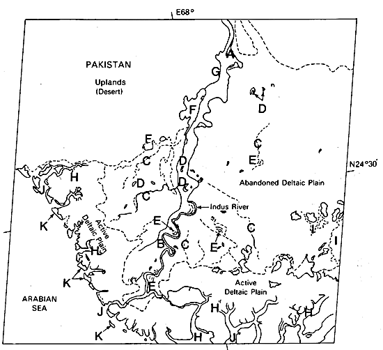
The 2900-km long Indus River rises in the Himalaya Mountains of western Tibet at an elevation of about 5183 m. It follows a precipitous course west through Tibet and then northwest across Kashmir. In western Kashmir, it flows down a narrow passage nearly 396 m deep in places through the mountains until it enters Pakistan and proceeds almost due south to the point where it is joined by the Panjnab River. Shifting to the southwest, the Indus follows a contorted path before emptying into the Arabian Sea and creating a complicated protuberance of terrigenous clastic sediments known as the Indus delta.
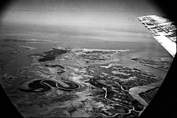
In its upper valley, the Indus flows primarily as a braided stream because of a high gradient associated with the river course and an erratic pattern of discharge. The southern limit of braiding in the Indus can be seen in the river patterns and associated alluvial morphology in the top-central part of the scene (A). As the river approaches the Arabian Sea, it becomes a meandering system in its lower reaches (B). In historic times, the Indus River has switched its location, thus contributing to the construction of a broad deltaic plain, the largest part of which does not receive active sedimentation from the modern river (Wells and Coleman, 1984). Within the abandoned deltaic plain (right-central part of the scene), many remnants of once-active distributaries (C) and their associated alluvial features are still apparent. Oxbow lakes, meander loops, and abandoned channels (D) (Figure D-14.1), plus ridge- swale scrollwork (E) associated with the deposition of coarse point-bar sediments, are formed during the lateral migration of the river. These products of a meandering river system are also very much a part of the alluvial morphology being created by the modern active Indus River (Holmes, 1968).
| Figure D-14.1 | Figure D-14.2 |
|---|---|
 |
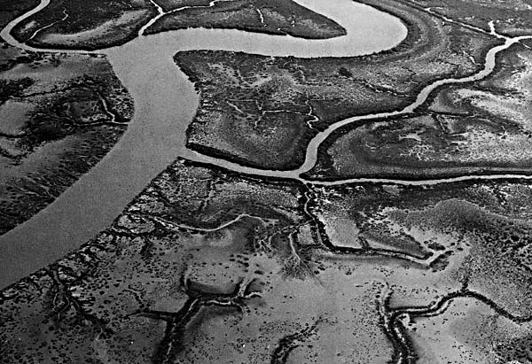 |
The delta has formed in an arid climate under conditions of high river discharge (~400 million metric tons of sediment per year), a moderate tide range (2.6 m), extremely high wave energy (14 x 107 ergs/sec/m), and strong monsoonal winds from the southwest in the summer and from the northeast in the winter. The resultant rather coarse- grained delta, which has acquired a lobate shape, is lacking in luxuriant vegetation and is dissected by numerous mangrove- lined tidal channels (C) (Figure D-14.2) in the lower deltaic plain. Estimates of delta building over the last 5000 years indicate an average progradation rate of approximately 30 m/year. Morphology of the Indus lies midway between that of a fluvially dominated delta, with distributaries that protrude into the basin of deposition, and a wave-dominated system, with little expression along the coast, except where characterized by beach and dune deposits.
Plate D-14 clearly shows the distinction between the Indus delta's abandoned and active deltaic plains, as well as the desert uplands (upper left sector of the scene) that form the delta's western boundary. Once the river ceases to deliver sediments as a product of natural diversions or of man's intervention by building artificial levees and other structures, this area of the delta will become an abandoned deltaic plain. In recent years, a high proportion of water from the Indus has been diverted for irrigation, thus considerably reducing the effective discharge. Water storage areas (F) and manmade canals (G) for diverting Indus River water are apparent along the west margin of the delta.
The lower or active deltaic plain is roughly delineated by the landward boundary of salt-water intrusion, the position of which is easily seen on Plate D-14. This lower deltaic plain is crossed by a complicated network of meandering tidal channels (H) that daily inundate the region with salt water and fine- grained suspended sediment. Figure D-14.2 shows that the margins of these tidal channels are commonly lined by salt- tolerant mangrove vegetation on a sand to silt substrate, while barren flats are common in the interchannel areas. Along the creek margins, small crevasses/splays build sediment wedges into interchannel regions. These features are generally too small to be clearly delineated on the Plate image. Even though the tide range of the Indus is not extreme (~2 to 3 m), when combined with the effects of the storm tides of the southwest monsoon in summer, vast areas of both the active and lower abandoned deltaic plain are inundated with salt water. As a result of this yearly cycle, combined with an arid climate, low-relief areas trap salt water that evaporates to create rather extensive salt flats (I). The bell-shaped channels (J) associated with river mouths and tidal creeks are other indicators of tidal influence on this delta's morphology.
| Figure D-14.3 |
|---|
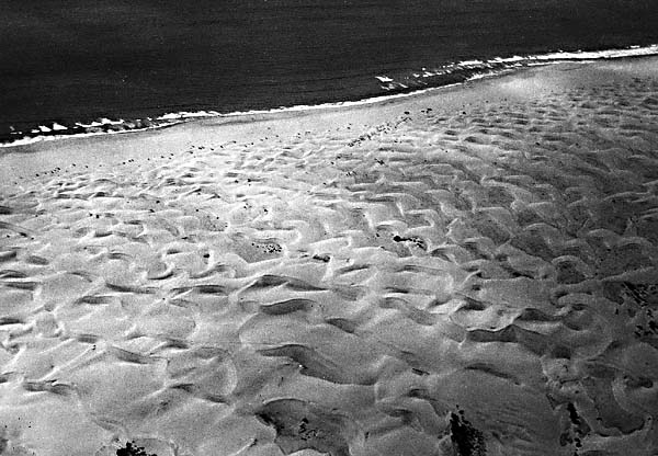 |
Waves are the single most important process variable in shaping the Indus delta. Intense monsoonal winds arriving from the southwest (May-September) are responsible for an abnormally high level of wave energy at the coast. The effect of this wave energy has been to concentrate the coarse sediments at the shoreline, produce strong longshore currents, and generally straighten the configuration of the coastline. The result has been the development of beach, barrier, and dune complexes (K) at the leading edge of the subaerial delta. Figure D-14.3 illustrates the redistribution of sandy sediments that were originally concentrated at the shoreline by wave activity and then transported into dunes by eolian processes. These dunes reach heights of several meters and are in a state of active migration. They occur along the seaward and western margin of the Indus delta.
Because of man's intervention in the natural delta- building processes of the Indus, this delta's future is uncertain. Extensive use of fresh water for irrigation during the 20th century has decreased the Indus River discharge approximately fourfold. If this trend continues, we can expect the delta to evolve into a more wave-dominated form characterized by extensive beach, beach ridges, and dune formation, probably accompanied by substantial coastal retreat. Landsat 1228-05274-7, March 8, 1973.
Continue to Plate D-15| Chapter 5 Table of Contents| Return to Home Page| Complete Table of Contents|