 |
 |
|---|---|
| Plate D-2 | Map |
|
|
|---|---|
| Plate D-2 | Map |
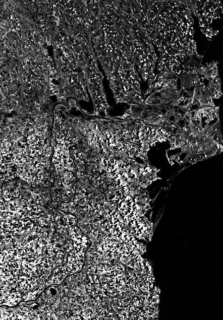
The Danube River was known to the Greeks as the Ister River, and Herodotus called it "the greatest of rivers" Napoleon referred to it as the "king of rivers." The Danube is the second largest river in Europe; it is approximately 2900 km long and drains an area slightly larger than 817 000 km2. It rises in the Black Forest Mountains of Germany and empties into the Black Sea. At the Romanian border, the river once cut a channel through the mountain ridge that joins the Carpathian arc with the Balkan Mountains, and a large interior sea was formed. Not until Recent geologic times has the Danube lowered its channel through the gap to drain this interior sea. The delta area (4345 km2) of the Danube was created in these times. Mean annual discharge is 6500 m3/sec, and maximum discharge up to 10 times that amount has been documented. Sediment discharge averages 122 million tons/year, of which 54 million tons consist of bed load (Samajlov, 1956).
To the north and west of the river delta, primarily Pliocene and Miocene sedimentary rocks form north-south-trending low hills (A) capped by Pleistocene loess up to 200 m high. East of the river and south of the delta, Paleozoic and Mesozoic sediments form high rolling hills (B) that attain elevations of 450 m. The present density of farmlands, however, effectively masks the relief in the Landsat Plate mosaic.
The main channel of the Danube (C) is highly migratory within its alluvial valley, so that numerous meander scars (D) are present within the valley. Small stretches of river braiding are found along the valley course. As the Danube turns abruptly east to form its delta plain, sedimentation has blocked numerous valleys of the north- south-trending topography, forming elongated freshwater lakes (E). Lakes found in the Mackenzie River delta of Canada are formed in the same manner (Figure D-2.l). The major distributaries of the Danube (F) consist of three major channels, the St. George to the south, the Sulina in the middle, and the Kilia to the north (Almazov et al., 1963). The St. George arm is 120 km long and has widths ranging from 200 to 500 m, while the Sulina arm, prior to 1860, had a length of 100 km and a width of 250 m. The Sulina was artificially diked in the period 1860-1895 for navigation purposes. Kilia, the youngest of the distributaries, having formed within the past 600 years, now receives the major part of the flow. It is slightly longer than 100 km and ranges in width from 300 to 700 m. The distributary channels are bordered by well-developed natural levees that are quite narrow, generally less than 250 m wide. Downstream, the natural levees decrease in width and height. Sinuous distributary channels result from migration as the channel cuts through former beach-ridge trends. Like distributaries in many deltas, migration of the channel is controlled by the presence of coarser material. The Kilia distributary to the north is the youngest part of the delta. Numerous bifurcated channels and overbank splays (G) are present, most of which are too small to show up in the satellite image. Offshore of these young prograding distributaries, slope is extremely low, the coastline is very muddy, and beaches are entirely absent.
| Figure D-2.1 | Figure D-2.2 |
|---|---|
 |
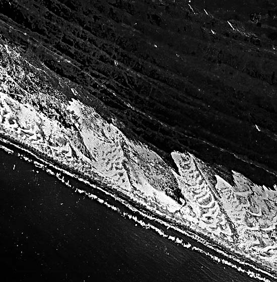 |
Several abandoned distributary channels (H) are present within the delta plain. They indicate that the channels shift with time in response to subtle changes in slope, supplying sediment to all parts of the delta. In general, the delta consists of an older upstream part and a younger downstream part. Separating the two units is a large beach-ridge complex (I). These beach ridges display both progradational and transgressive characteristics. They are obviously associated with the prograding river mouths of the St. George, Sulina, and older distributaries. Once the Kilia distributary became the dominant channel, wave reworking of the older distributaries resulted in the formation of transgressive beaches at these river mouths. Similar transgressive beach deposits are shown in Figure D-2.2 from the São Francisco River, Brazil. The Danube beach ridges have heights of 5 to 10 m, and many contain coastal eolian dunes.
Predominant in the delta plain are roseau cane (marsh cane, Phragmites) marshes (J) and freshwater lakes (K). The marshes are an important resource of the delta, providing a major nesting place for waterfowl. The roseau cane forms thick root mats and results in organic content being exceptionally high in the delta deposits. Much of the delta area is occupied by freshwater lakes up to 3 to 4 m deep. These lakes are initially filled by overbank flow of organic-rich clays. As filling with organic-rich clays proceeds, the lakes become isolated from the overbank splays, and thick floating organic mats form the final fill.
Alongshore drift north and south of the delta has built linear barrier islands and spits (M), which enclose broad brackish and marine estuaries and lagoons (L). The barrier islands have relatively steep shorefaces, and many are characterized by coastal eolian dunes. The estuaries are important biological environments in that they form the spawning ground for many economically valuable marine species. Landsat Mosaic, 2904-07510-7 and 2904-07504 -7.
Continue to Plate D-3| Chapter 5 Table of Contents| Return to Home Page| Complete Table of Contents