 |
 |
|---|---|
| Plate D-3 | Map |
|
|
|---|---|
| Plate D-3 | Map |
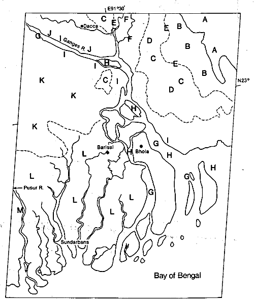
The Ganges and Brahmaputra Rivers combined have formed one of the largest deltas in the world, comprising approximately 105 640 km2. The Bengal Basin, into which this delta has prograded, is bordered on the west and northwest by Lower Jurassic volcanics and on the east by Eocene sandstones and limestones. The southern boundary is the Bay of Bengal. The Ganges River originates near the Tibet/India border, and then flows southeast across India to combine with the Brahmaputra in the country of Bangladesh. The Brahmaputra River has its source in Tibet along the northern slope of the Himalayas, and flows across Assam into Bangladesh. The drainage basin, approximately 1.6 million km2 in area, is geologically young, with large volumes of unconsolidated sediment available for transport (Morgan and McIntire, 1957, 1959).
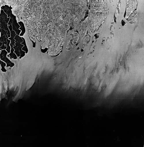
The Ganges is primarily a meandering river, while the Brahmaputra is primarily a braided channel (Plate F-13). Their combined discharge into the Bay of Bengal is approximately 82 000 m3/sec during flood. Sediment load is extremely high, with suspended sediment load during flood stage reaching as high as 13 million tons per day (Coleman, 1969). Figure D-3.1 is a band 5 version of the lower Landsat image in the Plate mosaic that highlights the vast sediment load beyond the mouths of the Ganges. Because the climate within the delta is monsoonal, rainfall is seasonal. Vegetation is highly varied and generally dense in areas that have not been reclaimed for agriculture. The Bengal coast is mesotidal, with an average tidal range of 2 m. Wave energy modifying the coast is relatively low because of the extremely low offshore gradients that front the active delta.
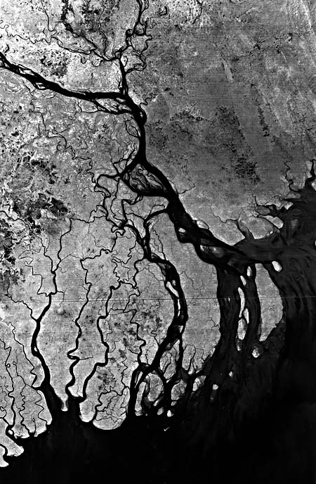
The mosaic covers the eastern active deltaic part of the Ganges/Brahmaputra Rivers and illustrates those landforms that are characteristic of a rapidly migrating channel system partially modified by tidal processes. The Tripura Hills (A) that bound the delta to the east consist of highly weathered Tertiary sediments that show abundant dissection resulting from the high annual runoff. These hills are a southerly extension of the folds seen in Plate T-48 with topography that is highly irregular and relief ranging from a few tens of meters to several hundred meters. Emanating from these highlands are a series of heavily vegetated alluvial fans (B) and small river terraces. During the Pleistocene, large volumes of sediment were delivered to the Bengal Basin, and former Pleistocene terrace surfaces are common along the valley of the river systems. The Tippera surface (C) has been assigned a Late Pleistocene age and consists of an extremely flat terrace composed of highly oxidized and deeply weathered clays and silts. The surface is easily mapped on aerial photographs because it displays a distinctive rectangular drainage pattern (D) resulting from man's modification for agriculture practices. The surface has an elevation of several meters above the Recent fluvial and deltaic floodplain. During the Pleistocene and even in Holocene times, faulting (E) has been active in this earthquake-prone area, and many of the boundaries of Pleistocene surfaces are marked by relatively straight fault- controlled boundaries. Smaller rivers, such as the Meghna (F), have cut into these Pleistocene surfaces, forming rather extensive meander belts of abandoned channel scars.
| Figure D-3.1 | Figure D-3.2 |
|---|---|
 |
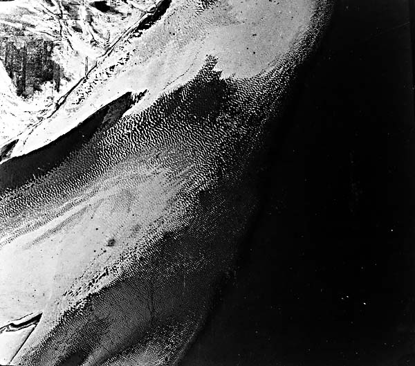 |
The major part of the image shows the Recent delta surface of the Ganges/Brahmaputra Rivers. The main river channel displays a braided and anastomosing channel pattern (G). Figure D-3.2 illustrates this type of channel morphology, showing part of a midchannel island with large bed forms in an active distributary of the Brahmaputra River. Note the large number of active channels and the innumerable midchannel islands or sand bars (chars) that are characteristic of this type of channel pattern (H). These sand bars separate the flow into several channels, resulting in the braided pattern of the river. In such rivers, the sediment bedload is abnormally high, and rapid aggravation in the channel is common, constantly forcing the channel to migrate laterally. Recent channel scars (I), often unvegetated, can be observed along the margins of the active channels. During flood stage, these sand bars are generally eroded on their upstream end, with deposition on the downstream end, causing significant downstream migration of the islands from year to year.
The range of river stage varies considerably from low to flood stage, and adjacent channel banks are often characterized by many overbank splays (J). These splays are responsible for building up rather thick and broad natural levees that border the active channels.
In the northwest part of the image, the morphology of the delta plain is dominated by the abandoned channel scars of former river courses (K). These abandoned courses display evidence of both migratory braided and meander channel scars. These surfaces form the bulk of the rice-and jute- farming areas of Bangladesh. In the southeastern part of the image, the delta surface elevation becomes low enough to be inundated by tidal waters, and much of this area displays tidal plain morphology. A large percentage of the region has been diked (L), and the land has been reclaimed for agricultural purposes. The undiked regions (M), in the southwesternmost part of the image, are dominated by mangrove vegetation. Large tidal channels and tidal drainage networks characterize this part of the delta plain. Landsat Mosaic 30303-03450-7 and 30303-03452-7.
Continue to Plate D-4| Chapter 5 Table of Contents| Return to Home Page| Complete Table of Contents|