 |
 |
|---|---|
| Plate D-4 | Map |
|
|
|---|---|
| Plate D-4 | Map |
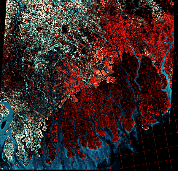
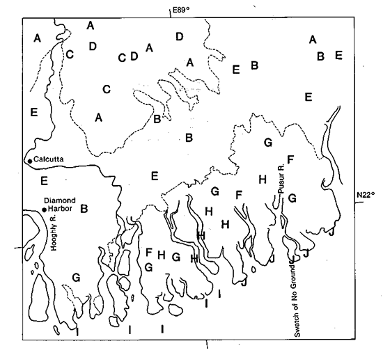
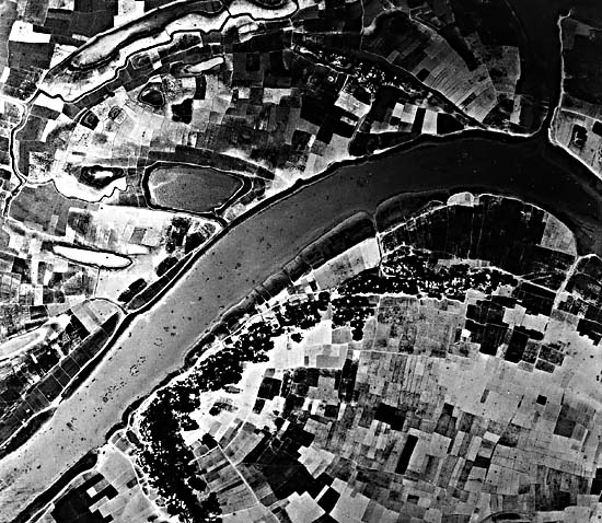
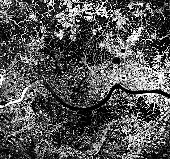
This color image covers the western abandoned and tidally dominated part of the Ganges/Brahmaputra River delta. Throughout Pleistocene times, the site of active deltaic sedimentation has switched. Today, the Ganges merges with the Brahmaputra, and the site of active sedimentation lies to the east (illustrated on Plate D-4). The major area of abandoned deltaic plain lies in the northwestern part of the image. More of this abandoned delta to the north appears in Figure D-4.1. Numerous abandoned channel scars (A) dominate the surface morphology. These scars are apparently remnants of former courses of the Ganges River and many of its distributaries. Most of the scars indicate that a meandering channel (Figure D-4.2) was dominant, now extensively modified by man. Channel scars are of similar size to channels presently active along the Ganges and its distributaries. Many of these former riverine channels are now tidally dominated (B). The Hooghly and Pusar Rivers are good examples of former major courses of the Ganges that have now become tidally dominated. Some well-defined meander belts display excellent examples of "ridge and swale" topography (C). Oxbow lakes (D), remnant meander channels that have been isolated by river cutoffs, are common on the abandoned delta surface. Much of the original channel morphology has been modified by man for agricultural purposes (Figure D-4.2), and in some cases, the modifications have nearly obliterated the original river-plain morphology.
| Figure D-4.1 | Figure D-4.2 |
|---|---|
 |
 |
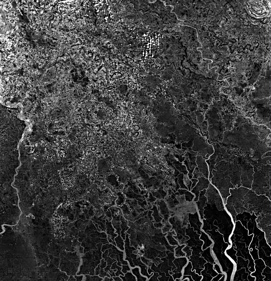
The inland part of the tidal plain has been diked, and the former saline lands have been converted to various agricultural and marine farming practices. This reclaimed land (E) has retained some of the general morphology of the original deltaic channel scars, but it has been modified by tidal drainage networks. Originally, this surface formed an extreme expanse of mangrove forests referred to as the Sunderbans. The only remaining large expanse of tidally dominated mangrove forests is shown on the image by the dark-red color (E), and here dense stands of many species of mangrove exist. The mangrove swamp is dissected by an intricate network of tidal drainage channels (G). Figure D-4.3 illustrates an intricate, dendritic, tidal drainage pattern on an abandoned delta surface of the Ganges/Brahmaputra delta. The channels display a variety of morphologies, ranging from highly sinuous patterns to straight, rectangular networks.
The larger tidal channels (H) form bell-shaped estuaries that are quite deep, and many of them serve as major transport arteries. Inland, the estuarine channels display highly sinuous channel patterns, but appear to be stable rather than migratory. Comparison of old maps and aerial photographs with present- day imagery indicates that some major channel patterns have not changed in tens of years. Figure D-4.3 illustrates some of the delicate and efficient drainage networks that have been established on this former delta surface, nearly obliterating the original delta morphology.
| Figure D-4.3 |
|---|
 |
Typical of many high tidal estuaries is the bell- or funnel-shaped river mouth. The tidal range varies considerably along this coast-mean tidal range is 1.7 m (spring, 2.3 m) at the mouth of the Pusar River, and 2.0 m (spring, 2.7 m) at the mouth of the Hooghly River. Tidal range increases inland as the tidal discharge moves into a much smaller cross section associated with decreasing channel widths. Inland from the mouth of the Hooghly River, the mean tidal range increases to 3.7 m (spring, 4.9 m).
The coastline is extremely irregular as a result of the large number of tidal channels that dissect the coast. Broad mud and silt flats border the coast (I). On the image (acquired at high tide), these mudflats are shown as highly turbid plumes. At low tide, many of these flats are exposed as fluid mudbanks. Most of the banks display elongated patterns, aligned in an onshore- offshore direction. This type of subaqueous morphology is common along many high tidal estuaries, and these shoals have been called "tidal ridges." The Bay of Bengal has relatively low offshore wave energy, and this, combined with the generally low offshore gradients, results in a low-wave- energy coastline. Much of the coast is blanketed by the mudflats, and only at isolated regions is any expanse of beach ridges found. The beach deposits (J) are most commonly composed of reworked shell debris and fine sand. These types of beach ridges have been referred to as cheniers on other delta coasts. Note that they are most commonly developed in the southeastern part of the image, opposite the Swatch of No Ground. This submarine feature is a broad canyon that was formed during Pleistocene low sea levels, feeding fluvial sediment to a large submarine fan. As a result of its presence along the coast, the offshore gradients are somewhat higher than on adjacent coasts, and the relatively higher wave energy results in the formation of these coarser grained deposits. Landsat-2 MSS Scene, Thailand Landsat Station, November 21, 1981.
Continue to Plate D-5| Chapter 5 Table of Contents| Return to Home Page| Complete Table of Contents|