| Figure 6.1. Worldwide distribution of tectonic coastal and shelf types. | 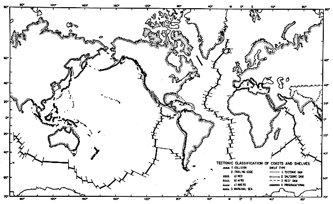 |
|---|
Arthur L. Bloom
A shoreline is the demarcation between subaerial and subaqueous landforms. A coastline specifies an oceanic shoreline. In the more general sense, a coast refers to a zone of indefinite width on both sides of the coastline, so we freely speak of coastal shipping, coastal highways, etc. By that usage, coastal landforms are those that are in any way influenced or controlled by proximity to the sea, such as the inland extent of salt spray that affects plants or soil (Bloom, 1978, pp. 435-437). Beyond that general statement, coastal landforms are difficult to classify. Many coasts are simply drowned portions of a subaerial landscape or exposed portions of the sea floor, on which the position of the coastline is the random result of land uplift or subsidence or of a rise or fall of sea level.
Although hard to define and transient in time and space, a coastline has profound geologic implications. Above sea level, all land must be eroded by rain, rivers, wind, and glaciers. The coast marks the line at which the erosion products are dropped and become new marine sedimentary deposits. Thus the coastline denotes the transition from net erosion to net deposition on our planet.
Coasts are also the loci of a unique assemblage of erosional and depositional processes (Shepard and Wanless, 1971). A global survey of wave and current energy in the coastal zone showed that there is 58 000 times more energy available to transport mud and sand in the nearshore marine environment than there is sediment to be transported (Inman and Brush, 1973). All this wave and current energy that is expended on coasts is normally restricted to a vertical zone between only about 10 m above and below mean water level. The upper limit is determined by tidal range and exposure to storm waves. The lower limit is determined by the rapid exponential decay of wave energy at relatively shallow depth. There is no "wave base" in the older sense of the term, but below a depth of about 10 m, most wave motion is too weak to transport sediment.
Because of the relatively narrow vertical range of coastal processes, a small change in the level of either land or sea can initiate an entire new cycle of coastal landform development and leave former coastal features as relict on emerged or drowned topography. Especially during the last 2 million years of perhaps twenty ice ages, sea level has fluctuated through more than 100 m each time glaciers expanded and retreated. Few if any coastal landforms show the morphologic relief of a single set of processes. Almost every coast shows a complex history of emergence and submergence, each episode putting its unique imprint on the land.
The events of the last 125 000 years are especially well recorded on coasts. The last Pleistocene interglacial age was about that long ago, and sea level was probably a few meters higher then: 6 m is an often-cited estimate. That interglacial period may have lasted about as long as the present "postglacial" or Holocene Epoch. Landforms were eroded and built on a scale very similar to those now forming, but at a slightly higher level. With the onset of the last ice age, sea level fell in a series of oscillations to a minimum of perhaps -120 m only about 18 000 to 15 000 years ago. Interglacial coastal sediments were vegetated, weathered, soil- covered, blown away, or dissected by erosion. As the sea has returned almost to its previous level, it has partly reoccupied the coastal zone of the last interglacial age. If the Pleistocene deposits had been lowered only a few meters by tectonic subsidence or erosion, they would have been reworked by Holocene coastal processes and buried by Holocene deposits. In other places, Pleistocene barrier beaches or wave-cut cliffs are separated by only a low scarp or step down to their modern analogs. Few coasts preserve the record of interglacials older than the last one. Perhaps the last interglacial of 125 000 years ago was slightly higher than earlier ones, and that contributed to its common preservation. Numerous examples are cited in the Plate captions for this chapter.
| Figure 6.1. Worldwide distribution of tectonic coastal and shelf types. | |
|---|
No classification of coasts is widely accepted because the forms are almost always compound in their origin. One proposed by Shepard in 1937 and subsequently modified (Shepard, 1973) is followed in a general way in this chapter. He recognized the global impact of the Holocene rise of sea level and distinguished primary coasts as those that had simply been drowned with minimal modification by marine processes and secondary coasts as those that were subsequently modified by marine erosion or deposition.
Another current classification of coasts is based on their plate/tectonic setting (Figure 6-1) (Inman and Nordstrom, 1971). Collision coasts are at the colliding or converging margins of continents or island arcs. Trailing-edge coasts of several types evolve on passive continental margins, initially as rift-bounding fault-scarp coasts, then later as maturely dissected fault scarps fronted by narrow coastal plains, and still later in the evolutionary sequence as broad sedimentary coastal plains. Marginal sea coasts are primarily on the depositional edges of shallow marginal or epicontinental seas. Based on the tectonic environment, Inman and Nordstrom devised a morphologic classification of coasts (Figure 6-2) that uses simple descriptive phrases for the gross regional landscape of each tectonic type. The classification has problems; for example, there is no collision in progress along the western side of South America, yet the Andes Mountains are actively rising. Also, to label the entire coast of the Arctic Ocean as "glaciated" is neither true nor consistent with the variety of tectonic activity in the region. Nevertheless, the classification of Inman and Nordstrom is useful and important because it links coastal landforms to important categories of tectonic landforms.
The simplest coasts are probably those on continental shields or cratons, where in many places long continued subaerial erosion has reduced the landscape to near sea level, and the sea, in its present postglacial time of relatively high level, has drowned a fluvial, glacial, volcanic, depositional plain, or other landscape (Plates C-1, C-2, C-3, C-4, and C-5). In such places, coastal landforms are the result of a minimal impact of nearshore marine processes. For the most part, they are simply the result of sea level coming to rest against a preexisting landscape. Lowland drainage systems are particularly susceptible to drowning as sea level rises, producing estuaries that severely indent otherwise regular coastlines (Plate C-23). Mountain ridge crests or hill summits then create peninsulas or islands, separated by drowned former valleys (Plates C-6, C-7, and C-11). If the valleys were shaped by glaciers, their drowned counterparts have become fjords (Plate C-5). Many of our most scenic coastal landscapes (New England, Norway, Ireland, and New Zealand) owe their beauty to the rapid changes when a subaerial landscape suddenly became coastal at the end of the last ice age, only about 10 000 years ago.
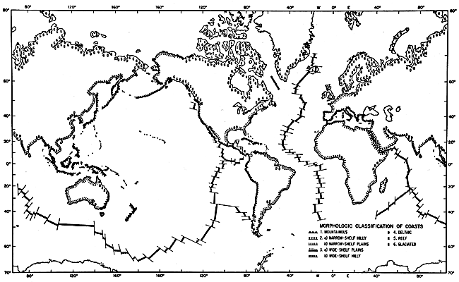 |
Figure 6.2. Worldwide distribution of morphologic coastal types. |
|---|
Structural and tectonic lineaments in a subaerial landscape also control the shoreline shape, especially where the land is partly drowned (Plate C-7). The Atlantic type of coast (Plate C-7) was defined a century ago by the German geologist, E. Suess (1888), who recognized the truncated structures now explained by continental separation and ocean-floor spreading. Other coasts, such as in Peru or the Dalmation Coast of Yugoslavia (Plates C-8 and C-12), are of the Pacific type, in which active mountain building is creating folds and faults parallel to the coast. Islands on such coasts as the Makran region of Iran and Pakistan are the crests of fault blocks or rising anticlines that are uplifting and folding the seafloor at converging continental margins (Plate C-9).
On the passive trailing coastal margins of continents, rivers drop their loads of sediments, which are then shaped into deltas or a variety of progradational landforms. Mud may be trapped by vegetation to form extensive coastal salt marshes (Plates C-13 and C-14) or tropical mangrove swamps (Plates C-3, C-4, and C-15) Sand is more likely than mud to move laterally along coasts to build a variety of beach landforms (Plates C-4, C-13, and C-14). Approximately 13 percent of the world's coasts are said to be sandy barrier beaches, primarily constructional in nature (Zenkovich, 1967, pp. 288 and 390).
An extremely abundant but nevertheless remarkable coastal landform type is that built by biogenic deposits of shallow- water marine animals such as corals (Plates C-16 through C-19). Entire island archipelagos and a very large percentage of the world's coasts have been constructed of coralline limestone (Davies, 1980, p. 5), forming reefs that fringe or protect other coastal landforms. The largest of these, the Great Barrier Reef of Australia (Plate C-18), extends for 2300 km along the tropical northeast coast of Australia, inhibiting wave erosion of the mainland coast and creating a huge but unique coastal landform assemblage.
The reader interested in more information on the coastlines of all continents should consult the recently published The World's Coastlines (E. C. F. Bird and M. L. Schwartz (Eds.), 1071 pp., Van Nostrand Reinhold Co., New York, 1985).
Continue to Plate C-1| Chapter 6 table of Contents| Return to Geomorphology Home Page| Complete Table of Contents|