 |
 |
|---|---|
| Plate C-3 | Map |
|
|
|---|---|
| Plate C-3 | Map |
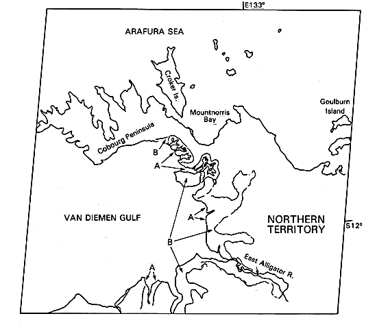
The northernmost part of Australia (Arnhem Land) faces onto the Arafura Sea toward the eastern Indonesian archipelago. The shallow epicontinental sea, poorly charted and strewn with isolated reefs and waterless islands, was mostly dry land during the low sea level of the ice ages.
The ancient shield of the Australian continent has been eroded to its roots. On the Cobourg Peninsula, a thin cover of Mesozoic sandstone covers the crystalline basement. Nowhere is the relief greater than 500 m, and several kilometers inland, the land may be only a few meters above sea level.
The vegetation of the Northern Territory is a dry savanna. Torrential rains fall during the summer cyclone ( = hurricane or typhoon) season, but during much of the year, the plains are hot and dry. Eucalyptus trees and acacias grow in sheltered places below rock ledges. The rocks are deeply weathered, often to an iron-oxide residue called laterite that in some places is pure enough to be loaded directly into ships as iron ore. Elsewhere, a comparable residual soil rich in aluminum oxide is the commercial ore of aluminum, bauxite.
| Figure C-3.1 | Figure C-3.2 |
|---|---|
 |
 |
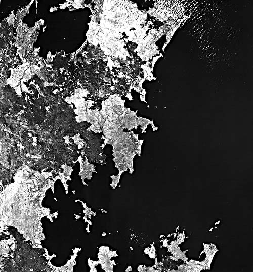
As evident in this Plate and in Figure C-3.1 (Cape Wessel, 300 km to the east), the subdued deeply weathered continental relief has been drowned by the postglacial rise of sea level. No extensive valley systems have developed because of the brief seasonal runoff and the subdued topographic relief, but a few valleys are outlined by the dark red reflectance of trees in this false-color image. In particular, areas of intertidal mangrove swamp (A) fringe the shoreline and fill two extensive tidal basins on the south side of the peninsula.
In the more humid tropics, mangroves form a thick forest within the intertidal zone. These remarkable trees, members of several plant families, have convergently adapted to life in a saline environment with varying degrees of tidal flooding (see also Plate C-15). Root structures are adapted to provide oxygen through spike-like upward projections. Prop roots support the trees in soft mud. Some species even hold their seeds on the tree until the seed has sprouted two leaves and a substantial protoroot so that, when it falls into the sea upright and floats off, perhaps it will ground in a mud flat and begin a new life. These are among the few plants that can be said to be viviparous, or bearers of live young.
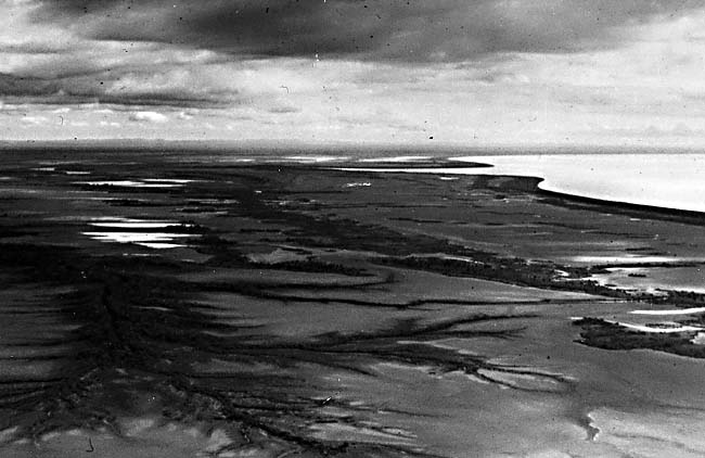
In the dry savanna region of northern Australia, evaporation in tidal pools creates high salinity and temperatures that even mangroves cannot tolerate. There, a thin border of mangrove jungle, sometimes only a few trees wide, fringes the shoreline, perhaps rooted in a sandy beach ridge where rainwater can occasionally dilute the saline ground water. Immediately behind the mangrove fringe are harsh white salt-encrusted tidal flats that may be several kilometers wide (B) (Figure C-3.2, an aerial photograph covering the left-most land in Plate C-3). Near the center of Plate C-3, episodic high water floods 30 km inland to fill a shallow basin almost 16 km in diameter. In this view, the tidal creeks and the edge of the basin are outlined by a thin line of red-reflecting mangroves. Figure C-3.3 shows a similar scene from the air near Princess Charlotte Bay.
| Figure C-3.3 | Figure C-3.4 |
|---|---|
 |
 |
This is one example of a drowned subaerial landscape in which the lower parts of dendritic branching river valleys are and only the former headwaters remain above present sea level. The pattern is called skeletal because only the branching ridge crests are exposed. Cobourg Peninsula shows progressively more submergence from east to west, possibly because of recent westward downwarping.
In the Arafura Sea north of the peninsula, this late September (springtime) scene shows ribbons or streamers of algae streaking the surface. Strong easterly trade winds blow at this time of year, creating the ocean surface pattern.
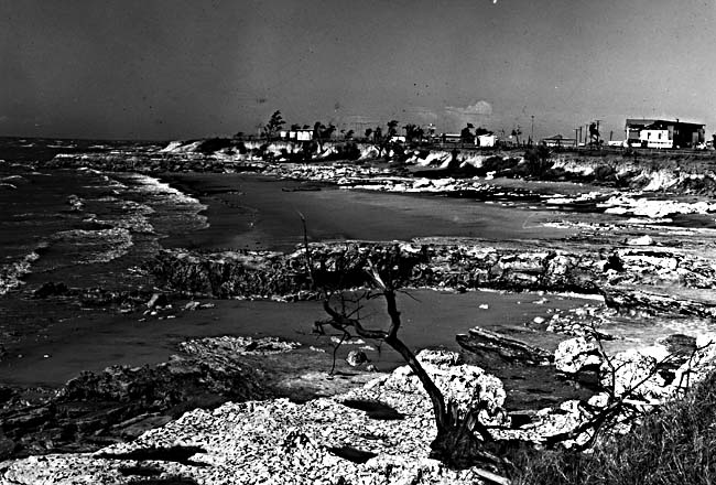
Minor coral reefs fringe the rocky coast wherever mud is not brought in by tidal creeks. Especially on the north coast of Cobourg Peninsula, small fringing reefs are abundant (Figure C-3.2). Multiple beach ridges have extended some of the headlands, as in the north center of Figure C-3.2, and other headlands have wave-cut platforms (Figure C-3.4). Elsewhere, prograded beach ridges enclose and smooth the outline of bay heads. The beaches have probably formed in Holocene time, with a chronology similar to those on the coast of New South Wales (Plate C-2). Landsat 1069-00442, September 30, 1972.
Continue to Plate C-4| Chapter 6 Table of Contents.| Return to Home Page| Complete Table of Contents|