 |
 |
|---|---|
| Plate C-6 | Map |
|
|
|---|---|
| Plate C-6 | Map |
West Falkland Island is a "skeleton island," defined as an embayed island, "characterized by a narrow and serrate axial ridge or backbone with slender lateral spurs or ribs; and the ribs enclose open bays" (Davis 1928, p. 197; Cotton, 1969). The island is continental in structure, a fragment of the ancient Gondwana supercontinent that broke up in the Mesozoic Era. The Falkland Islands are a piece of continental crust that was left behind as South America moved westward from Africa. The surface rocks are Paleozoic and Mesozoic quartzites and sandstones, folded and faulted in an intricate pattern that controls outline of the two large Falkland Islands and innumerable smaller ones.
The intricate skeletal outline of West Falkland Island shown in the image is primarily the result of subaerial erosion, drowned by the postglacial rise of sea level. During glacial times, the Falklands were a range of hills on the emerged Argentine continental shelf 600 km east of Patagonia in southern Argentina. The climate of the Falklands then was even colder than now, yet the present islands were only lightly glaciated by small cirque glaciers on the highest peaks (Clapperton, 1971). The islands were intensely affected by periglacial process, however. The term "solifluction" was coined by Andersson (1906) to define the dominant slope process of the Falkland Islands.
| Figure C-6.1 | Figure C-6.2 |
|---|---|
 |
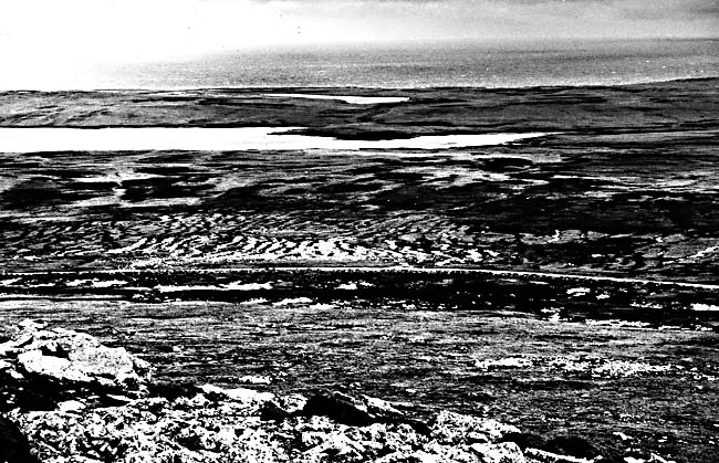 |
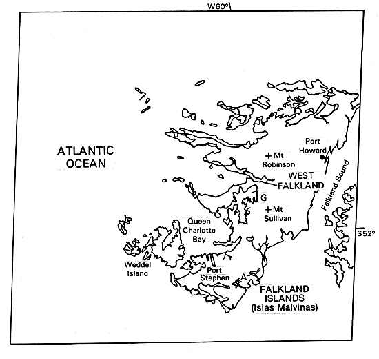
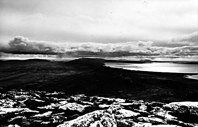
The combination of folded arenaceous sedimentary rocks and intense solifluction created broad low gradient valleys, residual ridge crests capped by tors or low cliffs, and cirque-like "theater-headed" semicircular valley heads (Figure C-6.1). The lowlands were engulfed by masses of saturated sediments that flowed down from higher slopes (Figure C-6.2). When drowned by the postglacial rise of sea level, the valley systems were dismembered, with ridge crests of resistant rock becoming islands or long sinuous peninsulas. The image clearly shows islands and peninsulas that can be traced into strike ridges across the interior of West Falkland Island. Between them are broad shallow valleys full of ponds and marshes. Major fracture systems that were etched out by subaerial erosion create deep narrow coves along the coast and on the shores of the inland lakes. An especially prominent rock outcrop forms a nearly continuous coastal ridge along Falkland Sound on the northern two- thirds of the east side of West Falkland Island (Figure C-6.3). The small village of Port Howard is on a long narrow harbor behind the prominent ridge.
| Figure C-6.3 |
|---|
 |
Like the coast of Ireland (Plate C-7), the coast of West Falkland Island is of the Atlantic type, in which structural ridges are truncated by the present shoreline as though fragments from a preexisting mass. The much finer erosional texture of West Falkland Island is due to the unique response of the rock types to intense frost action and solifluction. Even relatively narrow intersecting fracture zones (A) were etched out and are now narrow branching marine coves.
Intense glaciation would have smoothed the outline of West Falkland Island and created deep straight-sided fjords (as in Plate C-5) instead of narrow crooked inlets. Why the Falkland Islands escaped glaciation is not clear, when Patagonia and nearby sub-Antarctic islands carried full ice caps. Perhaps the exposed Argentine shelf and the rain shadow of the Patagonian ice cap blocked moisture from reaching the islands. Landsat 31510-12502-6, April 23, 1982.
Continue to Plate C-7| Chapter 6 Table of Contents.| Return to Home Page| Complete Table of Contents|