 |
 |
|---|---|
| Plate KL-11 | Map |
|
|
|---|---|
| Plate KL-11 | Map |
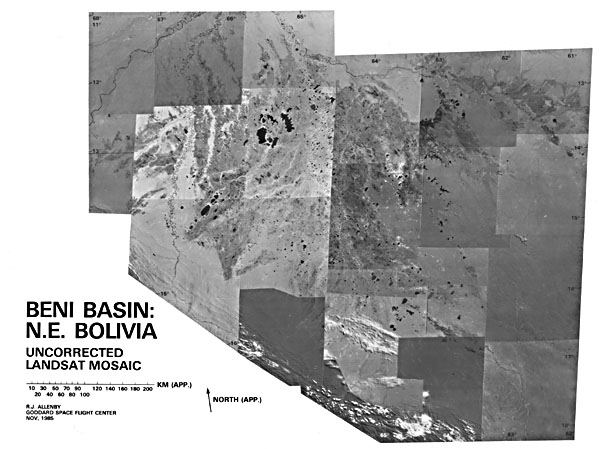
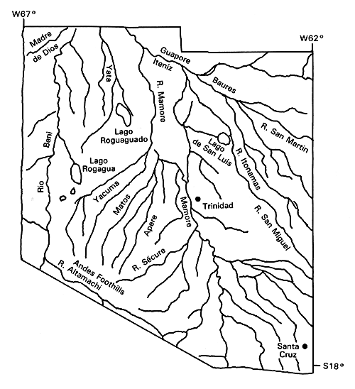
This uncorrected Landsat mosaic illustrates the Beni Basin, which is located west of the Brazilian Shield between the northwest-trending Andean Cordilleras and the Brazilian border. This Basin, which covers most of northeastern Bolivia, constitutes the transition zone between the extensive cratonic region of the Brazilian Shield and the Andean Foredeep or piedmont. The drainage from this huge swamp area, one of the largest in the world, finds its way into the Rio Madeira, which joins the Amazonas River downstream from Manaus, Brazil. An unusual feature of the region is the large number of rectangular straight-edged, often aligned lakes that are contained in an area of roughly 250 000 km2.
Unfortunately, very little geological information is available about this inaccessible area, which is impassable in the rainy season and, in the dry season, is traversable only by means of a few Indian trails. The only detailed publications of the region easily available in the literature are by Plafker (1964, 1974), who made use of partial airphoto coverage, limited ground surveys, and the results of several exploratory wells. According to Plafker, the Basin is exceptionally flat, the stream gradients are extremely low (less than 20 cm/km), and the water table is less than 1 meter from the surface. Most of the Basin is covered with grassland or reeds, the trees being restricted to the "higher" natural levees rising 1 meter above the plains. Based on soundings in seven lakes and reports from local inhabitants, Plafker (1964) reports that the lakes in cross section are steep-sided with shallow flat bottoms. The deepest lake (10 by 6 km) he sounded had a maximum depth of about 2.5 meters. Basement underneath the Basin sediments appears to be the Brazilian Shield, which plunges to a depth of over 5.5 km along the edge of the Foothills Belt. Seismic results indicate that sediments are flat, lying over a relatively smooth basement undisturbed by any large vertical faults. Stratigraphic drill holes show that the cover consists of poorly consolidated continental sediments of clay, sand, and silts of Quaternary and possible Late Tertiary ages.
| Figure KL-11.1 | Figure KL-11.2 |
|---|---|
 |
 |
Because some of the lakes occur on the outcropping Brazilian Shield, their formation cannot be attributed to characteristics within the sedimentary column. Instead, it is believed that the Beni lakes reflect a basement (Shield) fracture pattern projected upward through the sediments. The regional drainage pattern further suggests that this fracture pattern has been enhanced by a broad, gentle tectonic uplift occurring across the basin. This upwarping would generate tensile conditions in the basement and facilitate subsidences or sags of fault-bounded basement blocks. The fracture pattern (and uplift) are also compatible with wrench-faulting induced by the faster western motion of the Brazilian Shield relative to the Andean Cordillera.
Globally, the Beni lakes, although unusual, are not unique. Clustered, oriented lakes occur in the Carolina Bays (Plate KL-10), along the Arctic Coastal Plain of Alaska (Plate KL-9), in the Mackenzie Delta of Canada (Plate D-10), and in northwestern Siberia (Plate KL-8). These lakes are generally oval or elliptical in horizontal section and basin-shaped in cross section. Although controversial, the formation of these lakes is attributed primarily to strong wind action, with the long axis of the lakes being perpendicular to the prevailing wind direction. Only the lakes in the Old Crow Plain of the Canadian Yukon closely resemble the Beni lakes. The Old Crow lakes occupy a much smaller area (approximately 7000 km2), but are strongly rectangular in shape with shallow flat bottoms.
| Figure KL-11.3 |
|---|
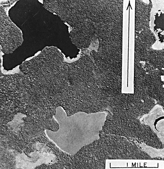 |
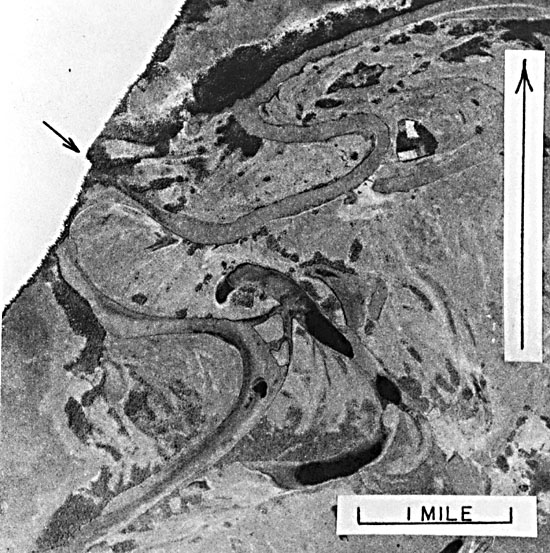
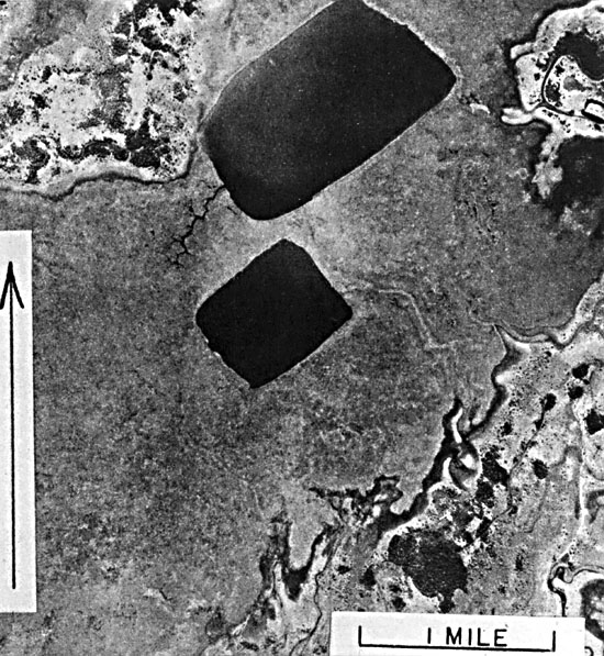
Figure KL-11.1, Figure KL-11.2, and Figure KL-11.3 (courtesy of George Plafker) are high-altitude vertical airphotos of individual lakes. In Figure KL-11.2, a large lake cuts across an abandoned channel of the Rio Beni (large river on west side of Basin). The arrow indicates a lateral displacement of shoreline along a northwest-trending lineament. Figure KL-11.2 illustrates a region in the center of the lake region, and Figure KL-11.3 shows a lake near the margin of the Brazilian Shield. (GCW: R. Allenby) Landsat Mosaic.
Continue to Plate KL-12| Chapter 7 Table of Contents.| Return to Home Page| Complete Table of Contents