 |
 |
|---|---|
| Plate KL-8 | Map |
|
|
|---|---|
| Plate KL-8 | Map |
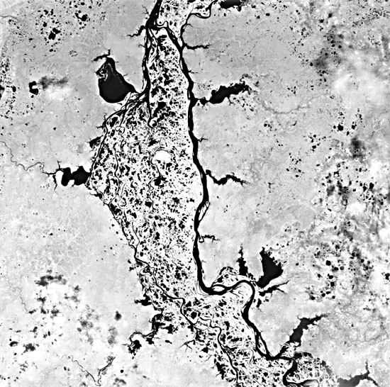
This Landsat scene is of the Ob River (Figure KL-8.1) about 170 km from where it enters the Obskaya Gulf, an arm off the Kara Sea (part of the Arctic Ocean). The river originates in the Altai Mountains near the Russian/Chinese border, where it then flows north for over 4000 km through the Western Siberian Lowland. The northern edge of the image is only 50 km south of the town of Salekhard, the largest nearby community. The Ob River is frozen about 220 days of the year but thaws in May and June (Suslov, 1961). These thaws are accompanied by ice jams that hinder navigation until late June. In general, the aridity of the Western Siberian Lowland increases from the west to the east. In this part of Siberia, the rainfall is 30 to 50 cm/yr, which falls mostly in the summer. The flatness of this part of Siberia is indicated by the gradient. In the last 2900 km of the Ob River´s trek to the sea, it drops only 91 m (Suslov, 1961).
| Figure KL-8.1 | Figure KL-8.2 |
|---|---|
 |
 |
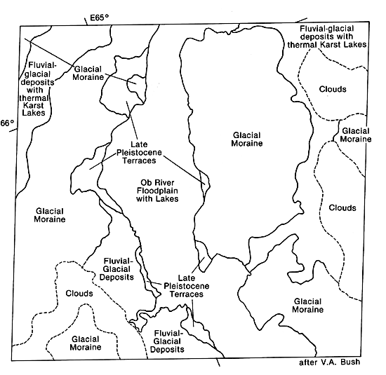
The Western Siberian Lowland is a structural basin with more than 1000 m of Tertiary cover overlying several thousand meters of Mesozoic and Paleozoic rocks. Few structures of any consequence are expressed topographically in the region, although some of the drainages in the plate image area appear to be influenced by fracture trends (index map). This region was inundated during the last glaciation by a vast glacial ice sheet that moved southeast. The image area is mantled with fluvial- glacial deposits and glacial moraines (Bush, 1985, written communication).
In this Landsat image, the Ob River displays a braided channel and anastomosing network across its floodplain. Numerous lakes are scattered both within the floodplain and just outside the floodplain. Suslov (1961) classifies the lakes within the Western Siberian Lowland as primary (geological origin), glacial (kettle lakes), alluvial (oxbow, abandoned high-water channels and crevasse lakes), peat-bog, and suffusion lakes (due to the winnowing out of fines and subsequent hydrocompaction). Most of the lakes displayed in the floodplain are probably abandoned high-water channels. Some crevasse lakes may also be evident (the large lakes around the periphery) and are possibly influenced by a natural levee system adjacent to the floodplain. Some of the lakes to the east and northwest of the image are thermokarst lakes, which are not recognized by Suslov, but have been noted by Bush (1985, written communication).
| Figure KL-8.3 |
|---|
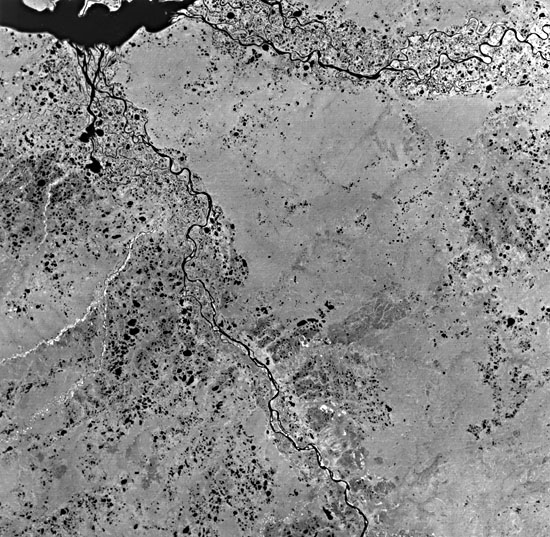 |
Thermal karst lakes form through the melting of ground ice accompanied by surface collapse to create a depression that subsequently fills with water (Washburn, 1980). This type of lake has been studied extensively in eastern Siberia near the Lena River (Czudek and Demek, 1970). A profusion of these lakes can be seen in Figure KL-8.2, a Landsat image taken southeast of the Plate image. The lakes in this figure are confined to the interfluves and are circular to slightly elliptical with the long axis trending east-west. The axis is perpendicular to the prevailing north wind (Suslov, 1961). These lakes bear a strong resemblance to the Carolina Bays found in North and South Carolina.
The thermal karst lakes in the Plate image are confined to fluvial-glacial deposits as mapped by Bush (1985, written communication). Similar lakes occupy the uplands around the Yenisey River to the northeast (Figure KL-8.3) as it enters the Yeniseyskiy Gulf on the Kara Sea. Landsat 1387-06402-7, August 14,1973.
Continue to Plate KL-9| Chapter 7 Table of Contents.| Return to Home Page| Complete Table of Contents