 |
 |
|---|---|
| Plate E-22 | Map |
|
|
|---|---|
| Plate E-22 | Map |
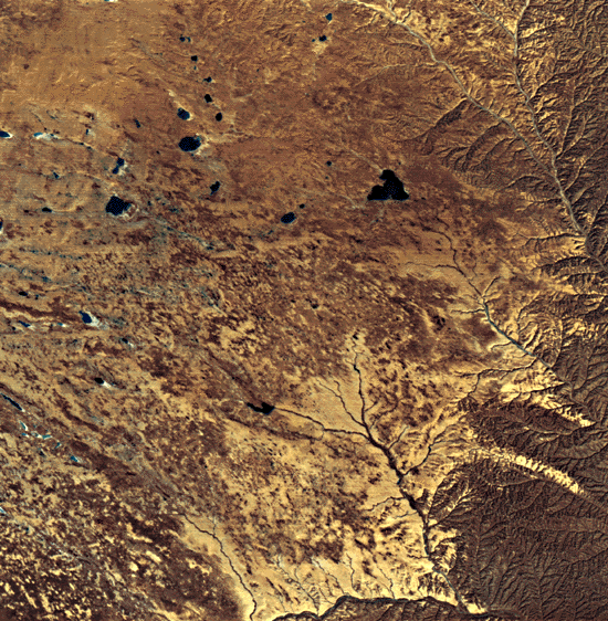
The Mu Us Sandy Land is a 32 000-km2 desert region on the Ordos Plain in central China. This low-relief desert reaches an elevation of about 2000 m above sea level. Dunes in the Mu Us average 3 to 5 m in height, but some may be as high as 20 m (Zhu et al., 1980). These authors map the dunes as crescentic and linear chains oriented toward the northeast. Inasmuch as these features are below the limit of resolution in the Landsat image, the Mu Us Sandy Land appears in this scene to consist of sand sheets. A few small linear dunes maybe seen south of the stream in the left center of this Plate. The dark tone of some of the dunes suggests that they are semifixed (partly vegetated).
Because of the presence of archaeological ruins and other evidence of formerly wetter climates, many Chinese scientists consider some of the deserts in central and eastern China to be man-induced (Zhu et al., 1980), and sometimes refer to them as sandy lands. The Mu Us Sandy Land is cited frequently as one of the most desertified areas of China. Incursions of pastoralists since the 9th century B.C., exploitation of the floodplains of the Yellow River, and poor farming practices destroyed the delicately balanced ecosystem of the steppe environment and allowed the desert to encroach. Li (1979) reports that ruins of the capital of the Xia dynasty (2205-1766 B.C.) and 11 other large cites are now covered by the moving dunes of the Mu Us. As seen in this Plate, today the desert consists of large areas of irregularly shaped sand sheets and streaks interspersed with numerous small lakes, some of which are salty. Approximately 50 percent of the Mu Us is marshland or farmland covered with vegetation.
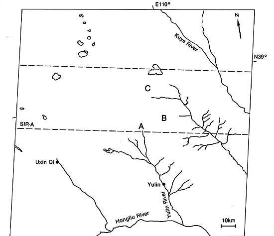
The eastern section of the Mu Us Sandy Land and the western section of the Loess Plateau of China are seen respectively in the left and right of the Plate. This Plate reveals a striking difference in drainage patterns between the Loess Plateau and the Mu Us Sandy Land. This also shows up in Figure E-22.1, a SIR-A radar image. The sandy areas in the Landsat image are light, whereas on the radar, they are dark. The streams on the right half of the Plate drain into the Yellow River, just a few kilometers east of the scene. Note how much sharper some of the drainage patterns are on the SIR; compare point A on the Landsat with the equivalent point on the radar. The reflectance differs sharply on the radar, perhaps because of a change in the slope or vegetation type of the stream channels.
| Figure E-22.1 |
|---|
 |
In an effort to reclaim the sandy lands, the residents of the Mu Us have developed a method for stabilizing the dunes. First, shrubs are planted on the lower one-third of a dune´s windward side. The vegetation lowers the wind velocity near the bottom of the dune and prevents much of the sand from moving up the dune. Higher velocity winds at the top of the dune level it off. Then trees are planted on top of the flattened dune. Within 5 years, this method of controlled planting can increase vegetation cover as much as 50 to 80 percent.
Another technique for reclaiming deserts used in many of the sandy lands of China is to build kuluns. These are enclosures to control grazing and to allow the land to recover from misuse. Pastures and forests inside the kuluns block the wind and improve the quality of the soil. Kuluns maybe constructed to provide grazing or fodder, to control sand movement, or to turn swampy areas between dunes into productive land. Desert marshes may be upgraded by planting belts of tall trees perpendicular to the main wind direction, by planting grasses in the shelter of the trees, and by developing irrigation channels using the groundwater resources. Dunes inside a kulun may be leveled manually or by the wind, thus reducing the topographic relief.
| Figure E-22.2 |
|---|
 |
Although the kuluns of the Mu Us are not visible in this Landsat image, they are scattered throughout the desert, as can be seen in the SIR-A image. Compare points B and Con the Plate and on the SIR image. In the SIR view, we may be seeing the barbed-wire fences that are creating the enclosures.
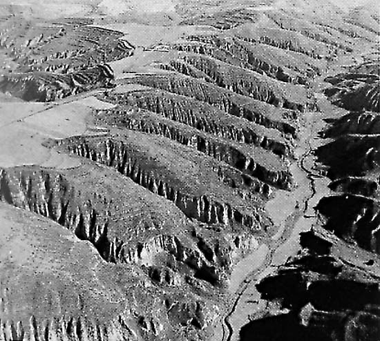
Figure E-22.2 is an oblique aerial photograph of the Loess Plateau acquired about 200 km east of this Plate. As in the Plate, the plateau is deeply dissected in a dendritic drainage pattern. Note how the streams are eroding the plains. Landsat 30203-02430-7, September 24, 1978.
Continue to Plate E-23| Chapter 8 Table of Contents.| Return to Home Page| Complete Table of Contents