 |
 |
|---|---|
| Plate E-25 | Map |
|
|
|---|---|
| Plate E-25 | Map |
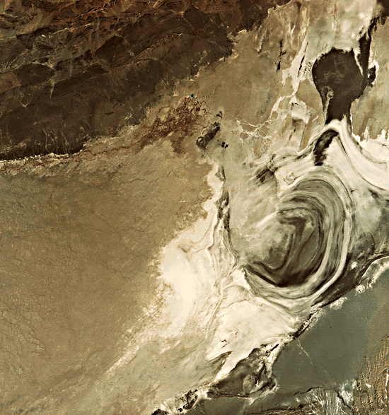
Lop Nur, in the eastern Tarim Basin, was identified in ancient Chinese records and maps as a salt lake 150 km in diameter (Xia, 1982). Today, it is a totally dry lake bed with a salt crust 30 to 100 cm thick. The concentric rings created by the progressively shrinking shorelines of the lake resemble a giant ear when viewed from space. Water has probably most recently been in the dark center of the ear. The dark areas north of the ear are also lacustrine plains, perhaps containing some water at this time of year.
At an elevation of about 780 m above sea level, Lop Nur is the main drainage playa of the Tarim Basin. The Tarim River, Plate E-26, flows into Lop Nur. The mean annual precipitation at Lop Nur is generally less than 20 mm (Zhao and Xia, 1984).
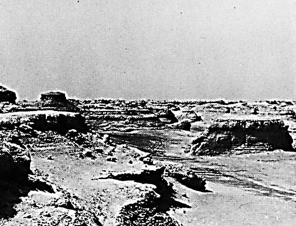
Yardangs, sculpted landforms streamlined by desert winds, were first described in this locality by Hedin (1903). The yardangs in Figure E-25.1 are near the ruins of Kroraina in the center of the Plate. Note the heights of the yardangs and the flatness of the intervening depressions. Some of the horizontal beds have been undercut and have collapsed on the slope of the yardangs. Compare these yardangs with those on Plate E-19, the Lut Desert. Xia (1982) estimates that 5.3 m of surface was eroded in Lop Nur between 1919 and 1959, although this may be geographically and temporally a local phenomenon. He also points out that some of the yardangs extend in the apparent directions of former floodwaters of Lop Nur, and cites some evidence of floodwater erosion on the yardangs. He hypothesizes that water may have played a significant role in shaping these yardangs.
| Figure E-25.1 | Figure E-25.3 |
|---|---|
 |
 |
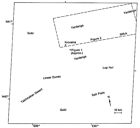
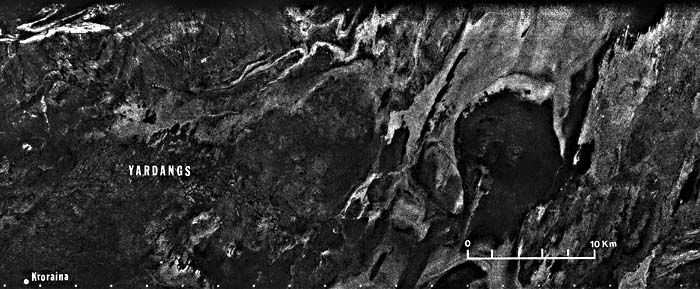
The influence of a northeasterly wind direction on elongation of the yardangs is readily apparent both on the Plate and in Figure E-25.2, a Space Shuttle radar image (SIR-A) of the area outlined on the index map. Although individual yardangs northwest of Lop Nur are discernible in the radar image, they are quite difficult to see on the Landsat image. Dark intermittent stream channels are likewise visible as they pass across the yardangs on the radar image.
Until the 4th century A.D., Kroraina, also known as Loulan, was a major stop on the Silk Road. Fish from rivers emptying into Lop Nur, as well as cattle and game from the surrounding grasslands, fed this city of more than 10 000 people (Mu, 1981). Today, the area is a desolate wasteland with a few ruins left to mark the once- flourishing metropolis that is still reachable only by camel.
| Figure E-25.2 |
|---|
 |
Xia (1982) describes the Lop Nur area as an undulating crust of salt stretching in every direction. Figure E-25.3 illustrates the salt crust of the desert. Zhao and Xia (1984) note that salt crusts and saline soils occupy about 35 percent of the Lop Nur environment. Landsat 1162-04134-7, January 1, 1973.
Continue to Plate E-26| Chapter 8 Table of Contents.| Return to Home Page| Complete Table of Contents