 |
 |
|---|---|
| Plate E-26 | Map |
|
|
|---|---|
| Plate E-26 | Map |
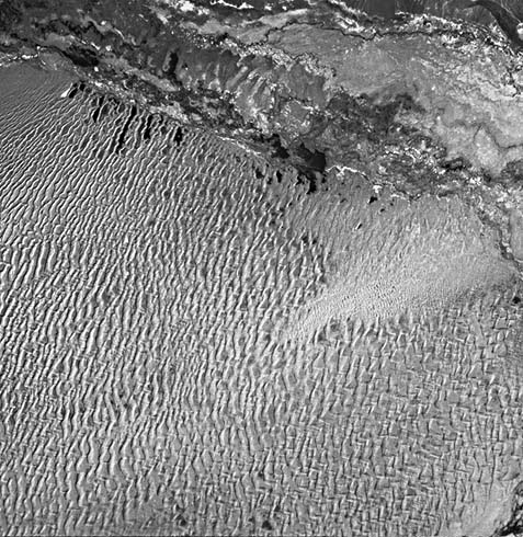
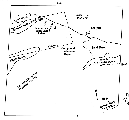
This Plate scene falls within the northeastern Taklimakan Desert of the Tarim Basin. Compare this Plate with Plate E-27, the color mosaic of the southwestern Taklimakan Desert, and with Plate E-25, Lop Nur, which is about 300 km east of this Plate. The Tian Shan Mountains are directly north of the Tarim River floodplain. The Qarqan River drains water from the Kunlun Shan, a mountain range at the southern border of the Tarim Basin.
Breed et al. (1979a) determined that the compound crescentic dunes in the center of this Plate are the largest such dunes in their worldwide study. The dunes have a mean horn- to-horn width of 3.2 km and a mean length of 2.2 km. They are spaced 3 km apart and average 100 to 150 m in height (Zhu et al., 1980).
Simple crescentic dunes in the right center of the Plate are encroaching westward over the large ridges (Breed et al., 1979a). Although these dunes are smaller, their orientation is identical to that of the larger dunes. Sand for these encroaching dunes may be derived from the floodplain of the intermittent Tarim River. The sand sheet north of these dunes also is encroaching on the large field, as can be seen by the muted crescentic dune forms under the sheet.
| Figure E-26.1 |
|---|
 |
Parallel interdunal lakes at the upper left of the Plate are directly south of the small channel of the Tarim. The wide lakes north of the Tarim River are reservoirs.
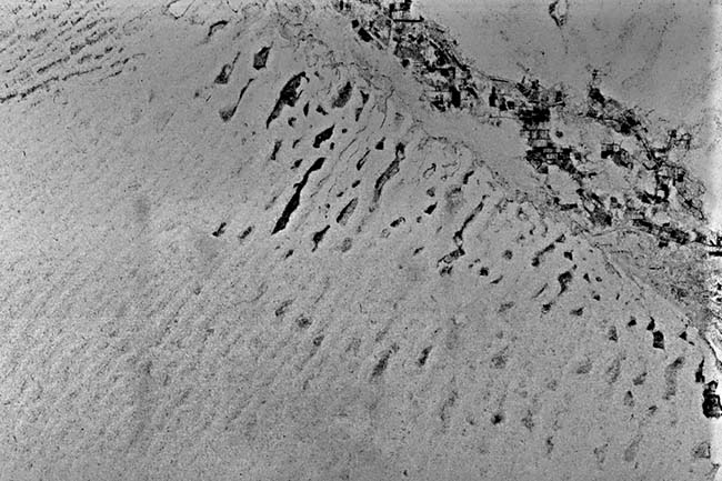
Figure E-26.1 is a 50-km wide SIR-A radar strip of the interdunal lakes and the desert. In radar imagery, smooth water, being a specular reflector, normally is black because of low signal returns. However, this strip had to be printed as a negative because of film density problems, so that these lakes now appear as lighter gray tones. The longest lake and the two on the far left are outlined by former lake levels in the strip. Compare this with the former lake levels at Lop Nur on Plate E-25. The sharply defined dark areas near the lakes in the radar image are interdunal playas that remain dark in the Landsat image. The bright areas north of the lakes in the radar strip are irrigated farmland.
The return signals in the radar image display a notable difference between the dunes associated with the lakes and the smaller simple linear dunes west of the lakes. Dunes commonly have a dark response on radar images typical of smooth surfaces unless the dunes have slipfaces oriented normal to the incident radar beam (Blom and Elachi, 1981). Because the slipfaces of these small dunes are almost normal to the SIR-A flight path, they are much brighter in a radar display than the larger dunes among the lakes.
| Figure E-26.2 |
|---|
 |
Observe the drainage pattern on the left side of the radar strip. Numerous buried drainage channels of the east- flowing Tarim River are readily visible in the radar image. Although one channel may be distinguished on a Landsat image directly west of this Plate, most of the other known channels cannot be recognized. That area is a sand sheet with occasional small dome-shaped dunes. Paleochannels of the Tarim River have been found about 80 km south of the present Tarim channel (Zhu, 1984). This image once again confirms the value of spaceborne radar for mapping paleodrainage channels.
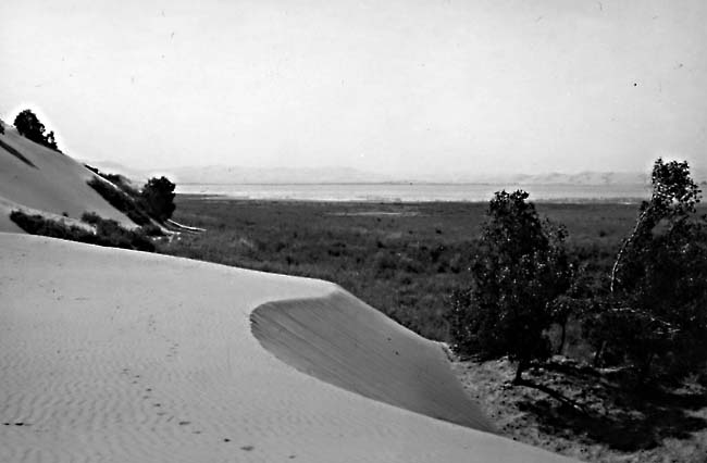
When Sven Hedin investigated this area in 1905, he found a total of 35 lakes that the local inhabitants claimed were artificially made in the interdune depressions. Hedin (1905) questions the artificial origin of these lakes. Because some of the lakes were fed by the Tarim River through connecting channels, he deduced that they were once fresh but became brackish when the channel was severed. Hedin points out that the lakes are young because the Tarim River has only recently begun to flow through that region. The lakes are doomed to perish through either the advancing of the dunes or the instability of the river (Hedin, 1905, p. 83). As the Plate scene illustrates, few of the original 35 lakes remain 80 years after his work. Figure E-26.2 shows the dune/water boundary on one of the lakes on the Plate. Note the vegetation on the floodplain and on the dune to the far left. Landsat 10074-04244-7, October 5, 1972.
Continue to Plate E-27| Chapter 8 Table of Contents.| Return to Home Page| Complete Table of Contents