 |
 |
|---|---|
| Plate G-15 | Map |
|
|
|---|---|
| Plate G-15 | Map |
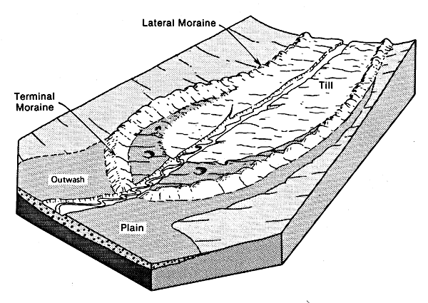
A terminal moraine is "the end moraine, extending across a glacial valley as an arcuate or crescentic ridge, that marks the farthest advance or maximum extent of a glacier; the outermost end moraine of a glacier or ice sheet. It is formed at or near a more-or-less stationary edge, or at a place marking the cessation of an important glacial advance" (Bates and Jackson, 1980; see also Figures 9-21 and 9-22a). A recessional moraine is "an end or lateral moraine built during a temporary but significant pause in the final retreat of a glacier. Also, a moraine built during a slight or minor readvance of the ice front during a period of general recession" (Bates and Jackson, 1980; also Figure 9-22a).
The grouping by Ritter (1978) of terminal, recessional, and lateral moraines under the single category of end moraines (Table 9-6) was discussed in the introductory part of the section on glacial and fluvioglacial deposition (p. 533 of this chapter). Although lateral moraines grade into terminal and recessional moraines, they also extend for a considerable distance up-glacier along the valley walls of a valley or outlet glacier, as will be examined separately in Plate G-16.
| Figure G-15.1 | Figure G-15.2 |
|---|---|
 |
 |
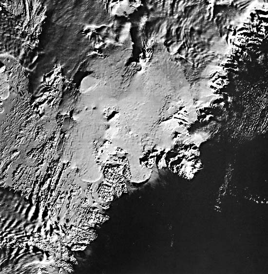
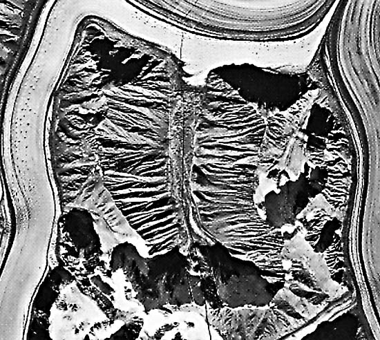
Although terminal and lateral moraines can have considerable lateral extent, a few to many tens of kilometers or more, their cross-sectional dimension is usually only a few tens of meters, although some are several kilometers wide (Plate G-21). End moraines also have a pronounced third dimension, usually a few tens of meters, and can be easily mapped on stereopairs of aerial photographs. On Landsat MSS images, however, which are in two dimensions and have a picture element (pixel) of 79 m, end moraines are difficult to map. Except in a few rare cases, only Landsat images of glaciated areas acquired at a low solar elevation angle provide a good opportunity to delineate terminal and recessional moraines.
This Plate is a Landsat image of part of south-central and southeastern Iceland. The image was acquired at a solar elevation angle of only 7° and with much of the land snow-covered. Landforms with subtle morphologic expression, such as terminal, recessional, and medial moraines, stand out because of shadows cast by the low Sun angle. Various terminal and recessional moraines visible on Plate G-15 are associated with the Hofsjökull and Vatnajökull ice caps, as seen in the index map. (Consult the index map for Plate G-6 for information on the geology and principal geographic features within the area encompassed by the image.)
| Figure G-15.3 |
|---|
 |
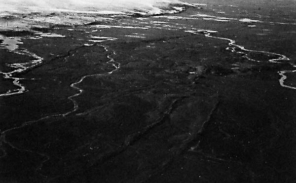
Subglacial volcanic calderas are noted at Kverkfjöll and Grímsvötn, both of which are discussed briefly in the section on subglacial volcanoes (Figure 9-14). Collapse cauldrons caused by subglacial volcanic and or geothermal activity are identified west of Grímsvötn. A comprehensive discussion of Plate G-15 is found in Williams and Thorarinsson (1974) and Thorarinsson et al. (1974). Plate G-6 is a Landsat MSS false-color composite of the same area in late summer, which should be used for comparison. Terminal moraines can be seen at the following outlet glaciers of Vatnajökull: a belt in front of Skeidarárjökull (A), single moraines in front of Sídujökull (B), on the northwest margin of Vatnajökull (C), and on the northeastern margin of Hofsjökull (D). Recessional moraines are visible at Múlajökull (E) (Figure G-15.1), a prominent outlet glacier of Hofsjökull, and along the eastern margin (F) of Hofsjökull (Figure G-15.2). Figure G-15.2 is a view looking north-northeast with the lobe of an outlet glacier in the left background. Note the V-shaped angle of the moraines, which resulted from the arcuate merger of two lobes from Hofsjökull. Arcuate medial moraines are visible on Dyngjujökull (G) (Figure G-16.2) and north of Breidamerkurjökull (H). On the late summer image of the area (Plate G-6), none of the end moraines can be detected, only the two medial moraines. The medial moraines are visible on summer images because the morainal material contrasts so sharply with the surrounding ice. On the wintertime image (Plate G-15), the medial moraines, although snow-covered, stand out sharply because of their relief, which is accentuated by the shadow cast by the low angle (7°) of solar illumination. Although of less relief than the medial moraines, the terminal and recessional moraines also are visible under the low solar angle of illumination.
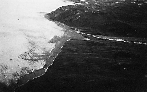
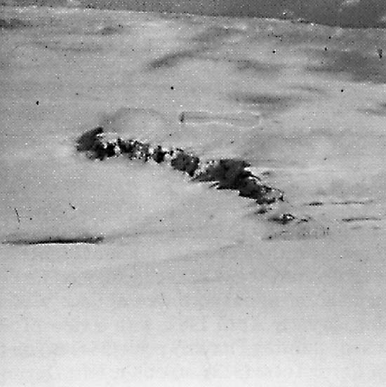
Figure G-15.3 is a southward-looking view of a terminal moraine on the west side of the Greenland Ice Sheet approximately 40 km east of the head of Søndre Strømfjord described in the section on fjords (Plate G-14). The edge of the Greenland Ice Sheet, where the photograph was taken, is shown by that Plate. Landsat 1192-12084-7, January 31, 1973.
Continue to Plate G-16| Chapter 9 Table of Contents.| Return to Home Page| Complete Table of Contents|