 |
 |
|---|---|
| Plate G-22 | Map |
|
|
|---|---|
| Plate G-22 | Map |
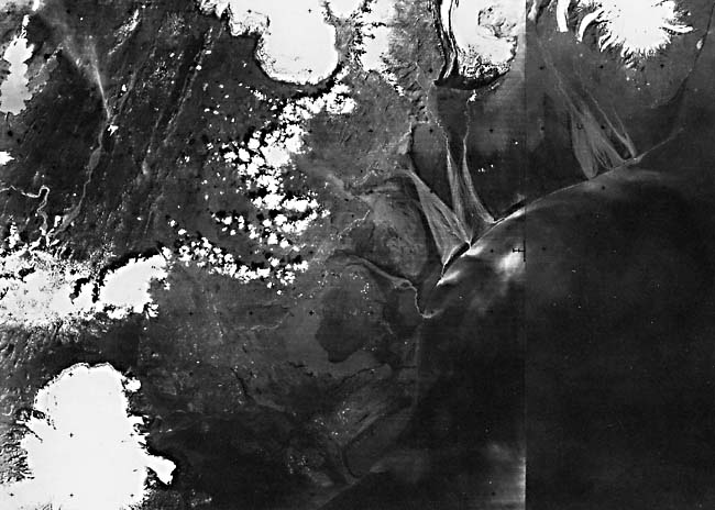
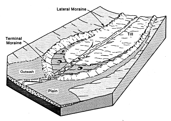
An outwash plain is defined as "a broad, gently sloping sheet of outwash deposited by meltwater streams flowing in front of or beyond a glacier, and formed by coalescing outwash fans" (Bates and Jackson, 1980). Bates and Jackson also define an outwash fan as "a fan-shaped accumulation of outwash deposited by meltwater streams in front of an end moraine of a glacier. Coalescing outwash fans form an outwash plain" (see Figures 9-21 and 9-22a). A synonym for outwash plain is sandur, an Icelandic loanword meaning the broad plain formed by the deposition of glacially derived sediments in front of the margin of a glacier. The sandur (sandar is the Icelandic plural) landform is especially well developed along the south-central coast of Iceland, particularly in the 110 km of the coastal plain that lies between the eastern margin of Myrdalsjökull and Öraefajökull (see Figure G-23.1), the southernmost part of Vatnajökull (see also Plate G-6). Although deltas normally form at the seaward edge of an active sandur, such is not the case along the coast of Skeidarársandur because of intense wave action and strong littoral currents. (Note the deflection of sediment plumes on Plate G-22.) Any deltas that do form are ephemeral (Figure G-21.1).
| Fig G-22.1 | Figure G-22.2 |
|---|---|
 |
 |
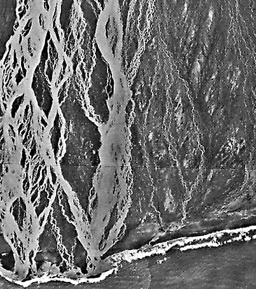
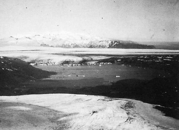
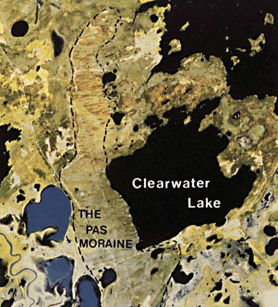
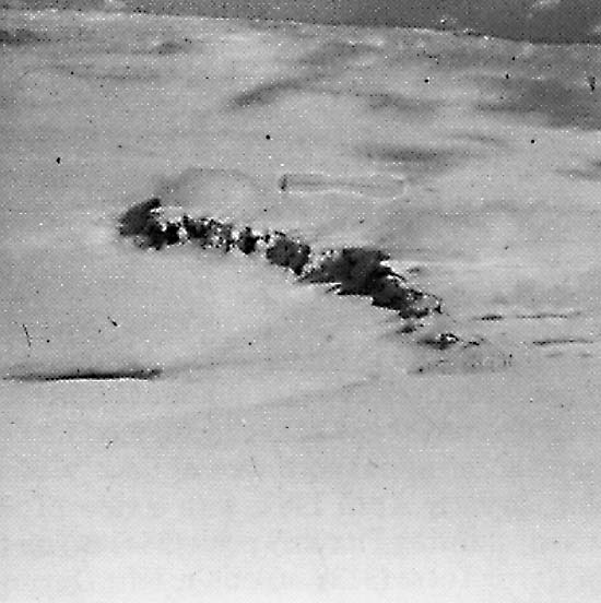
This Plate is a two-scene Landsat-3 RBV image mosaic of the 50-km wide Skeidarársandur, the largest of the four sandar (Márdalssandur, Medallandsandur, Brunasandur, and Skeidarársandur) between Myrdalsjökull and Öraefajökull (Preusser, 1976). Enormous quantities of sediment-laden (silt, sand, and gravel) meltwater streams traverse these sandar from the margins of the outlet glaciers to the coast, especially during the late spring and summer months (A). The sediment-charged streams create an intricate pattern of anastomosing streams (A) (Figure G-22.1) before debauching into the sea. Figure 22-1 is a pair of vertical aerial photographs (photomosaic) of part of the southeastern part of the Skeidarársandur showing the anastomosing stream pattern characteristic of such glacial outwash plains and the ephemeral delta forming at the coast. At various points along the coast (B) sediment-laden glacial streams breach the barrier beach and discolor the ocean water with glacial rock flour (Figure G-22.1). A glacial delta may even build out into the sea in some places (C). On the eastern side of Skeidarársandur, meltwater is derived from the terminus of Skeidarárjökull and from the numerous outlet glaciers such as Skaftafellsjökull and Svínafellsjökull, which originate from the Öraefajökull ice cap (Plate G-16) and descend through valleys to the Skeidarársandur outwash plain. Figure G-22.2 is a photograph looking east-northeast across glacial streams (Skeidará) on the upper part of Skeidarársandur toward the terminus of the Svínafellsjökull outlet glacier (see also Figure G-6.1). On the western side of Skeidarársandur, meltwater streams originate from the terminus of Skeidarárjökull and from Sídujökull. Proglacial lakes (D) can be seen in front of Skeidarárjökull. The ice-dammed lake Graenalón is visible at (E) (see Plate G-23). Glacial outwash plains along a coast usually have a very gentle slope from the terminus of the glacier down-valley or across a coastal plain to the sea, although the upper part can be relatively steep where the outwash material is much coarser. The upper part of Skeidarársandur, 25 km from the coast, lies close to the 100-m elevation contour, giving an average gradient of 4 m per kilometer.
| Fig G-22.3 |
|---|
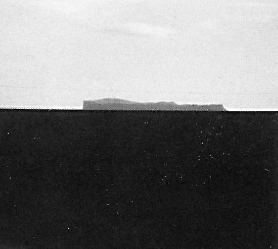 |
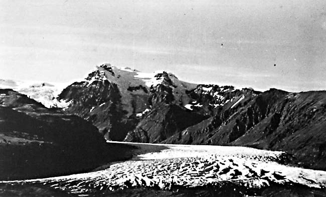
Figure G-22.3 is a view looking across Myrdalssandur toward Hjörleifshöfdi, a Pleistocene palagonite mountain that lies about 5 km to the south-southeast. Hjörleifshöfdi was probably at the coast at the time of the settlement of Iceland (ca. 874 A.D.), but is completely surrounded by glacial outwash deposits (dark-toned basaltic sediments) and now lies 3 km from the coast (Preusser, 1976). Note the extreme flatness of the topography in this part of the outwash plain, approximately 15 km south of the terminus of the Hofdabrekkajökull outlet glacier from Myrdalsjökull. Small drumlins have been mapped in the outwash plain north of Myrdalsjökull but are too small to be resolved on the Landsat-3 RBV image. Both Skeidarársandur and Myrdalssandur have been subjected to repeated periods of catastrophic floods resulting from jökulhlaups. Icelandic jökulhlaups can originate from the failure of ice-dammed lakes (Thorarinsson, 1940) or from subglacial volcanic and/or geothermal activity (Björnsson, 1975, 1976). Maximum discharges across Skeidarársandur are now usually in the range of 1 x 10⁴ m3/s from jökulhlaups originating in the Grímsvötn caldera (Figure 9-14) and estimated to be 2 to 3 x 10⁵ m3/s across Myrdalssandur from those originating in the subglacial Katla volcano within Myrdalsjökull (Thorarinsson, 1957). Jökulhlaups affecting Skeidarársandur have also originated from Öraefajökull (Thorarinsson, 1956b) and from Graenalón (Plate G-23). In the image, it is possible to see two lakes west of Skaftárjökull and Sídujökull, Langisjór and Thórisvatn, which have quite different spectral (gray tone) characteristics. Because Langisjór is no longer receiving sediment-laden glacial meltwaters from the western edge of Vatnajökull, its waters are clear. Thórisvatn, also a ground-water lake, was also completely clear until large engineering projects associated with the development of hydroelectric power plants on the Tungnaá river diverted the course of the glacial Kaldakvísl river into the northern "outlet" of Thórisvatn to create a storage reservoir. Sediment in suspension (glacial rock flour) has now altered the natural condition of Thórisvatn. Landsat 30517-11572 C and D, August 9, 1978.
Continue to Plate G-23| Chapter 9 Table of Contents.| Return to Home Page| Complete Table of Contents|