 |
 |
|---|---|
| Plate G-25 | Map |
|
|
|---|---|
| Plate G-25 | Map |
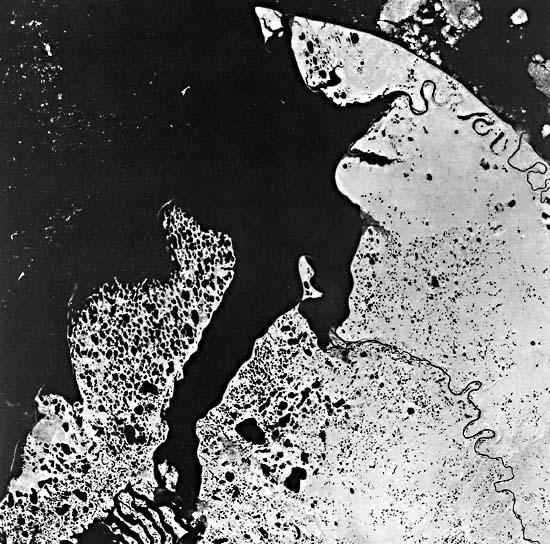
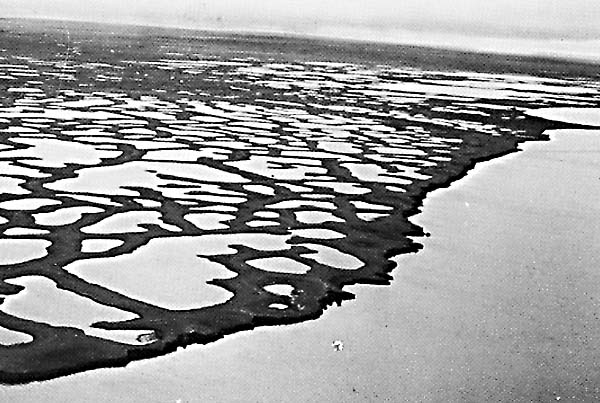
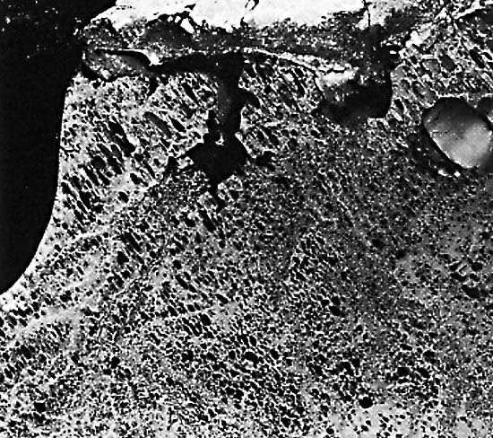
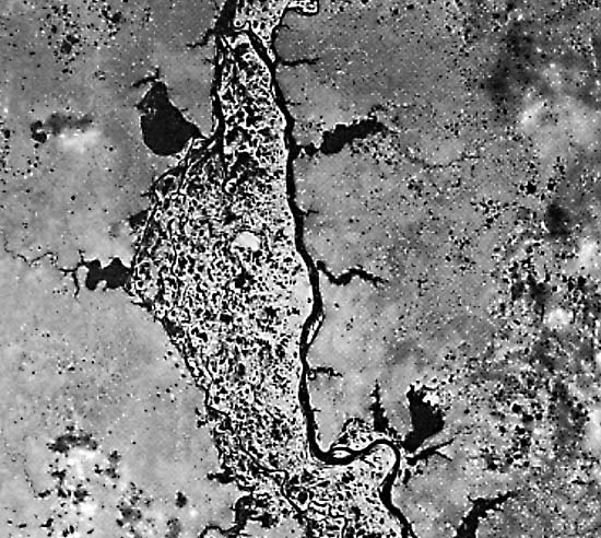
Thermokarst is defined as "karstlike topographic features produced in a permafrost region by the local melting of ground ice and the subsequent settling of the ground. cf: glaciokarst" (Bates and Jackson, 1980). The area encompassed by the Plate image is situated northeast of the present mouth of the Mackenzie River in the northwestern part of the Northwest Territories. It shows well-developed thermokarst topography dominated by numerous thaw lakes. Thermokarst lakes and related features are particularly prominent features on the low-relief coastal plains (Figure G-25.1), peninsulas, and islands which border the Arctic Ocean (Figure G-25.2) and outside the floodplains of north-flowing rivers in northern Russia, such as along the Ob River (Figure G-25.3).
Figure G-25.1 is an oblique aerial photograph of thaw lakes on Bathurst Island, Northwest Territories, Canada, looking southwest across Polar Bear Pass. Figure G-25.2 is a Landsat MSS image of thaw lakes formed in ice-rich permafrost on the coastal plain south of Point Barrow, northern Alaska. Figure G-25.3 is a Landsat MSS image of thaw lakes in discontinuous permafrost beyond the floodplain of the Ob River, northern U.S.S.R. (see Plate KL-8).
| Fig G-25.1 | Figure G-25.2 |
|---|---|
 |
 |
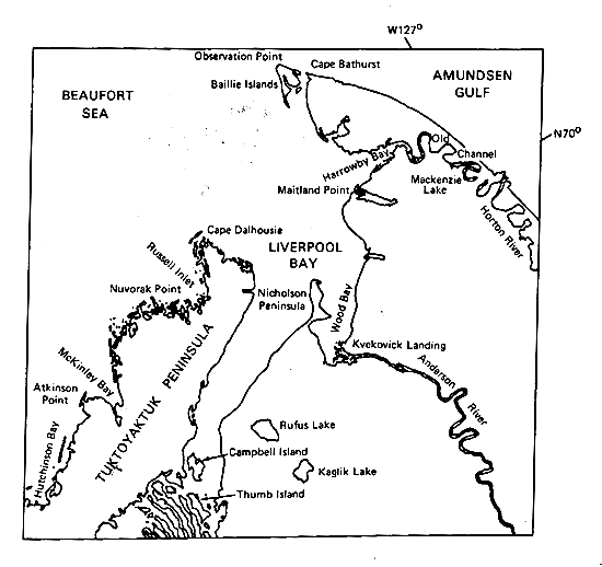
The Tuktoyaktuk Peninsula and the islands and linear landforms situated southwest of the peninsula are composed of Quaternary sediments; the remainder of the area is underlain by rocks of Cretaceous age (Fremlin, 1974). The area encompassed by the image, including the offshore submarine platform, was completely covered by glacial ice at the time of maximum extent of glaciation during the Pleistocene (Prest, 1983). In the Late Wisconsinan (the interval of the last ice sheet), however, the northern limit of the Laurentide Ice Sheet is considered to have extended along the southern edge of the Tuktoyaktuk Peninsula (Prest et al., 1967). Both the Tuktoyaktuk Peninsula and the northern and western part of the peninsula east of Liverpool Bay are composed of Wisconsinan outwash deposits. Ground moraine lies on the southwestern part of the Tuktoyaktuk Peninsula west of Campbell Island and the region from Nicholson Peninsula extending southwest through Rufus and Kaglik Lakes. Morainal ridges are visible southwest of Campbell and Thumb Islands. The remainder of the area south of Wood Bay is also mostly covered with ground moraine.
Tuktoyaktuk Peninsula contains numerous lakes formed through melting of the uppermost part of the underlying permafrost layer. Rampton and Bouchard (1975) noted that: "Permafrost-related processes, such as solifluction and soil creep, ice-wedge formation, frost shattering of boulders, pingo formation and the heaving of areas formerly covered by water bodies, have a major effect upon the landscape." This part of Canada lies within the zone of continuous permafrost, which has been measured at more than 92 m in thickness about 200 km to the southwest (beyond the area of the image) at Inuvik (Brown, 1967), and 366 m thick in a well drilled on Richards Island, about 150 km to the west-southwest (Rampton and Bouchard, 1975). The peninsula is slowly being destroyed by the encroachment of the Beaufort Sea, which is progressively melting the upper part of the subaerial permafrost. Between McKinley Bay, Cape Dalhousie, and the easternmost part of the Tuktoyaktuk Peninsula, the coastline has a decidedly ragged appearance caused by the incorporation of older lake shorelines into the advancing new shoreline. "Coastal retreat is occurring as headland erosion and landward movement of spits and bars, which lie offshore or between headlands, occurs" (Rampton and Bouchard, 1975). In their geologic studies of the northwest coast of the Tuktoyaktuk Peninsula (about 70 km southwest of the western margin of the image), Rampton and Bouchard used sequential aerial photographs to measure the rate of coastal retreat. They found the average annual rate of retreat quite variable during the past 3 to 4 decades, ranging between 3.8 and 7.6 m per year. During one coastal storm in September 1970, a coastal bluff retreated 13.7 m in 1 day. Rapidly changing spits are also characteristic of the coast.
| Fig G-25.3 |
|---|
 |
Submarine permafrost is present in the submerged coastal shelf; farther offshore, numerous submarine pingos have been mapped (Fremlin, 1974). Pingos also abound on the Tuktoyaktuk Peninsula and a belt extending west-southwest from Wood Bay (Brown, 1967). Although these and other periglacial landforms exist in the area, they cannot be resolved on Landsat MSS images.
Several other noteworthy geomorphic features that appear on the Landsat image should be noted. Large ice floes can be seen along the coast southeast of Cape Bathurst; smaller ice floes are present in the northwestern part of the image area in the Beaufort Sea. Several barrier beaches have formed on the northwest coast of the Tuktoyaktuk Peninsula, between Hutchinson Bay and Atkinson Point, at Atkinson Point, along the eastern shore of McKinley Bay, and at Cape Dalhousie. Spits have also formed at the tip of the Nicholson Peninsula on the southern part of Baillie Islands and at Cape Bathurst. Meanders are well developed on the lower reaches of the Anderson and Horton Rivers. The lowermost section of the Horton River represents an unusual geomorphic phenomenon. The advancing shoreline has "captured" the Horton River by intersecting one of the meander loops. The new mouth of the Horton River empties into the southwestern part of the Amundsen Gulf, where an arcuate delta has formed because of the limited wave energy. Landsat 1005-20021-7, July 28, 1972.
Continue to Plate G-26| Chapter 9 Table of Contents.| Return to Home Page| Complete Table of Contents|