 |
 |
|---|---|
| Plate G-26 | Map |
|
|
|---|---|
| Plate G-26 | Map |
South-central Asia contains mountain chains and basins whose average elevations lie higher than anywhere else in the world. This region is also one of the most tectonically active on Earth, with persistent rising of the crust to new heights. Temperatures at these higher altitudes are consistently low over most of this area expanse. Yet, examination of Landsat and Large Format Camera images from selected localities throughout the region (e.g., Plates T-48, T-49, T-50, and E-27) reveal that extensive ice sheets are absent, and furthermore, some of the signs of major glaciation of the rugged terrain are either lacking or have been modified. This sparsity requires an explanation.
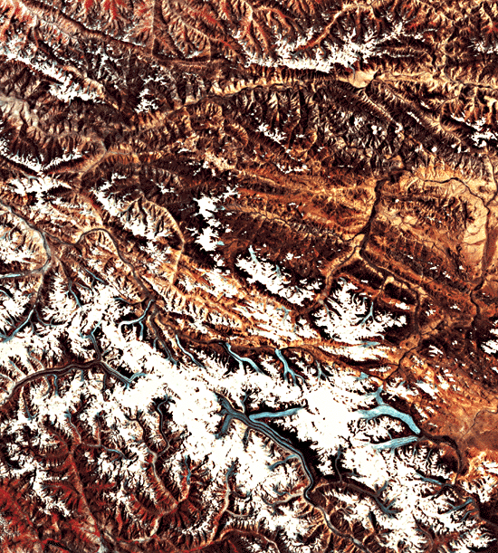
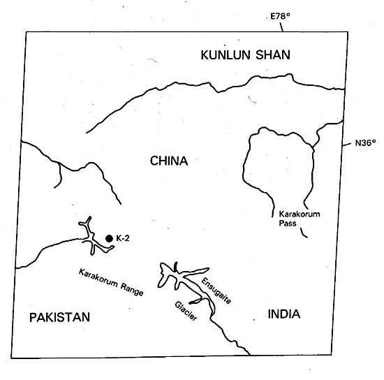
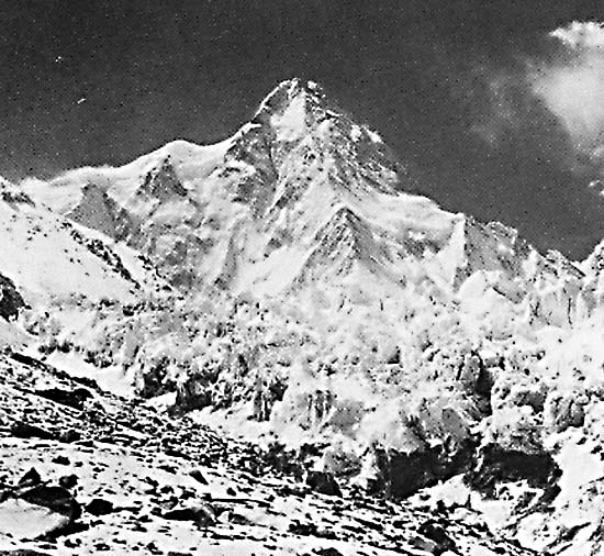
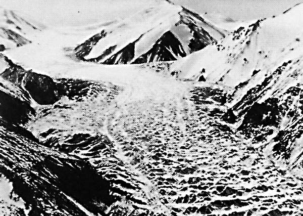
Perhaps the best example of the nature and extent of glaciation in this part of the world appears in this Plate. The scene lies in the Karakorum Shan, where Pakistan, India, and westernmost China, southwest of the Taklimakan, come together. Included in the scene is the famed K-2 (or its Chinese name, Quogir Feng; 8611 m), second highest peak on the continents (Figure G-26.1) and reputedly more difficult to climb than Mt. Everest (Qomolangma Feng). Emanating from it and the nearby mountain ridges are a series of valley glaciers that include Ensugaite (Yinsukati), at 42 km the longest in China. In some instances, lower segments of the valleys hosting these glaciers appear in the image to have well-developed U-profiles, but at lower elevations there and in the mountains to the north, the valleys and particularly their tributaries seem to have narrow floodplains and sloping walls more akin to a V-shape. In areas not now being actively glaciated, older arêtes are indicated by knife-edge ridges, but cirques are not conspicuous in this image at Landsat resolution, although ground photographs indicate their presence. In the Nyainqentanglha Shan region some 1500 km to the east, modern glaciers also exist, as seen in the Landsat image shown in Figure G-26.2, but again, wide U-shaped valleys are uncommon relative to the more typical V-profiles cut into high mountains whose relief can exceed 4000 m. To the north in the Qilian Shan, active glaciers such as Laohugou (Figure G-26.3) descend through the steep-walled valleys widened by earlier glaciation.
| Fig G-26.1 | Figure G-26.2 |
|---|---|
 |
 |
Glaciation in West China has been described by Shi Yafeng and colleagues (1985, unpublished review/personal communication) and by Chi and Ren (1980). Glaciers persist today in the same mountain regions (Shans) but are notably diminished in area. The total area now occupied by glaciers in 56 000 km2, with the largest individual fields being the Himalaya Shan (11 005 km2), Kunlun Shan (9973 km2), Tian Shan (9196 km2), Nyainqentanglha Shan (7536 km2), and Karakorum Shan (4650 km2). Chinese glaciologists recognize two major types of glaciers: (1) continental, which develop in regions in which precipitation ranges from 300 to 1000 mm per annum, the snowline is usually higher, and the mean air temperatures at the height of the snowline range between -6° and -15°C; (2) maritime, which represents regions in which weather conditions are strongly influenced by monsoonal precipitation ranging between 1000 and 2500 mm per annum and mean air temperatures at snowline stay at -2° to -4°C. (The second type is exemplified by glaciers in the Nyainqentanglha and Hengduan Shans.)
Shi and his colleagues at the Institute for Glaciology and Cryopedology in Lanzhou tie the glacial history of West China to a combination of climatic changes and increasing elevations in the Himalaya and other ranges in its trend, the Tibetan (Qinghai-Xizang) Plateau, and the fringing ranges to the north. From Early through Middle Pleistocene, two glaciations were driven by cold but humid climates as the region underwent continuing uplift. (Higher elevations may have been 2000 m lower than present.) Glaciation then was considerably more widespread than now, but no large continuous ice caps were formed. Valley glaciers, some with maximum lengths up to 100 to 200 km, did join in trellis-like networks. By the start of the Late Pleistocene, the climate had shifted to cold and dry as elevations generally rose. Two more glaciations have been recorded during this interval. Neoglaciation began in the Holocene, as permafrost conditions took over much of the entire region.
| Fig G-26.3 |
|---|
 |
The relatively small number of glaciers surviving now in the "roof of the world" is explained by the general diminution of moisture available to provide snow from which to form ice by cold infiltration and congelation. The relief profiles characteristic of most of the higher mountains probably reflect the dominance of downcutting by streams and valley wall widening (decreasing slope angles) brought about by the high energetic of stream erosion that has modified older Pleistocene glacial topography. (GCW: N. M. Short) Landsat 30135-04492, July 18, 1978.
Continue to Chapter 9 References| Chapter 9 Table of Contents.| Return to Home Page| Complete Table of Contents|