 |
 |
|---|---|
| Plate G-7 | Map |
|
|
|---|---|
| Plate G-7 | Map |
A piedmont glacier can be defined as "the lobe-shaped, expanded, terminal part of a valley glacier [see Plate G-9] spread out over broad lowlands at the base of mountains" (Armstrong et al., 1973). Piedmont glaciers are also associated with outlet glaciers and are common in glacierized mountainous areas fringed by a coastal plain or by a region of low relief. In Plate G-8, several valley glaciers on Bylot Island have an expanded, fan-shaped terminus typical of piedmont glaciers. In this Plate and Plate G-22, Skeidarárjökull, one of the many outlet glaciers from Vatnajökull, has the characteristic lobate form of piedmont glaciers at its terminus.
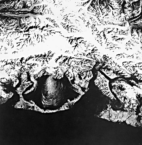
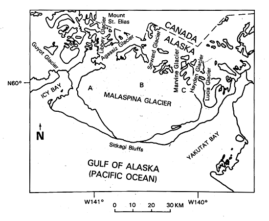
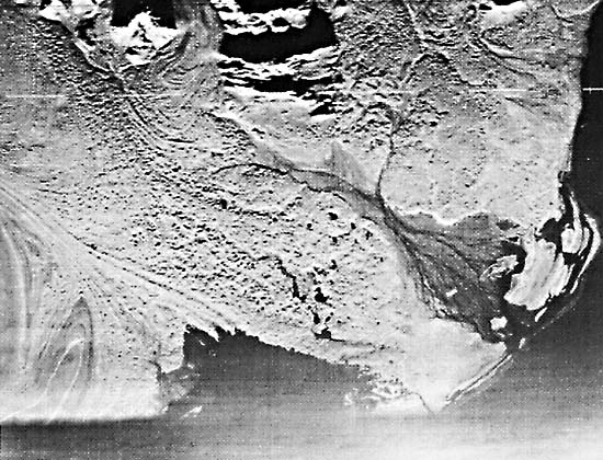
The classic type locality of the piedmont glacier, however, is the Malaspina Glacier in southeastern Alaska (Sharp, 1958b). Plate G-7 is a Landsat MSS image of the Malaspina Glacier. The Malaspina Glacier is an extremely complex glacier, deriving its ice from multiple highland sources, although its main source is the Seward Glacier, as seen in the index map of the area (from Sharp, 1958b). The Malaspina Glacier nearly reaches sea level at Sitkagi Bluffs on the Gulf of Alaska.
As Field (1975, p. 233) pointed out, "The Seward/Malaspina complex is a huge body of ice consisting of an extensive névé or icefield, the "upper" Seward Glacier, and a much narrower "lower" outlet glacier through which ice drains to the enormous piedmont of the Malaspina Glacier."Field (1975, p. 235) provides an additional description of the Malaspina Glacier: "The lobate piedmont fronts the coast from the bend of Yakutat Bay to Icy Bay, about 65 km., and from the coast northward to the mountain front its width is about 45 km.; its area is [about] 2195 km2. Surface altitudes range from about 25 m. at the outer margin to about 600 m. at the lower end of the Seward Glacier, its main tributary. Other tributaries of considerable size, east to west, are: Hayden and Marvine Glaciers, east of the Seward Glacier, and Agassiz and Libbey Glaciers to the west."
| Figure G-7.1 | FigG-7.2 |
|---|---|
 |
 |
"Seismic exploration shows that the glacier is 610 m thick and its basin extends as much as 300 m below sea level; the evidence indicates that the basin probably originated by central glacial erosion and peripheral deposition (Allen and Smith, 1953)."
Only satellite images can provide a complete overview of the Malaspina Glacier because of its large area. Sharp (1958a), for example, had to compile a mosaic of about 100 vertical aerial photographs in his study of the contorted moraines. In this Plate, the three distinctly different parts of the Malaspina Glacier can be clearly delineated (see index map): (A) the western lobe, whose primary source is the Agassiz Glacier, 5 km wide where it exits its valley; (B) the central lobe, whose source is the Seward Glacier, only 4 km wide where it leaves its valley; and (C) the smaller eastern lobe, whose source is the Hayden and Marvine Glaciers (index map).
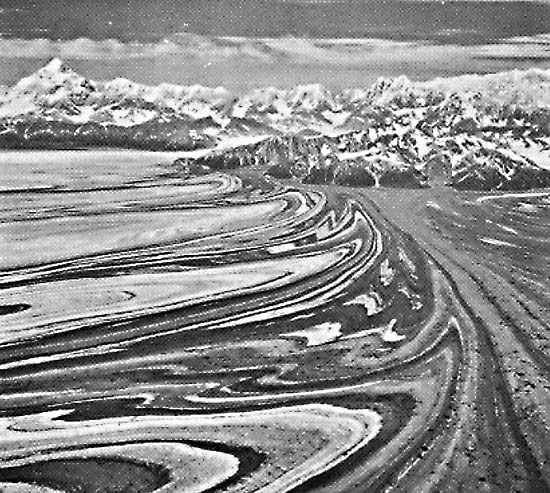
The flow of such a huge volume of glacier ice through narrow valleys before fanning out on the coastal plain causes erratic variations in the velocity of glacier flow, manifested so clearly by the contorted moraines characteristic of the central lobe of the Malaspina Glacier (Figure G-7.1, an oblique aerial photograph of the eastern part of the Malaspina Glacier taken on August 15, 1969). Contorted moraines on a glacier are an indication of surge behavior. Field (1975, p. 236) notes that, "Post (1969) classified [a] tributary of the Agassiz, the entire Seward Glacier, the Hayden and Marvine Glaciers, and the eastern two-thirds of the Malaspina as surging glaciers." The contorted moraines of the eastern edge of the central lobe and the medial moraines along the boundary with the smaller eastern lobe are clearly shown. Mount St. Elias (5492 m) can be seen in the left background, just beyond where the Seward Glacier, the primary source of the Malaspina Glacier, exits from its valley.
| Figure G-7.3 |
|---|
 |
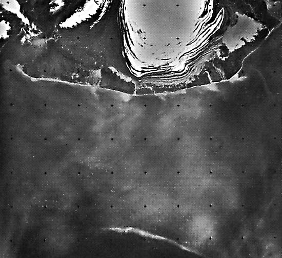
The contorted moraines on the eastern side of the central lobe of the Malaspina Glacier have been investigated by Washburn (1935) and Sharp (1958a). They are especially well depicted on Landsat-3 RBV images such as the one obtained on June 11, 1981 (Figure G-7.2), showing the terminus of the Malaspina Glacier and the large contorted moraines that are characteristic of the central lobe. Contorted moraines are also visible on the western lobe. Note also the numerous proglacial lakes along the contact with debris-covered ice and the extensive "pitted" morainic debris in the interlobate area between the western and central lobes. Hall and Ormsby (1983) experimented with combining August 3, 1978, Seasat synthetic aperture radar (SAR) images (scene 05520276) with an August 24, 1979, Landsat image (21675-19482) of the Malaspina Glacier. They found that glacier flow patterns were best shown on the Landsat image, but that the SAR image showed many interlobate features because of radar´s greater sensitivity to surface roughness (e.g., heavily crevassed areas), and the low reflectivity of the debris-covered surface made analysis of the Landsat image difficult. The same conclusion that Hall and Ormsby (1983) made with regard to the Seasat SAR image can also be reached by analyzing a side-looking airborne radar (SLAR or SLR) image (X-band) of the upper part of the Malaspina Glacier (Figure G-7.3). Landsat 2956-19292-7, September 3, 1977.
Continue to Plate G-8| Chapter 9 Table of Contents.| Return to Home Page| Complete Table of Contents|