 |
 |
|---|---|
| Plate G-8 | Map |
|
|
|---|---|
| Plate G-8 | Map |
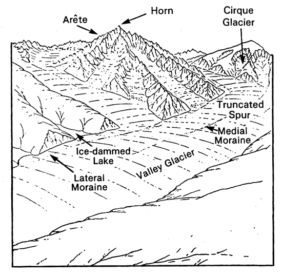
A cirque glacier is defined as "a glacier which occupies a separate rounded recess which it has formed (or modified from a small gully) on a mountain side" (Armstrong et al., 1973). Cirque glaciers are the most common type of glacier found in glacierized mountain regions in temperate latitudes (see Figure G-8.1, from northern Iceland). The cirque erosional landform (see Plate G-12 and Figure 9-20) is also common in such regions and signifies the presence of a glacier at some time in the past. A cirque glacier that expands beyond its basin is in a transition to a valley glacier (Figure G-8.2). Once the cirque glacier expands down-valley, it has evolved into a true valley glacier (see Plate G-9 and Figure 9-20). Several cirque glaciers in the upper reaches of a valley may combine to produce a large composite valley glacier. The erosive power of the main valley glacier greatly exceeds that of the cirque glacier. After the glaciers disappear, the cirque and its downslope extension is left as a "hanging valley" (Figure 9-20) above the main valley.
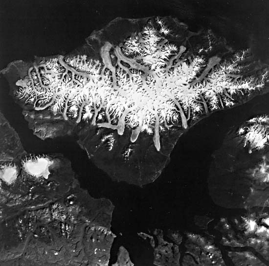
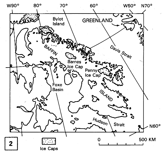
This Plate is a Landsat MSS false-color composite image of Bylot Island and vicinity, Northwest Territories, Canada, showing cirque glaciers and valley glaciers. Bylot Island is centered at about 73°15´N latitude and 78°30´W longitude and is located to the east of the Borden Peninsula off the northeast part of Baffin Island (see Figure G-5.2). It is roughly diamond- shaped, about 180 km long and 110 km at its widest point. The maritime climate ensures an ample supply of snowfall to support the numerous glaciers that dominate the higher elevations of the island (American Geographical Society Glacier Studies, 1975a; Mercer, 1975a). There, the total area of glacial ice is about 4895 km2 according to Bird (1967). Glaciers reach the sea on the northern coast at Maud Bight (A) and west of Cape Hay (B) and on the southern coast at the terminus of Sermilik Glacier (C); piedmont glaciers have also formed in several lowland areas, such as at (D). Not much information is known about fluctuations of the glaciers; however, Mercer (1975a), based on work by Falconer (1962), noted that glacier termini generally appear to be stationary or receding, except that the glacier (E) that occupies the valley inland from Bathurst Bay apparently advanced between 1948 and 1958.
| Figure G-8.1 | FigG-8.2 |
|---|---|
 |
 |
The rugged Byam Martin Mountains, with their resistant core of gneisses (Jackson, 1981), have been extensively modified by glacial erosion, The Landsat MSS image (Plate G-8) shows numerous glacier-filled cirques formed at the heads of valleys (F) and along the valley sides (G). In most cases, the cirque glacier has extended well beyond the cirque to become a true valley glacier (H). Cirques along valley sides are occupied by cirque glaciers that merge with the main valley glacier (I). If Bylot Island were suddenly to be deglaciated, these valley-side glaciers would become hanging valleys.
Other features associated with glaciers and glacier erosion and deposition can be described from Plate G-8. The knife-edged ridge separating two cirques is called an arête (see also Plate G-12 and Figure 9-20), and numerous arêtes can be seen on the image, such as at (J). When valley glaciers reach lowlands and are no longer constrained by valley walls, their terminal part may spread out in a fan-shaped lobe called a piedmont glacier (D). Therefore, a cirque glacier may extend down-valley as a valley glacier (K) and then spread out over the lowlands as a piedmont glacier. Glacial outwash plains (sandar) (L) are well developed at Bathurst Bay and north of Cape Burney. A medial moraine is prominent on the terminal part of the glacier north of Cape Burney (M). A proglacial lake (N) associated with the small piedmont glacier south of Cape Liverpool has the distinctive robin´s egg blue color of glacial rock flour in suspension. All around the coast of Bylot Island, this distinctive blue signature of sediment-laden glacial meltwater can be seen (0). On the west coast of Bylot Island, two prominent glacial deltas are extending new land into Navy Board Inlet from sediment-laden glacial meltwater emanating from two major glacier systems in each valley (P). Across Navy Board Inlet, on the Borden Peninsula, two small unnamed ice caps and associated outlet glaciers are visible (Q).
| Figure G-8.3 |
|---|
 |
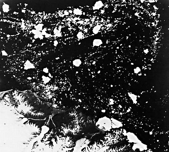
Because of the narrow width and relatively low elevation of terminal and lateral moraines, such moraines can generally be only inferred on the Landsat MSS image. Figure G-8.1 is a Landsat-3 RBV of the northeast part of Bylot Island. Although the near threefold increase in spatial resolution make some glacial landforms and glaciological phenomena easier to discern, it does not markedly improve the capability of mapping moraines on Landsat images.
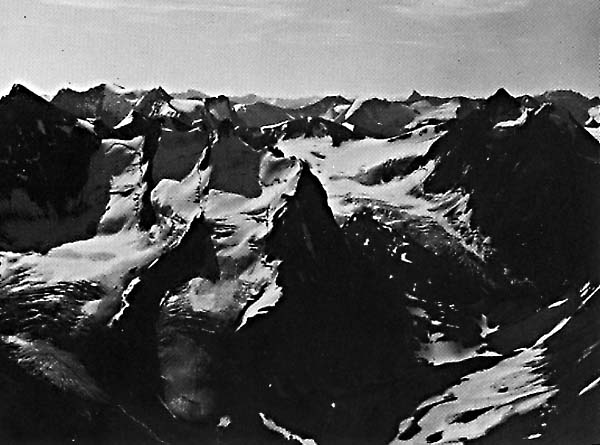
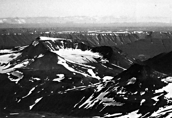
Figure G-8.2 is an oblique aerial photograph of three prominent cirque glaciers, with prominent bergschrunds (headwall crevasses) in the Muskwa Range of the Canadian Rockies, British Columbia, Canada, arêtes separating the cirques, and pyramidal peaks called horns. Note that most of the arêtes are at a fairly uniform level or Gipfelflur (summit plain). Icefalls are characterized by the zone of transverse crevasses where the glaciers exit their respective cirques. Figure G-8.3 is an oblique aerial photograph (August 15, 1981) of a small remnant of a cirque glacier on the northwestern side of Kerling. The cirque has been eroded in Tertiary flood basalts on the southeastern part of the Tröllaskagi peninsula of northern Iceland. The view is looking southeast toward the table mountain, Herdubreid (Figure 9-17) in the distant background. Landsat 20204-16513, August 14,1975.
Continue to Plate G-9| Chapter 9 Table of Contents.| Return to Home Page| Complete Table of Contents|