

Even as typesetting for this book neared completion, a dramatic event took place that promises to open up a new vista for the practice of geomorphological observations from space. On the night of February 21, 1986, in French Guiana along the Atlantic coast, a French Ariane rocket successfully launched a new Earth-observing satellite known as SPOT (Systčme Probatoire pour l´Observation de la Terre). This system is especially suited to the study of terrestrial landforms in the synoptic mode, already demonstrated as scientifically valuable from similar NASA missions, but with the added advantage of providing oblique and stereographic images of the Earth´s surface. Developed by the Centre National d´Etudes Spatiales (CNES), France, in cooperation with Belgium and Sweden, SPOT will provide a variety of image and computer-compatible tape products to a worldwide community of users through two primary outlets-SPOT IMAGE of France (Toulouse) and SPOT Image Corporation (Reston, Virginia, U.S.A.)-as well as numerous SPOT distributors located in many countries of the world.
The SPOT satellite operates in a sun-synchronous, near-polar orbit at a nominal altitude of 832 km. Its repeat cycle over the same track is 26 days (yielding 369 tracks per orbital cycle). The next track immediately to the west of a given track is overflown 5 days after the adjacent eastern one. Local solar time in the descending node at the equator is 10:30 a.m.
| Figure EP.1. A false-color composite of a 60-km wide scene of part of the Atlas Mountains of North Africa (see Plate T-30) produced by CNES-IGN from the three-band (multispectral mode) HRV sensor (20-m resolution) on the SPOT satellite. This was the first color version released by SPOT Image, Inc. after launch: the color balance has since been modified for this product, but the original version is reproduced here for esthetic reasons (acquired February 23, 1986). | 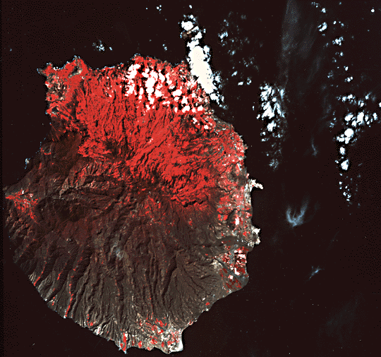 |
|---|
The payload is a pair of identical sensors known as "high-resolution visible" (HRV) instruments. Each HRV covers a ground swath width of 60 km; operating side by side, the HRVs achieve an effective ground swath of 117 km (slight sidelap). The basic instrument consists of the technologically advanced "push-broom" scanner that comprises a linear array of 6000 charge-coupled device (CCD) detectors. All detectors (each representing a pixel in the resulting image) are activated simultaneously by incoming radiation; a mechanically oscillating mirror is not needed because the charge on each device is "read" electronically in sequence. An image is produced from the signals received from the CCD linear array as it moves forward in orbit to produce a succession of lines.
The HRV can function simultaneously in two modes: the panchromatic mode comprises a single band in the 0.51-to 0.73-µm range of the visible spectrum; the multispectral mode consists of three bands in the intervals 0.50 to 0.59,0.61 to 0.68, and 0.79 to 0.89 µm (just within the near infrared). Separation of incoming radiation into these spectral bands is accomplished by a beam-splitter assembly at the focal plane. Effective resolution at nadir is 20 m for the multispectral mode and 10 m for the panchromatic mode. The three-band mode permits registration of each band through color filters to generate a false-color composite.
| Figure EP.2. Another SPOT false-color composite image showing the entire Gran Canaria, an island volcano in the Canary Islands several hundred kilometers west of the Moroccan coast off North Africa. Scene dimensions are approximately 50 by 50 km (acquired February 24, 1986). | 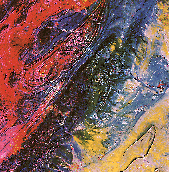 |
|---|
An innovation on SPOT not found on the Landsats is a movable mirror that allows off-nadir viewing across track (normal to the orbital path) over an angular range of ± 27°. Movement is in incremental steps so that intermediate angles can be set. This pointable mirror capability increases the options for viewing areas within a 950-km wide corridor at greater frequencies than those allowed by the 26-day revisit cycle. Depending on latitude, an area can be imaged at least twice during a week (seven times per cycle at the equator; more often at higher latitudes). SPOT offers the first opportunity for global off-nadir imagery using a digital sensor. Judging from experience with hand-held photographs taken by astronauts, oblique images of Earth from space present yet another invaluable perspective for describing and interpreting landforms by their topographic signatures. This off-nadir function of the HRV also permits stereo imagery to be acquired. The same area is viewed at different angles from different orbits so that the two images constitute a stereo pair. Of course, this side-looking stereo will not match the registration and photogrammetric calibration obtainable from nadir-looking systems (e. g., the Large Format Camera). Likewise, cloud cover will frequently compromise the stereo expression of the scene, but the large number of passes over an area during the lifetime of the satellite ensure a high likelihood of obtaining stereo pairs with minimum cloud cover and at similar seasonal times. Eventually, stereo coverage of nearly all of the Earth´s land surface is now a realistic possibility before the end of this century.
| Figure EP.3. A subscene (covering approximately 13 km on a side) of Nice, France, and environs, imaged on February 23, 1986, by the HRV panchromatic mode (10-m resolution) scanner on the SPOT satellite. Note details in the urban sections of the image. | 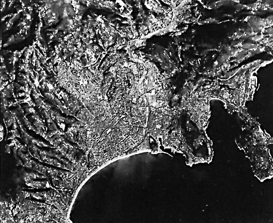 |
|---|
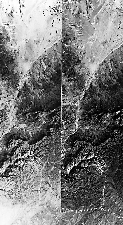
SPOT has already obtained a large number of scenes of much of the world. (Data are telemetered (downlinked) in real time to some receiving stations already on line; tape recorders permit data acquired outside the station range to be sent back later.) Those shown on the next two pages are indicative of the products offered by SPOT. Of special interest to all geomorphologists are the stereo images of an African site. Compare this set to the computer-generated stereo image from Landsat shown in Figure 12-9a.
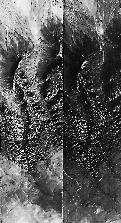
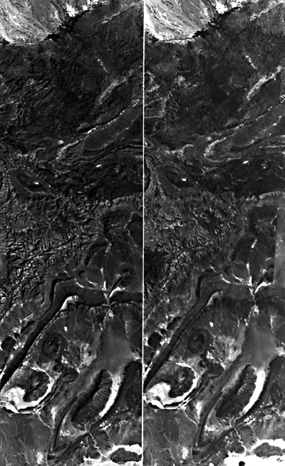
| Figure EP.4. Two stereo pairs selected from parts of two adjacent scenes of a plateau-escarpment-plains near the Libyan/Tunisian border (N32 00; E 11 10) by the SPOT HRV panchromatic scanner on February 24 and 25, 1986. The strips are mounted with spacings that favor use of a pocket steroscope or the unaided eye. For the left image, the HRV was pointed east at an incidence angle of 24° (off nadir); for the right image, that angle was 10° off nadir ("looking" to the west). The faint vertical lines are artifacts of initial processing. | |
|---|---|
 |  |
The emergence of SPOT on the international scene represents still another important step forward in the analysis of the Earth´s land surfaces and exploration for its resources. It is hoped that the study of the Earth from space will become as commonplace tomorrow as photogrammetry and ground-truthing are today.