
The Applied Information Sciences Branch (Code 935) at NASA Goddard Space Flight Center has developed a program called Photo Interpretation Toolkit (PIT) which performs classification operations similar to those we've introduced from IDRISI. The chief difference is in the mode of selecting training sites. Instead of circumscribing these sites with polygons, as in IDRISI, the PIT allows the user to block out continuous clusters of individually-sized sample squares. The user can display the clusters directly in the screen image at selected site positions. Users can also select one of several classifiers to match unknown pixels to those for classes with similar statistics, derived from the training-site blocks. We show an example next, that uses PIT's Probabilistic Neural Network classifier. (Note: the person doing this classification at Goddard was a programmer with limited experience in actually identifying classes.)
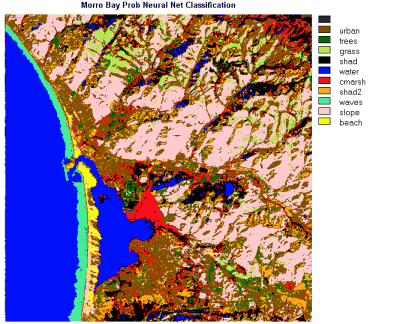
In this version, only 10 classes were established (the upper limit at the time). The resulting product shows similarities to the IDRISI Minimum Distance version (in which, there are 13 classes) but it is a simplification of the latter that fosters easier interpretation. However, several classes show notable misclassifications: areas of blue assigned to Water are found scattered inland (these are probably associated with shadows which have similar, low DN values); the reds related to Marsh (which should be confined to the river delta) also appear in widespread places, including the higher mountains; and the red-brown color given to Urban is in too many places that are certainly not urban. The orange, identified as Shad2, is definitely not shadows, but corresponds to areas in the scene that have bright tones in the color composite images. This was a bad choice of a class.
In Appendix B, PIT is now accessible to you for interactive use. Among the several data sets included is this Morro Bay subscene, of which you are now quite familiar. If you feel adventuresome after this exposure to image processing, you may want to try your hand at carrying out your own processing on Morro Bay, using the PIT processor, after teaching its procedures to yourself using the "cookbook" in Appendix 1.
Enough! If you have reached this point by working through this entire Section and reasoned along with us in examining and analyzing the various Morro Bay images, you have become well-schooled in the basics of image interpretation. You are ready, as curiosity prompts you, to call up the images in the next scene - a geological study of a prominent fold structure in Utah - and any of the images in other scenes that have been placed on line.
BUT, WAIT! If you were in a classroom instead of on the Net or working on a CD-ROM, you know the "curse" to expect after completing the first major block of information. An Exam!. We have devised a rather comprehensive set of questions based on image interpretations that we now invite (urge) you to undertake, in order to prove to yourself that you have evolved into a full-fledged expert in analyzing remote sensing data. We have reproduced a goodly number of scenes and computer maps that cover a single full Landsat MSS scene, with in south-central Pennsylvania centered on the state capital, Harrisburg. (These have been taken from the Landsat Tutorial Workbook.) All the relevant questions and illustrations have been put on the special add-on page, which you can reach by clicking here. These have their own answer sheet, accessed in the usual way. This will be the ultimate Q & A challenge we toss at you in this Tutorial. Rise to it. Press "here" - we dare you!!
_________________________________________________________________________
For further background, information, and reading underlying Principles of Computer Processing, with emphasis on Remote Sensing, consult:
Avery, T.E and G.L. Berlin, Fundamentals of Remote Sensing and Airphoto Interpretation, Ch. 15, Digital Image Processing, 1992, Macmillan Publ. Co.
Condit, C.D. and P.S. Chavez, Jr., Basic Concepts of Computerized Digital Image Processing for Geologists, 1979, U.S. Geol. Surv. Bull. 1462, Wash. D.C.
Jensen, J.R., Introductory Digital Image Processing, 2nd Ed., 1996, Prentice-Hall, Inc.
Lillesand, T.M. and R.W. Kiefer, Remote Sensing and Image Interpretation, Ch. 10, Digital Image Processing, 1987, J. Wiley and Sons, Inc.
Moik, J.G., Digital Processing of Remotely Sensed Images, 1980, NASA Special Paper 432, U.S. Govt. Printing Office.
Sabins, F.F., Remote Sensing: Principles and Interpretation, Ch. 7, Digital Image Processing, 1987, W.H. Freeman & Co.
Swain, P.H. and S.M. Davis, Remote Sensing - The Quantitative Approach, 1978. McGraw-Hill Book Co.

Collaborators: Code 935 NASA GSFC, GST, USAF Academy Webmaster: Bill Dickinson Jr.
Primary Author: Nicholas M. Short, Sr. email: nmshort@epix.net
Contributor Information
Last Updated: September '99
Site Curator: Nannette Fekete
Please direct any comments to rstweb@gst.com.